These images represent the old and new urban forms of the Middle East and North Africa. in what ways are the old cities preserved and modeled in the new ones?
These images represent the old and new urban forms of the Middle East and North Africa. in what ways are the old cities preserved and modeled in the new ones?

I attempted to write a response to this image before and realized that I do not actually know what a typical building should look like in the MENA region. What made me realize this was that I had a hard time discerning what was MENA in origin and what was not when examining the buildings of the old and new images together. The more that I look at the alleyway in the upper right though I can see that it is an area of this city that evolved out of need and resources and that sometime it appears that the need outstripped the available resources.
For example, the bridge that connects one side of the alley to the other has a sign on it that might actually be for a restaurant or some other business. This is quite unusual when examined from an American perspective because unless the owners were going for a back alley funk appeal, the restaurant would not usually be found in an alley. In comparison the building on the left which also has a bridge that crosses the road looks entirely modern and very western. Here the funk is added by creating an asymmetrical building. The difference though is that even with the uneven characteristics from side of the road to the other it still looks entirely planned. This is something that modern architects like to do, for example, The Dickson just off of campus. It is designed to look like it grew up over time but unfortunately it still contains the vision and style of one designer.
The next two images echo this same difference. The map on the lower right is a section of a city that again grew from need and ability but without a cohesive plan or design. This map would probably make an American city planner have nightmares. Where are the roads and parking lots? Where if you look at the mall or shopping center on the left it seems to have a more Arabian feel but in a campy Hollywood way and not one that is as organic as the alley or the city map. This market has a western order to it that does not seem to conform to the chaotic alley or city. There is a theme and I would not be surprised if the designer or team did not have some formal western training. The way it is decorated definitely looks Middle Eastern or North African but it is so continuous and unbroken that it had to be planned.
The final image has to stand on its own for a number of style reasons. The most striking part of this image is the Burj Al Arab which is possibly the most expensive hotel on the planet. The design which looks like a sailing ship also seems like part of a flower. It is beautiful but at the same time screams opulence. This is entirely out of character with the old alley and the modern buildings. The rest of the skyline looks like it could be in Dallas or any other large western metropolis. There is a very tall spire towards the center left that is striking but it does not really say MENA when you look at it.
Good discussion.
A central citadel, courtyard housing, tenuous ally-streets, and large indoor markets are key characteristics of typical Middle-Eastern urban form. The two images on the right work together to show the old urban form of the Middle East and North Africa. The top-right photograph showcases these components. Windows are kept above eye level and doors are off-set from one another in order to maintain a strict level of privacy. Additional space is obtained by building over the alley. The passageway is wide enough for two camels to pass and the archways are tall enough as to allow a camel and its rider to pass underneath. The urban condition shown in this picture is a result of the private areas of a house being pushed to the periphery in order to allow an open courtyard in the center.
The open-space-to-occupied-space relationship is showcased in the figure-ground map on the bottom right is indicative of courtyard housing show in the picture above. Large streets section off quadrants of the larger city. Each of these quarters has its own services, such as water provisions and mosque, and a madrasa. The thin passage-ways are seen in the image as the thin, white free space between buildings. The larger portions of open space are allocated to the interior areas of a house (making a courtyard house).
Additionally, in the space outside of the large streets in the bottom-right image, one can see the development of newer urban forms. These take on the characteristics of the previous environment but become larger in scale and sometimes more regularized in to noticeable blocks.
The change in scale from the old to new can also be seen in the picture on the upper-left. Here, the tenuous characteristic of courtyard houses is transformed in to a mid-rise apartment building. Open space has been pushed to the exterior of the building, rather than kept to the interior as was the case in the old urban form. However, it is interesting that the arched passageway remains despite its noticeable growth in scale. The old city is preserved in aesthetic ways, despite the dramatic change in scale, shape, arrangement.
The middle-left image shows a large in-door market which was a common trade spot in old Middle East and North African cities. Although modified with electricity and possibly larger open expanses, the idea of an enclosed indoor market space is preserved as a place to show, sell, and buy goods. Although an exterior image of this market isn’t shown, one can predict that the exterior walk-ways are similar to what is shown in the top-right image. The “street-scape” is able to be void of the marketplace commonly found on city streets in other parts of the world because of the indoor market.
The image to the lower-left shows a case in which old urban form has been disregarded in acceptance of modern steel-and-glass structures. This type of urban development is common in the gulf region of the Middle East where oil money has driven a swift rural-to-urban migration and massive urban development. In situations like the one shown, the relationship of open-to-occupied space, scale of structures, and arrangement of buildings has been completely changed.
Very nice, good observations.
The old cities in the Middle East and North Africa molded themselves across the hills. They contained a citadel, market, mosque, madrassa, and residential quarters. The markets were in the middle of cities and were basically massive indoor commerce centers where spices, glassware, clothes, and other things were sold. The old cities were fairly sophisticated. For example, Baghdad had a system of cisterns underneath the city. The residential areas were high density with streets just wide enough for two camels. There was lots of privacy. The dwellings contained a courtyard towards the center so that people could walk around freely without clothes on, but still feel like they were outside. The ground level was for females, and the upper level for males. There were usually only windows on the second floor, and if there were openings on the first floor, they were covered. Also, the doors were offset from the house across the street so that people couldn’t see into each other’s houses.
In the new city, the housing transitioned to French Mediterranean style, multi-story apartments, the streets were widened, and the city was partially modernized. The new city sprawled out around the existing city, which left the old city preserved inside. At this time, there was a mix of the old city and new in the urban form and architecture.
Even later on, organic sprawl east of the Gulf occurred, and massive urban development took place due to the discovery of oil. This created the modern city, which is seen in the bottom left image. The concept of a citadel and central market place in the old city can be seen in similar forms in the modern city’s downtown area. Trade was established in old port cities as a source of income, and the modern city’s income came mostly from oil. This version of Middle Eastern and North African cities are very rich, unlike the old cities.
All three populations/cities were created by organic urban sprawl, creating an oval shaped development pattern. There is evidence of the old city in the new city, and same for the new city in the modern city. Each addition was built around the existing city.
-Morganne Bryner
Good discussion.
The Middle East and North African region has been colonized by various groups over decades in succession. As a result, their urban forms are in many ways very similar, while their architecture can be very diverse and often a reflection of their colonization.
The image on the top left represents a new urban form. The arch which spans the causeway below, incorporates the Islamic past on a grand scale. The rest of the building however, speaks to modern modes and styles of construction. It is taller than what might be considered as a traditional building in this region, and its material quality and exterior finishes speak to a more European, if not contemporary aesthetic.
It also appears to be an object building, standing alone on some allotted space and not crowded by any other buildings and thereby goes against the grain of the typically densely populated make-up of many of these cities. It is either in a city that was not subject to rural to urban influx, or on the outskirts of a city that experienced that phenomenon.
The image on the left below it, appears to be one of a market – a concept that was very important in traditional older cities. Even though it appears to be plying modern goods and is housed indoor, it retains the essence of the souk or bazaar.
It appears to be housed in a building of sorts with a vaulted ceiling – a recurring architectural element of the Middle East and North Africa. The walls are finished in a saffron/turmeric color (no doubt inspired by the spices used in this area) with intricate tile elements that border the space and comprise the medallions on the ceiling – a testimony to the history of the place.
On the lower left, is the Burj al Arab, which preserves the old city in a very different way, as it is built on the very fringe in the Persian Gulf and therefore has not adapted/repurposed or built over any existing historic architecture.
The only thing about the Burj, at least on the exterior, that is reminiscent of its historic past, is that it’s sail-like, curvilinear profile, if mirrored, would resemble the arch that is prevalent of the architecture in this region. One could also argue that its tip resembles a bastardized form of the minaret that could be found on any number of mosques.
The Burj, in creating an exclusive playground for the elite, is helping to model a new city that pushes segregation based on financial status – a common theme in many old cities – to the extreme.
This image of the Burj is quite different from that of the city being depicted by the images on the top and lower right. They both are a fair representation of the traditional city fabric. The image on the top represents the close living conditions to be found in the city – houses which abut each other with a network of alley ways and a style of building that insists on privacy (particularly fueled by the religious Islamic construct) and vertical expansion.
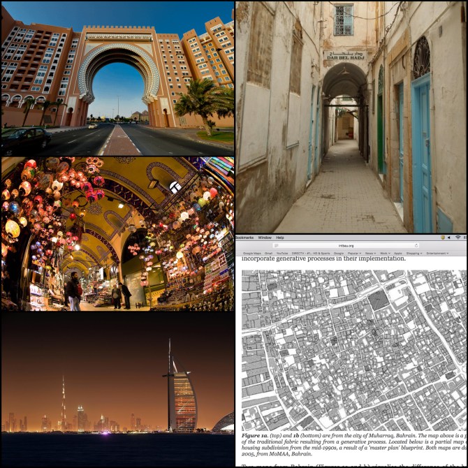
Buildings like these are the kind that could be found in dense, often unplanned cities like those in the image of the map in the lower right. Since the caption on the image suggests that it is a map of Bahrain, the area undoubtedly experienced a high rate of urban growth which would explain why parts of the city fabric appears to have a bit more regularity.
The city appears to have expanded, or grown around the historic core thereby preserving it. The new city areas of the city, which are likely the direct result of financial influence, would, like the Burj, help to delineate the line between the rich and the poor.
-Tamara Stuart
Very nice, very thorough, good work.
The cities in the Middle East and northern Africa vary wildly in size, architecture, wealth, and population density. The first photograph at the top left is of the Ibn Battuta Mall in Dubai. This is a very modern and extremely wealthy city. This building specifically is the largest themed shopping mall in the world. Very little of the modern city of Dubai has been preserved or is modeled after the old city. However, the part of the mall that bridges across the street in the photograph does look quite a bit like the dome from a mosque, referencing the heritage and religion of the people living there.
The photograph at the top right is of the Medina quarter of Tunis, Tunisia. This area was made UNESCO World Heritage Site in 1979. This means that this area has been made to stay exactly how it’s been for hundreds of years, and is a prime example of how cramped the living spaces were for people of older cities. Although this specific photograph is of a historically significant and preserved area, the rest of the city has changed and grown around it significantly. Although the surrounding city is significantly different to the area in this photo, this area will always be preserved as a reminder as to where Tunis, Tunisia has come from, and serves as an architectural reference point for the rest of the city.
The photograph in the center left is of the Grand Bazaar in Istanbul, Turkey. This structure is one of the largest and oldest covered markets in the world, dating all the way back to the 15th century. Architecturally, this is an example of one of the many types of architectural styles found in Istanbul today (in this case, an Ottoman architecture), and although it is a very old, it still serves around 250,000 people daily (90+ Million people per year). This market has been wonderfully preserved and has served as a model for large covered markets for centuries.
The photograph at the bottom right is of the old town of Maharraq, Bahrain. This town has morphed into a large city, which is currently the third largest city in Bahrain, and served as its capital until 1931 when it was replaces by Manama. This photograph specifically shows a map of the old town, rather than the modern city. This old town was created in a much more organic way, rather than a modern, planned, gridded city. Since this is not a strictly Cartesian, grid-like city, it actually has quite a high density of population, but does not meet the requirements of modern –day living and transportation. Since Bahrain is an island, living space is limited, and that means that many of the places in Bahrain that once were laid out in an organic way, like the area shown in this map, have since been replaced by much more modern gridded city layouts.
The photograph at the bottom left is of the coastline of modern Dubai. Pretty much everything in this photograph has been constructed since 1990. Almost nothing in this photograph really harkens back to the old city of Dubai or the architecture associated with the rest of MENA. This photograph really shows what having billions of dollars from oil money and not knowing what to spend it on will do for you. The architecture of modern Dubai is absolutely incredible, completely modern, and of a style like nowhere else in the world.
Excellent/
Given the photographs and map representing the new and old urban forms of the Middle East and North Africa it is evident that modern architecture pays homage in some aspects to the old and traditional forms. While the original urban forms depicted in the photo and map, on the right, are born from necessity the new form, images on left, clearly still share some design characteristics. This is because cities in the Middle East and North Africa have had many conquerors and colonial occupiers, both Islamic and European. And with these occupations the urban form and architecture have shifted to fit societies’ tastes and needs. Modern developers then aim to recreate these urban forms to carry on some tradition while augmenting where necessary to fit with modern aesthetics and building.
The top left photograph depicts a modern large multilevel dwelling, possibly an apartment complex or hotel, with a massive arch in the center spanning a four lane road. Preservation of the old city aesthetic is evident from the giant arch as well as the smaller decorative arches on the bottom of the building. The original urban form is also exemplified by the crenellations on the top of the arch. These crenellations initially served as defense when initially implemented into the Middle Eastern and North African urban form. Now they simply serve to preserve the traditional building look and design.
The top right photograph is of an old Middle Eastern and North African urban form. It shows a narrow ally with an arch supported building partially overtop. This photo exemplifies the old urban form born from necessity more than the wish to preserve traditional form. This is apparent from the relative closeness of the quarters. Because the city is size limited urban dwellings are multilevel and span over roads. However other urban form functions are also visible. For example the road cannot be entirely built over because the road cleaning depends on rainfall. The door spacing also serves a function. They are staggered from their across neighbor to maintain privacy which is extremely important in Middle Eastern and North African religions and cultures.
The middle left photograph illustrates a Middle Eastern or North African bazaar. Once again the new form closely resembles that of the old, with the long arch structure of the market and the smaller arch motifs throughout. This attractive market keeps to the traditional form and function, which patrons appreciate. This ensures that smaller marketplaces such as this continue to thrive and play an important role in Middle Eastern and North African cities.
The bottom right map portrays an aerial view of the city of Muharraq in Bahrain. This map typifies the irregular building and urban form of a growing city. There was clearly little city planning and no real grid system to speak of, other than the chunk of city being surrounded by a relatively regular rectangle of large intersecting roads. This city section probably developed its urban form by originally being on the outskirts of the city and people would build a home for themselves on the best land they could find that someone wealthier hadn’t yet wanted to build on.
The final photograph on the bottom left is of a very modern Middle Eastern or North African skyline with many skyscrapers. This modern urban form of showing vast wealth is newer to the Middle East and North Africa however there was extreme showings of wealth and power in the old urban forms as well, just without skyscrapers. The high-rise in the forefront does however show a little of the traditional form, with its long rounded shape on one side, similar to the ubiquitous Middle Eastern and North African arch.
-MH
God, well thought out and thorough.
The old cities of the Middle East and North Africa have been preserved and modeled in the new urban cities in various ways, shapes, and forms. For example, the photograph in the upper right-hand corner displays one of the main characteristics of the urban city form, privacy. Taken in Tunisia, the housing doors are offset from one another so you cannot see inside, and the windows are kept above eye level so that people passing by cannot look in. As these houses are fairly small, by building over the alleyway, people can add much needed space to their homes while maintaining a functioning alley.
Istanbul, Turkey is a good example of how the older values have been transformed to fit the needs of the urban society today. The middle, left picture is of Istanbul’s Grand Bazaar. As one of the largest and oldest markets in the world, this indoor facility has been a common trading spot for centuries. Although this market is very old, it has been modified with modern technology such as electricity to allow people to buy, sell, and trade their goods.
Dubai is a state that has allowed its modern day technology to flourish and deteriorate their old urban style. Shown on the bottom left, the modern day coastline of Dubai has flourished into an absolutely stunning lifestyle, leaving behind their old urban city system. Dubai has preserved only small amounts of their old city and with large amounts of oil money funding the state, this type of massive architecture and development is becoming more common in the gulf. A style that is not seen throughout the world, Dubai has made itself a state to be recognized by its wealth and impressive architecture. The photograph on the top left is also from Dubai. The Ibn Battuta Mall is the largest mall in the world showcasing vendors of all different categories. It expands over two blocks and houses the most expensive designer brands. The state has tried to keep the culture in this mall by the architecture and designs on the outside, but ultimately preserving the old city form is not a priority in Dubai.
The map on the bottom left is showing the old town form of a modern city in Bahrain. With a large population, this city does not meet the standards of what we see as a modern day city. The map shows that the city does have courtyard housing and has been quartered off by roads. Within each of these quarters there are specific services such as a mosque and the open spaces are assigned to the interior areas of a home. Newer urban forms have been developing outside of the old city form, which has allowed Bahrain to maintain their old city style.
As some cities of the Middle East and North Africa have been preserved and modeled in the new urban cities, some cities have not. I feel that the more wealth a state has, the more altered their old urban system is. However, the cities that do not have the ability to change their urban development are more inclined to keep the old city in tact. This proves true with Dubai as its wealth has diminished its old urban city form
Very nice discussion.
It’s very well known and it was also said in class the majority of the countries in North Africa and the Middle have an urban configuration and design that was first created by the Ottoman Empire and latter modified by the European colonialists. In the old building that portrays a two story apartment or house, it can clearly be seen the representation of the ottoman influence. Some of the Ottoman traces represented in these complexes: back then the houses were built with two stories. The idea of building two story houses or apartments lies in the fact the first floor of these complexes was used for women to gather in order to socialize with other women. The main intention of this practice was that women were able to socialize without being seeing by men. Another feature represented in these complexes, that can be seen in one of the pictures, were the height at which the windows were built. These windows were built at a height superior to that of a human so that a person was not able to look inside. Something by which these houses are characterized also is the way the doors are placed along the streets or hallways separating the complexes. If you take a look at the picture these doors are never placed in front of each other, each one of them are facing a piece of wall.
It is interesting to see that the Middle Eastern urban areas are one of the fastest growing in terms of modernizing their infrastructure through the creation of buildings. However, most of what once was the citadel, the public markets (like the one in the picture) and the mosques have been preserved. This sense of preservation comes with the value that these places represent for their culture.
The picture that represents the city of Muharraq in Bahrain, for what I can tell, shows little or severe signs of urban growth and I would even dare to say signs of urban sprawl. Urban Sprawl is very common in Middle Eastern countries. Some times that growth contains residential areas that are not well designed and planned. In some countries we can see how one house is built on top of the other by the same owner. In the majority of the cases the next house built on top is built to accommodate an owner’s family member, who usually is a son or a daughter. This practice is very common in new residential areas because the owner does not have to pay taxes until the house is finished.
Oil was one of the natural resources that attracted the majority of the European colonizers that arrived to Middle Eastern countries. Is that same resource the one that is financing the growth of urban cities in some Middle Eastern countries and the majority of the countries in the Gulf States. These countries have produced so much revenue as a result of the exporting of oil that they invested it in the construction of buildings and new exclusive residential areas. Some of these residential areas have palm tree shapes that can be observed from space. The expansion of these urban metropolises has required the input of foreign labor from other areas such as Pakistan. The migration of this labor has lead to the creation of residential areas to accommodate these workers. Some of these residential areas have been planned others have not.
Good discussion.
Thanks to the massive influx of oil money beginning in the twentieth century, the urban form of the Middle East has changed rapidly in recent decades. These images show both the changes and the continuities in the region’s urban form. The images on the right depict more traditional Middle Eastern urban morphology. The bottom right image shows a traditional residential zone. Traditionally, residential zones were based on the courtyard system and were very crowded. Several buildings would open onto a common courtyard area. The buildings would be 2-3 stories tall, with women confined to the ground level and men on the upper level(s). Residential privacy was maintained by generally limiting windows to the upper floors; windows on the ground floor would be covered by shutters. Doors into residences were offset (i.e., not directly facing each other) so that you could not see into your neighbor’s house if both doors were open. The residential zones also featured a system of alleyways between buildings that were two camels wide to facilitate transportation. Buildings would often feature ‘bridge’ rooms over an alleyway. The top right image shows many of the stereotypical architectural features. The offset front doors and ‘bridge’ room over the alleyway can be seen, as well as the limited use of windows.
The images on the left all show more modern urban forms. The top left image, of Ibn Battuta Mall in Dubai, shows how modern buildings, while completely different than traditional ones, can still preserve some more traditional elements. The exterior of the complex, shown in the image, features classic Middle Eastern architectural elements, like the arch, which also serves as a ‘bridge’ over the street below.
The middle left image is of a spice market in Istanbul. The souq or bazaar was very important to the traditional Middle Eastern city. The souq/bazaar would be very close to the citadel at the city center, where it could be accessed by all residents. Even in the era of shopping malls, the marketplace has persisted as an important part of the Middle Eastern city. They may be updated with different goods and electricity, but they still serve their original purpose as a center of commerce for the people.
The bottom left image of the Dubai skyline truly shows how much has changed in the region. Less than a hundred years ago, Dubai was simply a small village on the Gulf. Today, it has grown into a major metropolis, transportation hub, and even tourist destination. Dubai’s explosive growth was funded by oil and allowed the construction of iconic buildings, like the Burj al Arab and the Burj Khalifa in the image. However, unlike neighboring Abu Dhabi, Dubai’s oil resources are quickly dwindling, and its leaders are trying to make Dubai a tourist destination so that the wealth of the Emirate will be maintained in the future. While it seems that such extravagant buildings in the skyline can have no connection to the traditional Middle East, but the Burj al Arab’s design was in fact inspired by the sail of a dhow, a type of sailboat used in the region for centuries.
Thank you, Matthew, always excellent.
The Middle East and North Africa, or MENA, region has a long history and contains some of the first urban cities. This area was frequently conquered by many different types of civilizations throughout time including Greeks, Romans, Ottomans, Europeans and many more. However, the region has maintained some distinct urban characteristics even under many different rulers. Some common architectural forms of the Middle Eastern and North African cities include the arch which is shown in the top left, second left, and top right photo. The arch has been used for thousands of years and continues to make appearances in new urban architecture. Most of the MENA cities also contains mosques, citadels, markets, and residential areas. In the left middle picture we see a market, also called a bazaar, featuring the arched ceilings. These markets appeared along trade routes as a place to meet and trade, haggle, or buy goods from around the world. The success of a bazaar often times led to the growth and power of a city because the more people that came to an area to trade the more people would come to live here as well. As population grew from richness of an area the urban city began to form. The older cities like present day Istanbul or Baghdad created and maintained cisterns, an underground storage to collect water. These can still be found today. Another urban form due to population growth was the narrow street ways seen in the photos on the right and often found in residential areas built wide enough for two camels to pass through. Also pictured in the top right photo is how the residential areas typically worked with offset doors and windows on the second floor. Because women lived on the first floor windows were either not made or were covered. In the older cities the city plan was fairly tight and unregulated due the quick growth so roads were often irregular.
All these urban forms have stuck with the culture over time. The MENA region kept growing and cities became tighter with denser populations. Some areas could financial handle the growth while others could not and have become poor or run down. In the Middle East, the Gulf States struck oil and have developed quickly with the massive amounts of cash revenue coming in. The Gulf States are richer than they know what to do with the money and so they’ve built sky rises like pictured in the bottom left. Unlike the rest of MENA I feel like the Gulf States have lost touch with the old urban form and theirs is the most different from the rest of the region due to the wealth of the cities here. Over all the Middle East and North African regions maintained their dominant Roman and Ottoman urban styles but also incorporated architectural influences from Europeans and more recently Americans. The MENA region is like the crossroads of many great empires, always growing and changing with time but also holding on to their deep cultural roots.
Jessica Nelson
Good discussion.
The Middle East and North Africa cities are based off of a central place of worship and marketplace. The tight clustering of buildings put a premium on full use of available space. This is evident in both the old and new city structures with space above roads and allies being utilized for crossover bridges or living space. The architectures outward cosmetic look is different than the European cities but at the same time structurally very similar. The shared full utilization of space is seen in both old cities of Europe and the Middle East. The newer buildings in the region also share traits with the western and modern European cities. The distinction of middle eastern cities are in the use of their arches as well as the obelisk like minarets associated usually with mosques as seen in the lower left picture of Dubai. The older pictures on the right if devoid of any writing or signage could easily be mistaken for old European cities. As with the previous post of the middle ages city structure, there is a congestion seen with use of all available space including the area above walk ways. Also much like the middle age castle cities of northern Europe the close proximity with central roadways allowed for a better defense of the inner cities. A key structure in Middle Eastern cities as compared to the European ones of the time was the central marketplace as well as the citadel. These central aspects can be seen both in the historical and modern depictions of the cities. The indoor marketplace can easily remind those looking at it of the same marketplaces of history. The clustering and concentration of residents of the cities also has remained with little changes. Making full use of the available space the cities have embraced the idea of the western world to expand vertically. The towering sky scrapers are a modern turn on the idea to fully use the space with shops below and residences above. The modern Middle Eastern city also complies with the age old system of segregation. The cities not unlike many others elsewhere with in the region and the world maintains the separation of the haves and the have nots. The influx of massive wealth due to the oil reserves of the region have allowed this to manifest itself by way of the new lavish buildings. The separation exists more between the locals and the imported labor forces. Where the locals will often construct prison like communities to ensure the workers are located separately from the upper-class local residents. While the size and the lavishness of the structures and cities has grown in the region the common themes and designs have maintained.
Good discussion.
The old cities of the Middle East and North Africa were built for the most part out of the necessity for port and trade centers. These cities did not have much in the way of urban planning and typically grew organically. They had very large agriculture and market centers for buying and trading goods. These centers eventually evolved into covered markets. Which is very unique to the middle east. These cities were built with a predominantly Muslim population in mind. Utilizing Arabesques, calligraphic inscription, and domes unique to Islam. Like in the top right photo, the doors are arranged in a way that it does not allow prying eyes to see into the house from the other house doors. Also windows are not at eye height so as to not allow sight from the street into the homes. This style is often referred to as the “architecture of the veil”. This is because the style values the beauty that lies within, that is not visible to the outside world. Thus an emphasis is put on private courtyards and gardens that are not visible from the streets.I actually find this quite poetic. Mihrabs are also common among this style of architecture. These are a semicircular niches in the walls of mosques and are used in indicating the direction to Mecca. Each time one of these cities was conquered by a new ruler, that ruler would usually add on to the existing city trying to leave their mark. Or they would build religious temples and statues promoting the religion of their culture.
Modern MENA architecture has evolved drastically over that of the older more organic style of architecture and planning. Today the architecture and planning resembles that of Western architecture and planning while still holding onto many of its Islam stylistic roots. Many of the modern cities have still found ways to incorporate the covered agriculture and market centers. Much more attention is put into urban planning within modern cities that are growing rapidly, such as Dubai. Cities like Dubai are popping up all over the middle east due to the excess of oil money. They tend to showcase the flair of the “spare no expense” attitude of the rich. The Burj Khalifa(can be seen in the skyline of the bottom left photo) is a testament to this with a hefty $4 billion dollar price tag. The Burj Khalifa is the world’s largest building and rises from a base that is shaped to look like the flower hymenocallis(a white lily found in the surrounding desert). The Burj Al Arab(the sail shaped building in the forefront of the bottom left photo) is another world renowned building housed in Dubai with a price tag of $7.8 billion. The Burj Al Arab is luxurious hotel that rests upon its own man-made island. The Burj Al Arab was designed to resemble that of an Arabian dhow. The hotel is notorious for housing the world’s largest atrium on top of 8,000 sq meters of 22-carat gold leafing.
-Jonathan Bartlett
Good discussion.
Middle East and North Africa
Many cities in North Africa were formed during the colonial period. They were colonized under both Christian and Islam colonization, which makes this area very peculiar in their society and architecture styles. Inland and coastal cities were a function of trade with Islamic countries. European involvement started along the coast with small outposts that eventually grew to cities. Once they put in railroads they started to move inland to set up trade routes. Middle East cities are obviously much older and developed under Islamic rule and architecture. The main areas of development were in the area of the Fertile Crescent. This area is one of the oldest areas of development in the world – with the development of city-states, civilization, and technology.
The top left picture is a modern building that is designed with typical Islamic architecture. The crescent shape of the opening and the parapets along the roof are an example of this architectural style. The crescent opening is also adorned in blue and white ornament that is typical with Islamic design as well.
The middle left picture seems to be in a bazaar located in an Islamic region. The curved roof and small windows are commonly located in the Middle East or North Africa as the windows allow in natural lighting but aren’t big enough to heat the interior much, so it stays cool inside.
The bottom left picture of a Gulf State. These Gulf States are rapidly urbanizing and growing into megacities due to an increasing sense of globalization that society is in today. These cities are able to grow very fast and very modern due to the rich oil fields found in the region that the oil sheiks own. These cities are built by migrant workers from SE Asia mainly, and housed in dorm-like housing complexes that are often under guard.
The top right picture is a typical side street in these old cities. They are very narrow to allow for as many houses as possible to be included in the city. They are wide and tall enough to allow for a camel to pass through them, as that was the main mode of transportation back when these cities were at their height. The covered area in the background is an addition to one of the houses. If you need more room, you just build over the alley as long as you make it high enough off the ground.
The bottom right picture is a plan view of a typical city found in the Middle East or North Africa. There are main streets connecting the city together along axis lines and small side streets that connect all the housing units. They try to fit as many units into the city as possible with small single-family housing.
good discussion
The old cities of the Middle East were very elaborate with long, thin, windy roads and paths throughout, a mosque, a madrasa, a covered market, and a residential quarters, oh and a big iron door, that’s important. The modern city in MENA varies very much geographically. In Palestine, the old cities are small and maintain their old historic character, while plastered with electric signs and new metal gates drilled into walls, but other than that, not much has changed (of course except for the addition of electricity and other modern comforts). Outside of the old city is often a circle with a big fountain or statue that marks the city centre from which the rest of the streets branch off. Ramallah is the master of connectivity– there are rarely dead-ends, as intersections are often made up of circles which lead to other circles. Traffic is only bad near checkpoints and at the center circle. Jerusalem is a wild city that has maintained its old quarter very well, but has grown to include tightly designed building to run along the hills around the city, radiating out in a fan-like direction to the West of the old city. Bethlehem is a great example of a modern city that has remained very, very much of its old character. Bethlehem is centered on a very steep hill, and the old city is elaborately filled with massive staircases and tiny paths, but the interesting thing is that much of the roads are also very steep, windy, and skinny, just like much of the old paths. The buildings are stacked for housing efficiency in the same style as in the old city, and there still remains that confusing connectivity that characterizes the MENA old city. Oh, and the big iron doors are everywhere, even on the modern built houses. But even within Palestinian cities, there is still wealth segregation. Just in the way there are suburbs here, there are gated Palestinian communities too. The communities have a gated entryway leading to large, luxurious villa-style homes. But before I start talking about Israeli cities and the architecture and urban planning of control (which would be an interesting conversation to have [thank you, Oren Yiftachel]), I should discuss the developments in other cities.
Tehran is a massive, sprawling metropolis, but still maintains a lot of its historic architecture and color.
I would like to take a moment for Sana’a 😥 the beautiful city maintaining so much of its historical architecture and color and design, now shelled by Saudi Arabia to only be appreciated in photos.
The large metropolises of Syria – Damascus and Aleppo – maintained large, European style road design and wide central roads outside of the old city, filled with beautiful thriving markets, but now subjected to horrid destruction at the hands of Assad.
The famous Gulf cities of Dubai and Abu-Dhabi, and even Kuwait City have either very tourist-driven old cities, or none at all. These cities, like Riyadh too, are very modern cities that exhibit the power and modernity of oil wealth in their architecture.
The larger cities within Morocco, Tunisia, Algeria, and Libya are some of the best examples of the old city with a modern city built around it, and in particular, the city of Algiers. The modern city of Algiers was built entirely outside of the old city as a way to take control of the population by providing wide, long, totalitarian-style streets that allow surveillance to be integrated into the lives on the prospective French colonists. The Modern city, like many other in the Middle East, reflects the old city layer, the colonial layer, and the modern layer. Algiers is a wonderful example of this.
Good observations, especially about Sana’a