Discuss the way in which GIS (remote sensing, map compilations, satellite imagery etc.) has changed the way in which we see the world.
Discuss the way in which GIS (remote sensing, map compilations, satellite imagery etc.) has changed the way in which we see the world.

GIS (geographical information system) technology has expanded the interpretations of the Earth horizontally, vertically, and indefinitely. Applications are endless, and some practices include the creation of topographic maps, water reservoirs modeling, data analysis, street and address maps, and mine prospecting. Virtually every concept can now be mapped in a 3D interpretation, and then spliced and layered for a more comprehensive understanding. Time can also be applied to these interpretations, such as the complete history and evolution of the Zaire deep sea fan delta on the Congo shelf.
GIS made the world considerable smaller and easier to fit onto a computer screen. It has taken our knowledge of the world off the paper map and has added the index of time, which allows GIS operators to correlate information that would otherwise have no connection. Topographic maps, satellite imagery, latitude, longitude, time-space, and elevation can all be brought together to have a better understanding of spatial relationships.
From a Geological standpoint, GIS programming has been invaluable. Practically the entire Earth, above and below water, has been mapped and analyzed. The analysis goes beyond the crust as well. Drilling and tectonics are just a few of the geospatial applications that play a key role in the world economy. Oil and gas prospecting and drilling has become increasingly efficient due to our ability to map and understand the subsurface.
A more complete understanding of the tectonics of individual regions has allowed for increased risk awareness and mitigation. Information obtained through GIS about real estate cite selection, evacuation routes, and evacuation planning has contributed to a significant decrease in death and damages in many hazard-prone areas around the world. One such example is GIS involvement in Taiwan’s preparedness for typhoons. GIS technology allows disaster researchers to study all past typhoons, as well as equate time to current rainfall, water level, and forecasted typhoon paths. These points all come together to give people around the globe a better understanding of when and how natural disasters will affect civilization.
Any data points entered can be correlated in a multitude of ways, and these applications go beyond the physical Earth. Distribution of population, ethnic groups, cultural subdivisions, and water pollution concentrations are just a few examples of the ways GIS can be applied in a geographic way. GIS technology has allowed us to sew together fragments of the world into one cohesive picture.
The spread of disease can also be mitigated by GIS. An epidemic can be stopped from devolving into a pandemic by studying the pathways in which disease has spread out of an area in the past. This data is applied to current disease spread, and the prediction and occurrence of outbreak is much better controlled in sufficient time by using GIS.
GIS allows multiple layers of information to be displayed on a single map. Because of this layered affect, GIS is highly useful for analyzing, interpreting, and seeing relationships on a world scale. A wealth of information is available to be analyzed and benefited from with the help of a geographical information system.
http://www.esri.com/what-is-gis
http://www.esri.com/news/arcnews/fall11articles/disaster-decision-support-system.html
https://www.nationalgeographic.org/encyclopedia/geographic-information-system-gis/
https://www.gislounge.com/what-is-gis/
Very nice.
Only a few hundred years ago, our only perspective of the earth was from what our eye could observe. Cartographers such as Ptolemy and Fra Mauro spent their whole lives researching and studying what we now can learn about in an instant through outlets such as google maps or satellite images. Today, GIS allows us to study the geography of the earth in a much more detailed way, with multiple points of perspective. The first satellite image of earth was taken on August 16th, 1959, and opened a door to a brand new perspective of our earth.
GIS impacts our everyday lives through the use of GPS, an atlas, or sharing your location with your friends and family on your iPhone. Now we can know exactly where we are and how far away a certain spot is within a few seconds, and get directions there as well all with the click of a button. This is much different from the world 200 years ago, where maps were constantly changing and only in a two-dimensional form. In addition, in order to read a map you must have a compass as well and some basic knowledge about mapping. As a person back then, you saw the world as it was in front of you or as any glimpse of a map you might have seen while today when one pictures the earth they may see many different images including the famous “blue marble” taken by the Apollo 17 crew in 1972. Needless to say our perspective of earth has completely evolved from its primitive state.
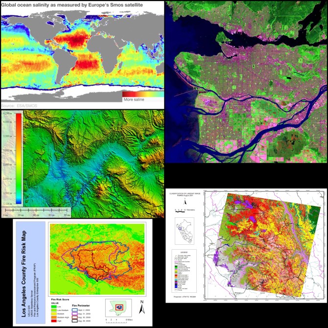
GIS has allowed us to use remote sensing to track tropical storms, earthquakes, and erosion and create preparedness strategies from the data collected. Remote sensing can also be used for things such as monitoring ocean temperatures and wave heights, chart wildlife habitats, map coastal features, and track sea ice. On many weather reports, satellite imaging may be used to show weather systems moving across land, which would be impossible without GIS.
Good, but brief.
GIS, better known as geographical information systems technology, has changed the way we see the earth in numerous ways. Through the help of these systems we can now see the earth better horizontally, vertically, and dynamically over time. Using certain constant data points like latitude, longitude, elevation, etc. GIS gives us the ability to predict, and analyze spatial relationships involving more complicated matters over a period of time. The ways in which we can use GIS is astounding and almost limitless in applications. Some methods involve the use of dynamic maps, data analysis, street mapping, and resource mapping. Almost any concept can be compiled into a 3D model. Information can be correlated to create spatial relationships with several variables like elevation, time, satellite imagery, and numerous others. Geologically it is indispensable, as the entire globe of earth has been mapped out from subsurface levels, to atmospheric levels. We can monitor the fluctuation of bio systems, climate, and these geospatial applications help us analyze our efforts to preserve the earth’s natural beauty and cultivate biological life. It also betters our economy as oil and gas can be mined more efficiently now that we can understand and directly see certain reservoirs. This again lowers the overall radius that is affected from the detrimental effects of natural resource extraction. Tectonics as well can be analyzed allowing for better predictions and preventive actions against earthquakes. Furthermore, GIS acts as a phenomenal tool against natural disasters, increasing the awareness and knowledge of certain natural phenomena like weather patterns that dictate typhoons, rainfall, mudslides, etc. Weather can be monitored better than ever, allowing us to predict and map any patterns that we choose and preserve suburban areas. Inhabitable lands can be mapped out, and potential real estate can be efficiently graphed to efficiently use space solving problems of overpopulation. This data is used in a multitude of ways, and physical attributes are just the beginning of what GIS can interpret. Demographic relations as well can be viewed in terms of culture divides, population distribution and disease potentiality. Epidemics are understood substantially more than we could before, and this allows for yet another benefit of preserving society. GIS essentially takes layers upon layers of information, and can cohesively provide a 3D map model of literally any subject that is needed. Being able to see relationships on a world-wide scale and understand several factors that effect society like, weather, disease, and economy, has given us an advantage in preservation of our planet, but also in mankind as well. This further benefits our economies, public health, and disaster prevention efforts. GIS is astounding in its usefulness, giving us an abundance of information that can be used endlessly for years to come. This technology has caused a revolution in what we can do for the public and planet earth, and roughly every profession benefits from GIS’ new technologies. Thanks to GIS several other technologies have branched out and benefited from the innovation. GPS for instance adds yet another layer to the mix, giving us an enormous understanding of space in terms of ourselves relative to each other, and major landmarks of the world. GIS arguably has become the largest vessel for mankind understanding ourselves and the world we live in.
Sources:
http://gisgeography.com/100-earth-remote-sensing-applications-uses/
https://www.aaas.org/content/what-are-geospatial-technologies
Good discussion
Geographic Information Systems, or more commonly known as GIS , is a computer-based tool which helps in analyzing, storing, manipulating and visualizing geographic information. This is extremely helpful in our modern more technological era and is a far cry from when people first believed the earth was flat, and that natural occurrences were thought to be random events. GIS is helpful and is required for so many disciplines that help the everyday person without them even knowing what the term is. Every single map on the internet that is used by people has date stemming from GIS. Without this data, the maps of the world would be highly inaccurate and harder for anyone to use. GIS gives a more comprehensive data set than just that for mapping purposes. It provides an information structure that can be used for spatial analysis, meaning that areas such as climate change, natural disasters, as well as population dynamics can be analyzed faster and more accurately. Historically, the first recorded use of GIS was by a British physician by the name of John Snow, who noticed a correlation between cholera victims in London, and their proximity to water lines. This helped him to make the guided assumption that cholera was linked to public hygiene, or lack thereof. Today, GIS systems are an integral part of our daily lives. From utilizing Google Maps, to checking how a particular product is doing in any given region, there are many individuals and companies that use these various systems. Combined with the dimension of time, GIS provides valuable information for environmentalists because it provides all the information that they require on one highly interactive platform. The same holds true for agriculture, forestry and deforestation. GIS is also crucial for urban development, in terms of real estate, land planning and surveying, and for targeting specific clienteles. One other sector of our modern and global world that utilizes GIS is that of the military. Throughout history, decisive military campaigns have always been carried out with the input of the environment and the topography. This is even more prominent today, so as to guarantee the success of any endeavor. GIS is a very powerful tool and analytical process that is more significant for us than a mere mapping algorithm. It has enabled the world to be looked at on a larger scope and scale that allows us to see the underlying patterns that are apparent throughout history. Often these underlying patterns can provide a means of better prevention and mitigation, especially in the case of natural disasters. This then leads us to learn from our mistakes as a species as well as to improve our way of life. GIS is also prominent in our society because of the advances in technology that occur every day and will become more specialized because of the input from this geospatial tool.
Source
http://gisgeography.com/what-gis-geographic-information-systems/
Nice work
Imagine living in the colonial era, where in a lot of ways you could only imagine what other parts of the world were like. People relied on maps from explorer that basically gave a general understanding of where major rivers were and the shapes of continents but we didn’t know what species lived where or where the best place to build a house would be. But now we can answer all the unanswered questions of maps, and that is because of the revolutionary invention of GIS. And oddly enough, today (11/19), is GIS day, so make sure you celebrate! By the early 1960’s technology had evolved enough to where we had very accurate maps and understanding of the world, but there was still so much that conventional maps couldn’t tell us. During this time, a Canadian company developed GIS technology in order to improve urban planning and design. People then began to realize this technology could possibly change the way we look at the world, and now we didn’t have to rely on human collected data from the field to get the data we wanted. Instead, we could cross reference certain geological states in order to collect data on species and find very useful data to help with understanding the world and its species. Another interesting part of this technology is that it was invented long before computers became a thing. At its roots, GIS was simply stacking maps on top of one another in order to make statistical analysis much easier, since we could now cross reference a bunch of different aspects of maps all into one database. This can be seen in rural communities who make maps of good places to hunt but also take into account how to balance that with the natural resources surrounding them. But with the introduction of computers, now this technology could reach its full potential. Instead of just taking into account two or three maps stacked of an area, we could now take into account 100’s of different variables in order to be much more effective in our geological tasks. Effectively, what GIS does for us is instead of looking at a piece of land for its location, we can now take into account way more than just location. For example, a real estate company wants to build a new sub division. Before GIS, the company would simply look at nice pieces of land maybe not too far from town that could suit their needs and build away. But now we can look at that same piece of land and using different findings we can get a deeper understanding of the wildlife nearby or where they could build without harming the natural resources in the area. This allows us to be more efficient as a human population and have a better grasp on where we are living. We can better control conservation and look at the land for what it is made up of and what lives on it rather than just simply where it is located.
http://www.fauna-flora.org/more-than-maps/
Good but brief
GIS, or geographic information system, has revolutionized the way modern humans view the world. It allows us to understand and analyze the different layers and features of the world that can not be seen through normal mapping procedures, and opens the door to better understanding the ways in which planet earth works.
One great feature of GIS is that it offers interactive maps of almost anywhere you could need to know about. For example, I found many interactive maps of Fayetteville, which allow for me to see anything from the school zones of the city and historical sites around Fayetteville to the places most likely to flood in Fayetteville. This information can be used for a number of different reasons, be that to choose the best place to build or buy a house, the best places to take scenic pictures, or simply where to find free parking. The usage of GIS can greatly help the everyday person learn their surroundings, and help them to orient themselves in a foreign place.
GIS can also be used on a grander scale to help cities and states operate smoothly. For example, a GIS showing the times when cities streets are most congested can aid a city into knowing the best times to clean the streets, and maximize their profit by not wasting gas and energy. Similarly, GIS has allowed the country of Taiwan to map and anticipate typhoons, and make efficient plans to mitigate the impact, and evacuate their citizens from danger zones. In this way, GIS has allowed for a more efficient and well run human experience.
GIS systems are also widely used in urban planning, and mapping the best ways to design a city and its outlying areas. The usage of GIS allows for the most efficient and organized city technology can manifest, all which remaining accessible to the average person. One of the most useful features of GIS is that it allows for multi layer mapping, in which many different ideas and concepts can be demonstrated in one map, making planning much more efficient. For example, layering a map of land prone to erosion over land prone to floods can tell a developer where danger spots are, and where to build that is both the safest and most profitable. Furthermore, GIS engineers are now beginning to think beyond the realm of 3D mapping into the emerging possibility of 4D mapping, which will again greatly alter our city structures and world in a way that is not yet fathomable.
Another great use for GIS is in the technology industry, in which it can be used to map service areas and wireless coverage zones. This feature is useful for both telecom and network companies, who can use this to see spotty coverage areas, and technology users, who can utilize GIS in order to see in what areas they are covered while traveling.
The usage of GIS technologies has greatly altered both the ways we view and the ways we interact with the world around us. It has lead to innovations in mapping and viewing different facets of our surroundings, and holds the promise of continued innovation as GIS technologies evolve.
http://www.esri.com/what-is-gis
http://www.fayetteville-ar.gov/384/GIS-Interactive-Maps
http://gis.usc.edu/blog/why-is-gis-important-in-urban-planning/
http://grindgis.com/blog/gis-applications-uses
Nice work
GIS (geographic information systems) is a type of mapping technology that infuses different data into a geographically defined space. GIS, otherwise known in its simplest form as “computerized mapping,” has deeply affected our lives and the way in which our species is able to view the very planet that we walk along every day.
GIS is said to have begun in 1854, when John Snow made a map of cholera outbreaks in London to try and trace the disease back to the source and put an end to whatever was causing the massive outbreak. By his use of “GIS,” (before it was commonly referenced as such) putting geographic layers on a paper map, he was able to save many lives. This kind of haphazard mapping of different data points and geographical landscapes continued through the 19th century and into the 20th, where road maps began to become much more sophisticated and formal. Still, though, trying to layer information onto a physical copy of a geographical area came with many complications, such as the trouble many researchers had with calculating areas of a region or just simply measuring distances. These computations were inaccurate and unreliable more often than not, which led many people on a hunt for a simpler way to make these charts and maps and be able to attain data from them without having to depend on the human brain, which as most of us know, is very prone to error, especially on something with such minute details as computing the area of a land mass.
Then, along came a man by the name of Roger Tomlinson, who is often referred to as the “father of GIS.” Tomlinson was director of the foundation of the Canadian Geographic Information Systems, which was special and new because it utilized a layered approach system to mapping. This led to the establishment of the Canadian Land Inventory, which was a geographical map that layered many different data points (soil, drainage, climate characteristics, and more) to determine what part of Canada was the best for planting different types of crops and forested areas. This work inspired the United States Census Bureau to found the basis of digital map inputs, which allowed for data to be placed over certain areas, and also allowed for computerized computations of things such as map area and distances.
Along with the new digital maps, satellite imagery and remote sensing came along and allowed researchers to place images over digital but conceptual maps to make them as realistic as they could be. Also, many other applications of the satellite imagery and remote sensing have emerged since their foundation, such as
• Being able to view Earth’s surface elevations at all points on a map. This type data was generated from the Shuttle Radar Topography Mission, which was a mission that sent a very specifically modified radar sensor type system that flew along with the Space Shuttle Endeavour that was actually able to sense and record the topography of almost all of the Earth’s surface
• Being able to view different factors of the surface of the Earth, such as when remote sensing is used to plot locations of mineral deposits
• Being able to mitigate disasters with risk assessment images, and being able to acquire damage assessment data quickly after a disaster has struck
and many, many more. Geographic information systems are vital in the geographical mapping of data, which in turn helps societies view different maps and areas to assess the information that the maps are providing and make changes because of this. GIS was able to turn physical geography on its head and make a map about much more than the physical landmarks and the roads that run through it; with GIS we are now provided a means for measuring and analyzing properties of a specific area and making changes thanks to the gathered information.
http://www.esri.com/what-is-gis
http://gisgeography.com/history-of-gis/
https://www.thoughtco.com/how-is-gis-used-today-1434620
https://www.gislounge.com/five-applications-of-satellite-data/
http://www.ceinsys.com/blog/applications-of-satellite-imagery-remote-sensing-data/
https://www.environmentalscience.org/agriculture-science-gis
Excellent
Since the introduction of Geographical Information Systems (GIS) in the mid 20th century, the collection and analysis of data of the physical world has been revolutionized, allowing humans to obtain a greater understanding of our environment and world. GIS has continued to improve and develop since its advent. It also has greatly expanded the field of geography. The way maps are perceived and used has changed entirely and geography is now an essential part of ecology and conservation, city planning, and even epidemiology.
There has been a great deal of advancement in GIS over the last few decades. The beginning of creating in maps on computers in the 1970s transformed mapmaking. Geographers were now able to edit and rework maps rather than having to make an entirely new map by hand. This significantly reduced the amount of time required to create a map. If a natural disaster changed the landscape of an area, the maps could be easily updated in minutes, rather than hours. With the introduction of spatial database management systems in the 1980s, the demand for mapped data grew. The world was quickly becoming more visual and multiple databases with mapping abilities came out were developed as computer technology became more and more advanced. The introduction of “floating maps” in the 1990s transformed map viewing as well. Computers were now able to look through multiple maps of data at one time. The debut of 3D technology has dramatically changed map presentation, allowing for the closest thing to the exact landscape as being present at the location. Data from locations around the world are now readily available for viewing. Geographers can now easily share their own data with international colleagues, creating an interconnectedness in the industry that would have been impossible before the development of GIS.
There are numerous applications of GIS technologies. GIS is utilized by city planners to map traffic and development patterns. This allows them to create solutions to improve traffic flow around metropolitan areas. They can use development patterns to establish timelines of when properties need to be rezoned. Epidemiologists are even able to use GIS in order to track the outbreaks of disease. They can identify the source of a particular disease and how it spreads. This practice has been present for more than one hundred years prior to the creation of GIS technologies when doctors walked around and identified locations of every person that died. This process is now accomplished much more quickly and efficiently. Geographers have used GIS to map environmental areas, allowing them to identify the sources of pollution and possible poaching. With this information, geographers help ecologists and conservationists address the problems quickly and set in motions to protect waterways and the wildlife.
Geographical Information Systems and the ability to accurately map and analyze data within the environment has made geographers essential when solving issues of health, the environment, and urban planning. GIS has truly brought information about our world to our fingertips.
Sources:
http://gis.usc.edu/blog/how-gis-has-changed-the-field-of-geography/
http://www.fauna-flora.org/more-than-maps/
http://gis.usc.edu/blog/a-changing-world-ways-gis-has-changed-over-the-years/
Good discussion
Not too long ago, people thought the world was flat and if you kept sailing you would eventually drop off. If an explorer wanted to get somewhere, they would set sail in the direction they thought they should go and would have a very simple basic map with no information about the path there. In modern times, none of us could imagine setting sail for Brazil with only the knowledge of “go south”. Today, we have access to multiple technologies that help us map out the world, get a better understanding of what hazards or simply just things are in certain parts of the world, and that help us reach our destination more easy. One of these technologies is GIS, geographical Information systems.
Until modern times, Maps showed basic things of a geographic region like rivers, mountains, lakes, and the basic online of regions. Then in the 1960’s the GIS was created. Geographic information systems are systems designed to capture, store, manipulate, analyze, manage, and present spacial or geographic data. This system was created for urban planning in Canada. The creation of GIS not only upgraded our maps, but led to other tools that help scientists today. Due to GIS, people can now gather information and data from the sky using remote sensing, instead of relying on gathering all information from the field. Now scientists can look at species, habitats, and the area’s environment more in depth. It allows scientists to connect data with geography.
One thing it is heavily used for is spatial analysis. Before this type of technology existed, people would map out the world and land by drawing it. Now geographers can make digital maps using GIS. This also helps analyze the spacial data of a region, which helps solve a lot of problems. With spatial analysis, we are able to know how many endangered species are in a region or how much forest in a specific area. This stuff would not be possible without GIS. Records are also more efficient and more easy to keep. GIS stores the information it has taken, which makes a lot of jobs easier.
GIS is used by environmentalist, scientists, and conservationists as an extremely important tool for examining areas. It is used to predict when major environmental events are going to happen and could possibly help prevent them. They are able to assess the movement of the Earth’s surface, water movements, and wildfires. GIS is able to assess earthquake damage and flood damage through these sensors. From previous movements collected by the sensors, geographers are able to predict areas that are in danger of these natural disasters.
GIS makes it easier to map out areas, predict upcoming natural disasters, collect data from previous natural disasters, and is also used to make spatial analysis. This technology is constantly developing and will continue to change and be used for years to come.
Sources
http://www.fauna-flora.org/more-than-maps/
http://gisgeography.com/what-gis-geographic-information-systems/
https://www.ncbi.nlm.nih.gov/pmc/articles/PMC4144012/
Nice discussion
Geographic Information Systems, or GIS, have endless applications in the modern era and have permanently changed the way we view the world. The first GIS was created by Robert Tomlinson, who was a geographer working in coordination with the Canadian government trying to develop a more efficient overlay of information. His creation has expanded multiple different fields of study and led to the development of applications that many people use on a daily basis.
Back in the 1850s, John Snow was able to manually trace the cholera outbreak in London back to one central pump and effectively cut off the spread of the disease. With the introduction of GIS, doctors will not have to physically track down the source of diseases. In coordination with geographers, doctors can develop maps that track the spread of diseases and find the source. This allows for cities that have populations at risk for contracting a disease to educate their people and provide all necessary resources to ensure an outbreak does not occur. Similarly, geographers and environmentalists can monitor sensitive regions and help develop plans to protect wildlife with the help of GIS. Sources of potential pollution can be identified and the information concerning the pollution can be sent to local agencies to protect the species at risk of being effected.
Despite its many uses within local and government organizations, GIS is most commonly used by the average person. Every single day people use GIS maps to search for restaurants near them, check on traffic in their surrounding area, and find the closest movie theater that happens to be showing the most recent box office blockbuster. We have access to information now that was previously completely distinct, which has made our lives easier and more time efficient. As a result of the multilayering capabilities of GIS, we now have access to a plethora of information that exists both on a local and global scale.
Sources:
http://gis.usc.edu/blog/a-changing-world-ways-gis-has-changed-over-the-years/
http://gis.usc.edu/blog/how-gis-has-changed-the-field-of-geography/
Geographic Information Systems, or GIS, have permanently changed the way in which we see the world. Through multiple layers of data, humans are able to gather all the information they need from looking at one map. Roger Tomlinson, the creator of the first official GIS, worked with Canadian government officials to organize multiple kinds of data in an efficient manner. His creation spawned different kids of GIS that help many different organizations as well as everyday people.
In the mid 1850s, John Snow physically tracked down the source of the cholera epidemic in London and was able to prevent the spread of the disease. Now, with modern GIS, doctors can work in coordination with geographers to develop maps that monitor the spread of diseases and locate their original source. This allows for local governments to educate their populations on the disease and take the necessary steps to prevent an outbreak within their society. Similarly, geographers and environmentalists can work together to develop maps detailing potential sights of pollution. This information can be transmitted to local governments that are then capable of taking precautions to prevent the pollutants from destroying ecosystems.
However, the most used form of GIS exists in the palm of most people’s hand. Whether someone is trying to find a restaurant near them or check local traffic patterns, multiple levels of information are now readily and easily accessible by nearly everyone in the world. Through GIS, the average human can now relay multiple layers of information at once without a second thought, which makes searching for information much more time efficient.
Sources:
http://gis.usc.edu/blog/how-gis-has-changed-the-field-of-geography/
http://gis.usc.edu/blog/a-changing-world-ways-gis-has-changed-over-the-years/
Good but brief
GIS imaging opens up a new dimension of mapping for geographers that can be used for cartography, planning and management, and environmental conservation. The world of maps changed when it expanded to three dimensions. Now, geographers can take latitude and longitude and attach data to their information to observe new things about the world. Further than simply observing the world, GIS allows us to make conclusions based on the information that are more various in applications than previously allowed. It facilitates cost savings from greater efficiency, better decision-making, improved communication, better record keeping, and geographic management.
The use of GIS by governments or organizations can revolutionize the way that they carry out operations. For example, GIS imaging can be used to map the most efficient routes for service and delivery workers as they go through their days. The mapping suggestions GIS makes are more accurate than those that humans could determine on their own and they save time and money by conserving fuel and other resources. A side effect of this benefit is that improving fuel efficiency is better for the environment. GIS technology, if widely used to increase efficiency would both improve the financial operations of the companies or municipalities using it and make a significant impact on the fuel and repair consumption they undergo in their shipping and transit transactions.
GIS can also allow better decision making by governments as they develop mitigation strategies for disaster. In the case of many disasters, effected areas are required to evacuate. GIS is a great tool for developing evacuation routes that are the safest and most effective. It can take into account likely side effects of a disaster that would impact evacuation such as bridge collapse due to an earthquake. GIS can show how landscapes have changed over time and help to make decisions and solve problems about how these changes could impact transportation. In addition to evacuation routes, GIS can be used to evaluate the best places for shelters in the event that evacuation is not a good response to disaster.
GIS is used to help plan future projects and expansion. It can be used to identify the most optimal area for new buildings. City planners can use GIS to identify the best places to establish necessary city services such as landfills, which require specific conditions in their surrounding area. It can be used to make models of building plans that are vital to discussing their practicality and construction. GIS allows for creativity to be expanded upon tremendously. When building and growing GIS is a tool that makes plans more safe, informed, and ideal than could previously be achieved with any degree of certainty.
Imagining using technology has revolutionized mapping. It provides a multidimensional field that allows users to apply the information set upon location to solve complex problems and determine ideal solutions. It aids in efficiency, decision making, planning, and has implications for environmental conservation and financial management.
https://www.forbes.com/sites/truebridge/2016/05/06/how-imaging-technologies-are-changing-the-world-part-1/#71eff74e3476
http://gis.usc.edu/blog/how-gis-has-changed-the-field-of-geography/
http://www.esri.com/what-is-gis
Good discussion