Please reblog this and write 500 words of discussion about what you see and how it relates to the lecture we had on classical and ancient cities last week. Your thoughts should be posted by midnight on Sunday January 26th. Feel free to comment on each others’ posts…

Reblogged this on GEOG Spring 2014 and commented:
These images depict a civilazion long past (namely Greek & Roman). In class we discussed the origings of Human Geogrphay somewhere in Africa. Catal Huyuk being the oldest Urban City (6,000 b.c.) Glass was their valued resource in the valley of a dormant volcano. Trade was established with their specialized spear head crafting society.
We discussed how necessity has sparked invention and how we bond with our physical geography. Agriculture developed on hillsides around 6-5,000 b.c. The discovery of steel, the development of the plow, irrigation systems(hydrology), and the wheel. allowed people to better work the land.
The greeks and romans spawned their civilization in a coastal location with a rocky and diverse topography, pastoral & agricultural economy. The production of oil, wheat, and wine, among other products allowed them to trade with the east for silk and spices. Trade evolved as well with the invention of the wheel. foot transport evolved to animal transport, then to wheeled, which drastically reduced distance between any two geographic points.
Their creation of grided cities added order and organization and hygiene to their societies.Taxes lead to Granaries and mills allow societies to expand greatly, which then leads to diverse and specialized workforce. Blacksmiths, Masons, Carpenters, Plumbers. A sense of city state starts to come around and more services are needed. militias transform into
Currency leads to a global market, literacy leads to fine arts. Ultimately, leading to our present state.
Is society heading in the right direction? Would the legalization of marijuana have a major shift on the people of U.S.A.?
Good comments, although Catal Huyuk was in Turkey not Africa. You need to pay attention to the word limits…these should be 500 words…
Reblogged this on archaeogisci.
Reblogged but I can’t find your 500 word comment
Reblogged this on All for class and commented:
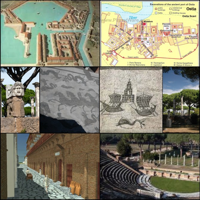
Ostia, Harbour city of ancient Rome. Being so close to the heart of the Roman Empire, in the third century BC Ostia was primarily a naval base Later “in 267 BC it became the quaestor Ostiensis (officials taking care of the fleet)” (ostia-antica.org). Over time after Rome’s military success Ostia gradually became a commercial harbour. Providing a landing for imports such as grain from Rome’s outlying colonies. Over time Ostia, no longer governed by Rome, developed its own government.
The city of Ostia is a great example of early urbanization. The city a spectacular theatre that held 3,000 spectators. The city did not seem to have any natural resource available to provide an adequate economy. Rather instead the city’s income was largely based on taxing imported goods. This is evident with the construction of the harbour basin. The harbour provided a safe haven for the vessels too large to sail up the Tiber River directly to Rome. The basin was constructed under Claudius in 42 AD. The basin was connected to the Tiber River with man-made channels. From 106-113 AD a second larger hexagonal basin was built behind the original. Providing a safe haven for an estimated 200 – 300 ships at a time. From this point forward in Roman history Ostia was the landing place for the grain fleet from Alexandria in Egypt. With the harbour finished and with such a large tax base the construction was focused on the city of Ostia itself. As seen in the photos the city was protected by a large wall. The map of the city also depicts the large Cardo Mximus and Decumanus Maximus (North-South and East-West road in a Roman city). The Roman straight roadways throughout its territory allowed Marble to be brought into Ostia and the constructions of temples are also evident. There are also grand mosaics that are still intact today. Over time other goods began to be imported to Rome through Ostia. During this time there was a rise in society of the middle class, traders and merchants alike. With such profit to be made merchants from all over the Western Mediterranean flocked to Ostia for the possibility of wealth. The city is said to have topped out at 50,000 inhabitants with sum 17,000 slaves. This started the need for more housing. Apartments were constructed up to three floors and were the habitations for the commercial middle class. There were also an abundance of Domus, houses for the upper class. With such a population, surely came hotels, brothels, bars, baths, workshops, and several public buildings. Although Ostia was much smaller than the harbours of Alexadria and Carthage. It was said to have been much more functional (ostia-antica.org). It is interesting to think of how large the hinterland must have been in order to provide the agricultural needs of Ostia. Especially being located so close to Rome, whose population is said to have exceeded one million at its height.
Ostia is now some three kilometers away from the Mediterranean Sea. Buried by years of sediment brought down the Tiber River. Ostia served a vital role in the success of Ancient Rome.
Nice work, good thoughtful commentary, well written and good additional research…nice
Reblogged this on notenoughtimeintheworld.
You reflagged bu didn’t leave the 500 word comment (either here or on your own blog)
still trying to figure out how blogging works….somehow the commentary didn’t post.
Reblogged this on dobbyslittlesock and commented:
Arya, Darius A. “The American Institute for Roman Culture.” The American Institute for Roman Culture. AIRC (Non-profit Institution), NEU (Educational Institution), May 2010. Web. 22 Jan. 2014.
Ostia Antica was once a very successful and vital city to the Roman Empire and the city of Rome itself.
Ostia began as a small port city at the mouth of the Tiber River. The Tiber river was import to the Romans because it gave them access to the Medditerainian Sea. With this access they could begin to trade things such as grain, olive oil, wine, and gold. However, the primary commodity that made Ostia Rome so interested in creating a port was salt.
Ostia Antica began not as a port city but as a military fortification, or castrum. Massive walls and warehouses form in order to store the shipment of goods heading to Rome. All the cargo on its way to Rome stopped in Ostia and was checked. Ostia Antica became a vital city to Rome and soon it began to look like Rome.
Because of Ostia’s great new importance and all these goods traveling through Ostia, it starts to become more and more wealthy. With this wealth the castrum becomes a city. Ostia is a city the grows so rapidly and has so much economic activity that it begins to resemble Rome itself. Buildings are no longer being built out of timber, but the timber is used to fire and build buildings out of brick. The walls are covered in marble and fresco. Roman city buildings begin to form; buildings like temples, market places, theaters, and governmet buildings. Some government buildings are even built entirely of marble as to display the wealth of the Roman empire. Beautiful, extravagant architecture is built. A wealth Roman city quickly grows. Ostia Antica looks like Rome did in its height.
Even after all its success, Ostia begins to decline when a new port is formed. Portus digs a canal that cuts directly to the Tiber River, and trade soon moves from Ostia to Portus. Goods now bypass Ostia completely. There is no longer any reason to stop. Out with the old, in with the new.
However, this is not the end of Ostia Antica’s life. The city itself loses much of its income however, the physical city itself remains and Ostia becomes a residential city. The brick buildings with marble and fresco are, for the most part, turned into residential buildings. Ostia becomes a resort city for the wealthy. Ironically most of the people that live in this new resort city are the people involved in trade over in Portus, traders, merchants, and government workers. Because of this new residential city, trade in Ostia drops even more.
With the rise in Christianity, Ostia, much like most of Rome, becomes disappear. Pagan structures are taken apart and used to build other things. Spolia begins to erase the once wealthy port city.
Ostia Antica however, is one of the more persevered Roman cities because of its dismantlement and abandonment. The city begins to bury itself in all its ruble and a new city is not built on top of it, allowing its preservation and rediscovery. Ostia gives insite to us on what Rome looked like in its height.
Very nice work – good commentary, good external research and thoughtful commentary…great, thanks
Reblogged this on esobrien and commented:
Ostia Antica was the harbor city for the city of Rome during the time of the great Roman Empire. Based on the layout of the city we can study it today and see that it very much followed the Roman city model. Like most cities under the rule of the Romans, this city experienced the fruits of being a part of urbanization in the classical world. Its prime location on the mouth of the Tiber River allowed the citizens to grow enough food supplies to escape the limitations of subsistence farming, which in turn led to surplus and all the benefits that follow that. They could branch out in job responsibilities, creating specialization that enabled the community to go from mainly working on the fields, to having free time. Thus, art and culture itself developed greatly, and we find sculptures and monuments throughout the city, as well as beautiful frescoes on the walls.
Based on the format the Greeks used while establishing their empire along the Mediterranean, Romans applied the same grid layout to their colonies and hinterlands outside of the main city of Rome. However, cities like Ostia Antica were much more complex grid systems than those of Greece. As opposed to simply having one plaza, one temple, and a single market area all in the central square of the town, Ostia Antica had developed enough to contain multiple plazas, market areas, and neighborhoods to accommodate the growing wealth of individuals and the city as a whole. Also, the increasing success of the city created more opportunities for individuals to work but still have time to take part in the thriving culture, so the population of Ostia Antica inevitably grew. To support the livelihood of more citizens living in the city, more temples, baths, and theaters were also built, developing the town into its own community, not simply a money-making region that Rome owned and used.
This development and accommodation to the desires of the people is so common today we often overlook it. We tend to think of the towns from ancient civilization as solely focusing on work and survival, as if they had nothing else to distract themselves with like we do in our much more complex society today. However, their construction of theaters and grand wall-art pieces, as well as their expansion from being a port town for Rome to being a lively city is very similar to growth seen in almost any city in existence today. We build more parks, remodel more entertainment centers, and plant new restaurants all to encourage more growth and more economic flow. Solely based on the city layout, the town’s expansion, and artwork found from that time period, it is easy to see the similarity of humanity overtime. Not to put a focus on the materialism that is so deeply engrained into our society today, but rather looking at classical peoples continuous search for more life giving activities and things, as opposed to living monotonous lives, day in and day out.
I really like your last paragraph, nice, thoughtful way to bring the piece up to date. Nice work…
Reblogged this on Neverending Wanderlust and commented:
These images give us a plethora of information about the ancient Roman city of Ostia. Starting with the map, the importance of roads to the city immediately stands out. The city does not appear very large, yet it has a seemingly well-developed road system. However, the roads are not laid out in the strict grid like pattern that the Romans favored in their later colonies, so this is likely one of the earlier cities the Romans established. As we discussed in class, the intersection of the Cardo Maximus and the Decumanus Maximus forms the center of the city. In Ostia, the forum was placed at this key intersection; baths, temples, and government offices were likely located here as well. Unlike the Greeks, the Romans built cities with multiple centers. In Ostia, there appears to be a second center to the east, where the theater is located. The map shows additional baths near the theater, and a secondary temple was probably nearby. The picture in the bottom left brings the images of the ruins of Ostia to life. It shows the high quality roads that the Romans were capable of building, which greatly facilitated trade and growth in individual cities and the Empire as a whole. The raised sidewalks show the thoughtful planning that went into building Roman roads; the roads needed to be used by everyone, so they should be done right. No one wants to walk around in the dirt and other unpleasant things that accumulate in the roads! The pottery jugs in the images were used for storage of many goods including olive oil, wine, and the eternal Roman favorite of fermented fish sauce.
Many of the images reveal the importance of the sea and sea trade to the city of Ostia. The harbor depicted in the first picture seems well protected from the open sea, which would have made it an ideal place for merchant vessels to stop and trade. The goods they brought from foreign lands could have easily been brought from Ostia to the rest of the empire, thanks to the Roman road system. The Decumanus Maximus leads directly from the port to the city center, then to the secondary center in the east, and out the walls to the rest of Rome. This reflects the advantage the Romans had over the Greeks in their empires, as the Greeks could not develop roads (and thus could not achieve reliable wheeled travel), so they were limited to coastal cities and a small hinterland. The middle pictures on the second row seem to show sea monsters. In one, someone in a chariot, probably Neptune, fights the monsters and protects the city. Most likely, a temple or other building in Ostia was dedicated to Neptune to ensure his continued protection of the city. The other picture shows two boats headed toward the safety of the port of Ostia, represented by a structure, possibly a lighthouse, and away from another nefarious sea creature. Clearly, the sea was of huge importance to Ostia.
Nice work Matthew…especially like your discussion of the importance of the sea…excellent
Reblogged this on nmjabs and commented:
This is a series of images of the Roman city of Ostia. The map in the upper right corner reveals a lot about the purpose and composition of the city. First I will outline a few of the major components that define Ostia’s composition and then I will discuss some of the possible explanations and implications of these components. The city is situated along the Tiber River. It has the two major roads found in most Roman cities, the Cardo and Decumanus. A wall outlines most of the fabric shown and is, generally, in the shape of a half circle with the center about a current bend in the river. The course of the ancient Tiber River was much straighter along the edge of the city then today’s Tiber which bends sharply near the center of the city. The map reveals many of the traditional buildings associated with Roman cities; the forum – centrally located near the intersection of the Cardo and Decumanus, a public piazza, a main gate (porta maxima), many bathhouses, a theater, and other “public buildings.” Many of these public buildings are grouped along the Cardo and Decumanus and, although not specified on the map, probably included a tax collecting office, governor’s mansion, and a temple or two.
The ancient Roman civilization thrived because they figured out how to make extremely high quality roads. The roads connected the cities of the empire and thus created a very successful system of cities that depended on reliable trade. The expansive roads, like other great works of Roman architecture, signified the empire’s power through its ability to manipulate and control the landscape. The Cardo and Decumanus are, like in other Roman satellite settlements, Ostia’s connection to other inland cities. (It is interesting in Ostia that the streets are not completely straight. My hypothesis is that before Ostia was a Roman port city, it was a Greek City and the Romans built their roads over some of existing infrastructure.) The location of the city along the Tiber River probably made Ostia very important to the Roman Empire (and more specifically the capital city of Rome). A few of the other images, the ships with the gridded sails and the 3-dimensional recreation illustrating Ostia’s well defined ports suggest that the movement of goods via boats was critical, and probably primary, to the city’s function. Rome was allowed to grow to a population of over one million because of the empire’s massive hinterland and reliable trade routes. Many of these goods probably came through Ostia’s ports. The town walls at Ostia also suggest to me that the city was built over a Greek establishment. Many Roman cities, especially so close to the heart of the empire were absent of walls because the Romans controlled so much territory there wasn’t often a need to defend from invaders, except of course at the most extreme edges (Hadrian’s wall in England comes to mind).The theater however, was a staple of Roman cities. Especially during the high Roman Empire, the elite relied on a food rations and games to control and please the masses. Similarly, the forum was fundamental to Roman cities. The forum was the location of most of the trade and commerce in the city (which explains its location near the intersection of the two major roads).
For me, the Roman forum is one of the basic lessons in understanding urban space. I believe it was Edmund Bacon, a 20th century architect and urban planner, who made the comparison between the Greek acropolis and Roman forum. They represent two ends of the public space spectrum; the acropolis is a temple atop a hill- a shining monument, and the forum is a space carved away from a mass – a room with sky as its ceiling.
Really nice work…great analysis of the morphology and function of the city…very, very nice…
Pingback: Blog Exercise One | Uncharted
Reblogged this on carlylb and commented:
Ostia Antica is an ancient port city located about 15 kilometers southwest of Rome. In 396 B.C., imperialist Rome took control over Ostia Antica as its first colony. Ostia Antica is the Roman city equivalent to the Greek city Miletus in that its ports have been subjected to rising sea levels and sedimentary deposits. The silting of the ports as well as warfare led to the decline and abandonment of both cities. The city of Miletus is located near the mouth of the Maeander River, whereas the city of Ostia Antica is located on the mouth of the Tiber River. Rome depended on Ostia Antica as its major seaport to trade with other cities. This seaport supplemented the trade system of Rome, which had been well developed due to their extensive network of roads that extended far inland. Their roads were stone-paved and allowed for wheeled traffic as well as pedestrian traffic. The gridded city pattern used in Roman cities, such as Ostia Antica, originated at Miletus. The gridded city pattern was made up of roads that ran east-west that were each known as a decumanus, and roads that ran north-south, which were each called a cardo. There were two main roads, the east-west main road was the Decumanus Maximus and the north-south main road was the Cardo Maxiumus. At the intersection of these two roads was the Roman forum of the city, which was the market place and the Roman equivalent to the Greek agora. The ruins of Ostia Anticas’s Roman forum, with its classical columns rising up from the grounds, are shown in the last picture on the second row listed for this blog. Like Miletus, Ostia Antica was home to a theater, which was used by the empire as a means to control the masses by distracting them in the form of entertainment. The amount of similarities between Miletus and Ostia are no surprise as ancient Greece and ancient Rome shared much in common. Though much of the ruins of Ostia Antica have been picked over by people of Middle Ages and Renaissance over the years, such as the Baroque architects who wanted to use the marble for building structures and sculptures in Rome, the site still shows the high cultural importance of art with many sculptures, mosaics, and general adornment to public buildings. The artistic picture of horses and sea creatures (the second picture on the second row) is actually a portion of the mosaic floors of a Roman bath in Ostia Antica. A Roman invention, the public bath was used by the majority of the city’s inhabitants on a daily basis, and like the theater, it was used as a means to prevent an uprising by keeping the citizens of Rome content. The baths, theaters, and roads were all evidence to Rome’s identity as the most advanced technological civilization up to its time. Ostia was not only used as a trade port for Rome, but also as a Roman naval base, which lead to one ship building being one of the city’s specializations.
Very good – love the comparison with Miletus…nice work
Reblogged this on worldsite2014.
No 500 word blog post – you can write it as a comment here or a comment on your own blog, but at least 500 words must accompany the reblog…
Reblogged this on Chris Robertson Urban Geography Blog and commented:
The first thing I notice are the pillars that are in several of the pictures. The Romans used these colonnades as a kind of architectural “fingerprint.” Most of their major colonies had these colonnades and the Romans used them to represent “order, structure, and power.” The bottom left picture also shows a street in a city. Roads were another signature of the Roman expansion. The Greeks were unable to develop roads due to the rocky and mountainous nature of their country side. The Romans, however, dwelt on relatively flat land, allowing the construction of roads. These roads allowed them to expand inland, which gave them access to much larger hinterlands that provided resources for Rome and other larger colonies. The bottom right picture shows an early amphitheater. These amphitheaters were one of the ways the Roman government kept the people happy. They would put on circuses and other performances to entertain the population. Another way they did this, at least in Rome, was to provide monthly rations of bread and oils, among others. In the map of Ostia, you can see the gridded nature of the city (although there are parts that are diagonal in respect to the rest of the city). This model for the construction of cities and colonies was first developed by the Greeks. When the Roman Empire began to colonize and expand, they used the Greek model for their own cities. This particular model allowed easy travel within the cities. In the map of Ostia, you can also see the centralized location of the majority of the baths and the forum. In gridded cities the most important buildings, like temples, markets, baths, and palaces, were centralized in order to provide the easiest access to the most people. Ostia was the major seaport for Rome (some think it may have been the first Roman colony), which lay further inland. This port received the majority of resources from Rome’s massive Hinterland, receiving resources from places like France all the way to Egypt. In the early first century AD, they built a harbor that would receive the majority of trade. Due to heavy sedimentation, the first harbor became filled with sediment and a new one had to be built. The new harbor (seen in the top left picture) was built in a hexagonal form that reduced the erosional forces of the river and the sea. Ostia likely reached it’s height in population in the 2nd and 3rd centuries, having around 75,000 inhabitants and became more of an early tourist destination instead of a trading port. Due to it’s heavy sedimentation and the fall of the Roman Empire it’s population and influence dwindled in the 4th century. In present day, it lies about 2 miles inland, the result of sedimentation along the mouth of the Tiber river. It is now mostly known for it’s archaeological importance. It has been remarkably well-preserved throughout the past 2,000 years and it serves has a pretty good model to what Roman cities were like 2,000 years ago.
Nice work, well thought out and a nice analysis of the problems of the harbor…well done
Reblogged this on jwpruss and commented:
These photos focus on the predecessors of modern civilization and modern cities and metropolises. These cultures laid the groundwork for the modern world, as we know it. These peoples developed from very primitive communities of hunter-gatherers. Then the discovery of useful natural resources led to them settling down. As they settled down they would trade these resources with hunter/gathers to get their sustenance. They developed farming and learned animal husbandry. As farming techniques developed, less people were required to farm which allowed people within the communities to start working in develop other services for the community. The innovation of the granary required grain to be stored. Stored grain needed protection so standing armies would have to be raised. And to support an army you need a blacksmith. To support the army you need to collect taxes. Tax collection develops a bureaucracy, which in turn leads to the development of a writing system and literacy. To be able to pay taxes you need currency. When these groups of people settled down from their nomadic ways, they started a domino effect of development and threw themselves and their cultures into the future through mechanical, social, and intellectual development.
The Greeks were the first real colonists to go into the Mediterranean region and they established cities all based on the same layout and governance systems. They introduced the world to the grid street system. Greek cities were laid out in grid patterns and the most important buildings to the city were located near the city center to allow easy access to all the city residents.
The Romans adopted the Greek system and expanded their colonial power. Their success stemmed in the invention of the wheel and their perfection of road technology. The Greeks were limited to staying on the coast while the Romans could move inland and create a system of transport and trade with roads. The Roman cities were much larger than the Greek cities. So they had not only city centers but also neighborhood centers. These neighborhood centers featured baths and markets. The Roman cities were all about Order, Structure, and Power. We saw the first suburbs thanks to the road system. The main people who moved to the suburbs were the rich who were tired of the new urban problems of over crowding, noise, smell, and disease. The over crowding was in part do to the new method of building which including multistory apartment buildings in which they were able to cram more people into the city.
These cities were the major influence in the advancement of the organizing of the human race into cities and in the innovations that our modern society relies on for simply surviving today. We owe our way of life to these peoples who lived thousands of years ago and to their ingenuity.
Commentary is well written although doesn’t really address the images very specifically. You are also about 10% short of the word limit. I’ll let it go this time, but in future you need to make at least the 500 words…
Reblogged this on maybeokay and commented:
Ostia Antica is an ancient city 20 miles southwest of Rome located on the Tiber River. Though it now lies nearly three miles inland from the Mediterranean Sea, it was a coastal city prior to sedimentation clogging up the Tiber delta and causing the coast to slowly migrate further seaward. Ostia is important as a Roman harbor city, but this incarnation was probably predated by smaller Bronze and Iron Age villages in the location, likely based on panning nearby salt deposits (“Ostia Introduction”). Regardless, it fell under Roman rule—allegedly around 600 BC, with archeological certainty by about 400 BC. Its earliest Roman purpose was as a naval base, but this focus shifted as Roman rule extended over an increasingly large (and insulating) area.
By 150 BC, Ostia had transformed into a commercial center—and entrepöt where sea-based goods were sorted and sent on to Rome and other Roman cities, as evidenced by both the Roman and nautical influences in its remaining artistic inlays today. Shops, temples, workshops, and bathhouses had been built and, following several occupations and sackings, so were town walls to protect the city from outsiders. Over the subsequent 300 years, the city thrived, grew, and was built on to; leaders fought the harbor’s sedimentation, building new harbors, and new entertainment (including the theatre able to fit 3,000+ people) for the growing population. Limited in space by the riverand ocean, growth and time were answered by going up, and “Over the centuries, Ostia’s ground-level rose, and the road was elevated”—making descent in the city a step back in time (Steves). At its peak, the inhabitants of Ostia numbered around 75,000, just shy of 2,000 less than present-day Fayetteville. By 400 AD, however, the city began its decline, with decreasing importance and conditions till its abandonment around 900 AD.
During its several hundred year span as a major Roman harbor city, Ostia typified the classical city fairly well. It had distinguishable neighborhood centers with associated bath, bar, and apartment/domus complexes. It possessed the cardo maximus and decumanus maximus of traditional Roman cities, with important public buildings centralized along these corridors—the large theatre (bottom right picture), the “square of corporations” and “square of the heroic statue,” the forum and curia, along with a wide array of shops and workshops (“Ostia Introduction”). Most of these were arranged along the decumanus maximus, contrary to typical cardo-centered Roman cities. This seems the result of the presence of the ocean and Tiber River; as a whole, the city seems elongated to maximize waterfront space. This water orientation is reflected in the application Roman grid system, which is much more stringently
employed in neighborhoods away from the coast (particularly the area surrounding the forum), compared to more
perfect applications such as Timgad.
Altogether, this molding of gridded city plans to major transportation ways (in terms of people, goods, or
currency) has a remarkable resemblance to cities today, centuries and even continents away. Southern California
(namely Orange County), for instance, requires only a reduction in scale, 1200 years of dilapidation, and replacement
of the Tiber River with the 5 and 405 freeways to pass for Ostia’s upstream sibling (see comparison below of coastal
Ostia and Santa Ana, CA).
Sources:
“Ostia Introduction.” Ostia-Antica.Org. N.p., 1 Apr 2013. Web. 26 Jan 2014. .
Steves, Rick. “Ostia Antica, Near Rome.” Rick Steves’ Europe. N.p., n.d. Web. 26 Jan 2014. .
“Topographical Dictionary – region 1.” Ostia-Antica.Org. 2013. http://www.ostia-antica.org/dict/1-plan.htm
Santa Ana, CA. 2014. Map. GoogleWeb. 26 Jan 2014. .
Very nice, I love your modern comparison with Santa Ana – well written and well thought out…well done…
Reblogged this on sbw09 and commented:
Ostia was a harbor city of ancient Rome, serving the capital city of the Empire 30 kilometers to the east. It was established at the mouth of the Tiber River, but silting/sedimentation of the river from the Middle Ages to the 19th century moved the shore out three kilometers past the city (ostia-antica.org). Ostia had a few natural resources, including salt, which was extracted by pans (ostia-antica.org). However there were not enough natural resources to sustain the economy, so many of the city’s goods (including grain, oil, lead, wine, marble, etc.) had to be imported through trade (ostia-antica.org). Parts of the city had the Roman standard system of streets and roads, including the Cardo Maximus (North-South road) and Decumanus Maximus (East-West route). According to ostia-antica.org, only the northeast quarter of the city had the rectangular, gridded plan; the rest of the development was irregular. As commonly seen throughout the former Empire there was a theater that could seat three thousand people, built by Marcus Agrippa, the right-hand man of Augustus (ostia-antica.org). As seen in the bottom-left image, the use of arches, a technology that permitted the building of larger structures, was prominent. There were a variety of other architectural styles in Ostia (ostia-antica.org). Also according to the source walls were built around the settlement in 63 BC by M. Tullius Cicero. There was no bridge over the Tiber; people crossed the river by ferry. In 42 AD under the direction of Claudius a large artificial harbor was built to the north of Ostia to protect larger ships that couldn’t make the trip upstream to Rome; another basin, hexagonal in shape, was constructed beside the first from 106-113 AD (ostia-antica.org). Ostia in its heyday had a growing, diverse population of about fifty thousand, including seventeen thousand slaves mostly from Egypt, Turkey and the Middle East (ostia-antica.org). To accommodate the population increase, apartment complexes were built two or three stories tall, the medianum residences for the commercial middle class, and the Domus for upper class persons (ostia-antica.org). Shops, hotels, and bars, a necessity for the voyage from Ostia to Rome or other ports, also came up according to the website. The source also states that Ostia was originally a naval base in the third century BC, serving as the seat of one of the quaestores classici (officials taking care of the fleet). The office that the city held had a part in the Punic Wars against Carthage. By the next century Ostia had slowly but steadily become a civilian commercial harbor.
Many have the image of Ostia as just a suburb of Rome, knowing that only thirty kilometers separated the two cities, but Christer Bruun begs to differ, believing that the harbor city had an identity all of its own. He states that while Pompeii, another Roman port, draws more tourists than does Ostia, Pompeii’s history “was cut short when Rome’s imperial period was only in its infancy, Ostia…still thrived during the third century C.E., and we have historical sources that allow us to follow its development well into the 400s” (ias.edu). Thus Bruun believes that Ostia was a more important settlement than Pompeii and other Roman harbors.
Good work – lovely use of a little historical research to fill out the discussion of the city form. Very nice….
Thanks!
Reblogged this on crainer2014 and commented:
Ostia was one of the first Roman colonies established during the early days of Rome that provided port access to the city of Rome itself at the mouth of the Tiber and opened the Tyrrhenian Sea and the greater Mediterranean beyond to eventual Roman expansion. Ostia would come to serve as the principal port destination of the massive amount of resources needed to sustain the Imperial city of Rome, fed by the abundance produced from all corners of the Roman world. Given the significance of Ostia’s role in facilitating the flow of resources into the center of the Roman world, it is interesting to examine archeological evidence and visual reconstructions of this once great Roman port city.
The Roman motto “Order, Structure, Power” implies a sense of organization and rigidity that personified the Roman psyche and can be seen in the building designs of Roman cities such as Ostia. With the symmetrical design even in the construction of an extensive harbor, as seen in the visual reconstruction, a design built to purpose with a certain pragmatism can be seen, while maintaining the grandiose Roman style of an Imperial power whose might and culture were supreme, at least in the eyes of Rome. The design of Ostia, as displayed through the excavations, was based on two main roads, a main east to west road and an intersecting north to south road, that provided reliable access to gridded neighborhoods and civic buildings and maintained a reliable trade system through a connected road system that provided safe travel to Rome and further into the Roman hinterland. Ostia typified a Roman city, in that it used a gridded building system, adopted from the Greeks and expanded, as the Romans often did, and provided the necessities that the Romans became accustomed to, such as an amphitheatre for entertainment and temples for religious needs. Ostia also seems to have had a defensive wall encompassing the city not facing the river Tiber, possibly built to protect Ostia in its earlier history, as once the Roman Republic increasingly committed to preemptive “defensive” invasions and established itself as the sole Mediterranean superpower, the need for a wall in a city so close in proximity to Rome would seem non-essential. The visual reconstruction also presents an orderly, free-flowing city that was clean and visually appealing, which was a fairly momentous accomplishment seeing as how the standards of living decreased significantly once the guiding light that was Rome faded into history, prevailing to a millennia of comparably darker, less sophisticated standards of living, at least in the splintered remnants of the Western Roman Empire. Overall, the city of Ostia represents what the Romans ultimately sought to accomplish through their expansive history as historical trend setters and as the premier city planners of the ancient world. The city of Ostia represented the Roman ideals of “Order, Structure, Power” through the thoughtful planning that provided a functional, prosperous city that probably epitomized the glory that was Rome, or at least was an example of the grand possibilities of the ancient Roman world.
Excellent – clearly written, well thought out and nicely informative discussion of the morphology of the city and its origins.
Reblogged this on garretthenrythoughts.
Due to what we learned about the formation of major city systems, the first two images jump out at me instantly. The first demonstrates an engineered use of a major river system. The creation of a sheltered port and what looks to be a residential waterway indicates a sign of major trade growth as well as slightly more advanced technology and currency.
This is what drew my attention to the second picture, Ostia (latin for mouth) a municipio or district of Ancient Rome. Acting as a major port and harbor, I instantly I see an early use of opportunistic specialization. Access to the Tiber River, the creation of the hexagonal port from the first image, as well as a market place, established major roadways and several public baths indicates an organized governing body.
As I looked at the last pictures, (which I can’t seem to get any bigger) I thought about what an established government system, with a budding economy, does for fun? And then my mind started to wander. I started thinking of that UFC fight recently, the one where Anderson Silva broke his leg against Chris Weidman. http://www.liveleak.com/view?i=b55_1388295540
Dare you to watch it.
And I was wondering, why continue to watch this? The clip above has 174,715 views. And then I realized, because people love blood. That reminded me of the bread and circus of Imperial Rome. How do you satisfy a population of merchants, people who can AFFORD to live in the city? Ostia eventually grows to 75,000 inhabitants in the 2nd and 3rd centuries. Evidence of a museum, a theatre and all the bath houses, indicate a major cultural investment in the city. Not just the local government, but private donations by newly rich citizenry. As evidenced by the rendering in the lowest left, there must have been a great focus on both public and private architecture. The emergence of the early Tuscan column (a simple variation on the Greek Doric order column) as well as the Roman Basilica and Forum indicates large amounts of government spending. The inspiration of a civic pride was a useful tool for helping not only maintain control over the masses, but as an attempt to create a historical record of Rome’s societal supremacy.
The two center images, what appear to be depictions of some sort of story or legend indicate a system of cultural education. A societies’ ability to communicate its rules and customs is fundamental in the growth of that society. Similar to the civic architecture, the use of stories passed from generation to generation help establish a strong foundation of pride and innovation. A growing artistic community in a city like Ostia would have almost limitless room to work. Due to the expense of paper in Ancient Rome, artists used newly built basilicas to communicate their work. The emergence of popular individual artists, combined with a government willing to spend great sums of capital on the civic image, would make for quick and radical cultural progression.
All of these images represent one simple fact. The access to a major resource (wood, salt, trade routes etc. etc.) allows for accelerated growth across the societal board; technology, art, architecture, trade. Rome was able to take advantage due to their vast influence and access to a great variety of resources.
Good work – I especially love your little insert about the love of blood sports 🙂
Pingback: Blog Exercise One | parymayne
Reblogged this on The Urban World and commented:
Ostia Antica, perhaps ancient Rome’s first colony, provides excellent insight into the basic morphology of the classical Roman city structure. Owing to the irregular course of the Tiber, the streets likewise follow an irregular gridded pattern, yet logical pragmatism still ruled the city’s layout. While the life of the city centered around the wharf, the imaginations of the citizens likely centered around the forum, the murals, the sculptures, and the ornate architecture. This provided sustenance to the souls of Ostia’s citizens, even as the wharf provided trade, and a steady supply of support from Rome to sustain the city’s economy and whatever dearth of goods the citizens could not provide for themselves.
The heavy nautical themes are easily identifiable in the murals, particularly the mural depicting Neptune’s chariot drawn by four horses, or hippocamps, flanked on all sides by sea serpents engaged as mounts, as human slaying beasts, and as simple guards or spectators to the happenings occurring all about them. The mural depicting the pair of ships, the tower, and the dolphin, a favored animal of Neptune, seems to indicate a fervent desire that the blessings of Neptune would fall upon those traveling to and from the city. As a nautical city, homage to a sea god would be of preeminent importance in assuaging the anxieties of anyone with an interest in trade and travel, which would directly be a large portion of the city’s populace, and, indirectly, be the city’s population in total. Carved statuary of Neptune would only serve to reinforce the omnipresent apprehensions made manifest in the religious devotions of the average citizen.
Of course, layered amongst the devotion to Neptune would of course be the civil engineering that was the hallmark of Roman civilization. The stone paved roads were likely cambered to provide drainage, while also being smooth enough for citizens pulling hand carts to easily navigate. Apartment buildings, baths, the forum, the lighthouse at the entrance to the harbor, a temple to Neptune, and of course government buildings of varying stripes were, by the conforming architectural designs, likely all built to specification at the behest of the Roman official directing the construction of the colony. At the same time, within the walls shown in the city map, we see wide open spaces available to pasture livestock and light agricultural endeavors. Of course, those same walls seem somewhat laughable as a defense given that their most likely avenue of invasion would be aquatic and not terrestrial.
Yet the city’s heart and center would have been the forum, around which the city would lay, cradling the forum as a mother cradles an infant. It is in the forum where all manner of large gatherings would occur, from large religious ceremonies, to performance arts, and even, most importantly, government functions. Little wonder that this would be nestled away, equidistant from both the walls and the harbor in the event of an invasion, the defensive headquarters and final redoubt would indeed be the forum, a simple and safe fallback easily remembered by all.
Really nice discussion of both the symbology and the morphology…well written and well organized little piece – very nice…
Reblogged this on jennnyp123 and commented:
Ostia was a harbor city of the Ancient Roman Empire. Located just west of the heart of the empire, the city acted as a main port and trading center. The construction of Ostia reflects the typical design of ancient cities while incorporating its own unique elements. The city had few of its own natural resources and as a result relied on trade to support its citizens and the empire. Ostia is located at the mouth of the Tiber river allowing easy transportation of goods to the city of Rome and other parts of the empire. Roads have been found running South- East starting at the Tiber to further facilitate trade (ostia-antica.org). Large harbor basins, like the hexagonal one in the picture, were built to house those ships that could not travel down the Tiber to Rome. With the capacity to house hundreds of ships at a time, the city was able to flourish taxing imported goods such as grain. Ostia was not simply a harbor but a complete city with a developed culture. For example, the city had a local government and developed a series of important guilds or craftsmen and merchant associations. In keeping with the popular culture of the time the city also had a large theater built by Marcus Agrippa equpied to hold three thousand people. A great deal of artwork, such as paintings and mosaics, have been found in the area and are representative of the city’s purpose and values. For example, one of the images given to us depicts two large ships perhaps because at one point the city acted primarily and a naval base. We learned in class that contrary to popular belief urbanism is not a product of the agricultural revolution which can be seen in the major success of cities such as Ostia. Although increased agricultural yield is what allowed cities like Ostia to flourish, just like that of lots of other major cities,its success hinged on it proximity or access to a natural resource. Through innovation, agriculture was made possible in the hinterland of many major cities and through advances in technology goods could be transported all over the empire. Cities were developed based on function and specialization began to develop along with increased trade. Empires were first created as a result of cities taking other city’s surplus land. The greek empire was a first of its kind as it obtained a great deal of land but only in costal areas and without the technology to move inward they were confined to the use of sea transportation. The greeks were the first to develop an ideal urban model which can be seen all over the mediterranean. The Romans expanded on the Greek urban plan with the invention of things such as the road which opened up the hinterlands and allowed reliable trade. They expanded on the model of the gridded city which can be seen in the pictures given to us as a portion of the city follows this pattern with some additional elements. The city includes other aspects of traditional ancient cities such as the roman street system including a cardo maximus and decumanus maximus and the use of columns to convey order, structure, and power. The population of Rome eventually reached one million through its ability to draw on resources from the entire empire including the city of Ostia which managed to maintained its own unique identity at the same time.
Good work – nice discussion of the functions of a city like Ostia…
Reblogged this on ztamijani's Blog and commented:
The collage features information and art regarding the ancient Roman sea port-city of Ostia. Ostia followed typical Roman design features of the era with a baroque theme. Such baroque cues illustrated would include: the theater, stone columns lining major roads, grandiose stone sculptures, and murals that display wealth and power in honor of the city’s purpose within the empire while encouraging control over the population.
Nice introductory comments, but you need to at least attempt to make the 500 word limit…
Reblogged this on urban geographical issues and commented:
Ostia was a Roman City on the west coast of the Italian Peninsula along the river Tiber that greatly borrowed urban design from the Greek grid layout, but it expanded the nature of a city to a different level by the expansion of the road systems. Originally the city was founded a long salt flats and was an early producer of meats (Smithsonian.com).
Ostia wasn’t only a port city but due to its roads became a important supplier of goods to the Roman interior. The city was able to trade with other Roman maritime cities and the same time fill the demands of trade goods for the interior of the growing empire. The growth of imperial Rome heavily depended on grain trade and other commodities. The city consisted of horreas (warehouses) which were government regulate units for the storage of trade goods. In the late Republican era, Rome started the transition from becoming a grain producer to becoming an importer. This was primarily due because of the diminishing rural populations, population growth in Rome resulted in unsuitable population dynamics. It took nineteen farmers to feed one person living in a city. Overland transportation was still expensive and port cities in proximity to the Roman capital became important sources to feed the growing empire. Ostia grew in prominence to meet the demand with good roads and access to the Mediterranean. Ostia was composed of many insulae (multiple-dwelling units). Ostia had many Roman baths, public buildings, hotels, temples and open space such as homes with gardens and a large plaza (Vitelli, 1980).
Ostia started to decline in around 200-300AD with the collapsing economy and political struggles taking place within the empire. By the fifth century the importance of Ostia had diminished with the attack of the Barbarian tribes from the north. Then by the Middle Ages Ostia fell to Islamic forces of the Saracens. Furthering the decline the city also became infected with malaria and growth of marshes and lakes (http://www.ostia-antica.org/).
Nowadays, Ostia is no longer a port city. Its remains are now miles in land.
1. Source: Grain storage and urban growth in imperial Ostia: A quantitative study Giovanna Vitelli World Archaeology
Vol. 12, Iss. 1, 1980