This is a series of mental maps – use the images as a way to talk about behavioral geography and its impact on the discipline.
This is a series of mental maps – use the images as a way to talk about behavioral geography and its impact on the discipline.

#4 Behavioral Geography
Cognitive maps are one technique used in the study of behavioral geography, or the study of how humans perceive and behave in space. Behavioral geography developed out of human geography as a response to the “rational people” assumed in the quantitative models used to describe human activity (Bunting and Guelke 1979, 448-462). Behavioral geographers believed, for example, that spatial interaction models would be more accurate accounting for perceived geographic distances and not actual distances. Their hope was that “the use of empirical models of actual human preferences and perceptions would lead to the development of general theories in geography which were both deductively sound and empirically valid” (Bunting and Guelke 1979, 448-462). Even though that was the hope, there have been several criticisms about the difficulty of quantifying spatial cognition.
Since the 1960s, researchers across disciplines have worked to develop the theoretical framework and quantitative methodologies of acquiring information about what humans think about a space and how humans behave in a space (Kitchin and Freundschuh 2000, 1-8). The images above are examples of cognitive maps much like the sketch techniques used in the research of Kevin Lynch (1960), an early adopter of using drawing to reveal spatial cognition. Lynch, an urban planner, would have the residents of a city draw through different techniques to describe their knowledge of that city. Lynch’s work was an attempt to analyze cognitive images empirically by identifying how people make spatial relationships through primary experience and secondary media (Kitchin 2000, 9-23).
After Lynch published his work in The Image of the City, 1960, the use of cognitive mapping and spatial behavioral research exploded across several disciplines. Those disciplines included but were not limited to: psychology, geography, planning, architecture, anthropology, computer science, information science, and neuroscience (Kitchin 2000, 9-23). As a theoretical precedent, cross disciplinary research analyzing the many forms of secondary media to communicate space and spatial relationships throughout history also occurred, looking at images like, “cave paintings, three-dimensional models, maps constructed of various natural materials (sticks, shells, rocks sand) and man-made materials (paper, mylar, ink), satellite images, computer-generated worlds, and virtual environments”(Kitchin and Freundschuh 2000, 1-8). Theoretical and empirical research in this area can be applied to answering questions like ‘how are new routes learned?’, ‘how are routes between two locations remembered?’, ‘how are distance and direction estimates made?’, ‘how are relative locations between places learned?’, ‘how are maps interpreted and used for location and navigation tasks?’, and ‘how is spatial knowledge related to spatial behavior?’ (Kitchin and Freundschuh 2000, 1-8).
By working through the missteps and criticisms of the early theoretical and methodological approaches of behavioral geography and other related disciplines, researchers have been able to give insights and practical understanding to a number of applications. Conceptually, behavioral research has given understanding to urban planning, answering questions about how people engage the built environment. It has also given new understanding in education by informing how environments can be designed for better learning. Technically, behavioral research has informed spatial communication in geographic information systems, navigation systems, and the user interfaces of such systems (Kitchin and Freundschuh 2000, 1-8). Research built upon the tenants of behavioral geography will continue to be an important aspect of informing the design of the built or virtual environments with which we now interact.
References
Bunting, Trudi E. and Leonard Guelke. 1979. “Behavioral and Perception Geography: A Critical Appraisal.” Annals of the Association of American Geographers 69 (3): 448-462. http://www.jstor.org/stable/2562975.
Kitchin, Rob. 2000. “Collecting and Analysing Cognitive Mapping Data.” In Cognitive Mapping: Past, Present and Future, edited by Rob Kitchin and Scott Freundschuh, 9-23. London: Routledge.
Kitchin, Rob and Scott Freundschuh. 2000. “Cognitive Mapping.” In Cognitive Mapping: Past, Present and Future, edited by Rob Kitchin and Scott Freundschuh, 1-8. London: Routledge.
Excellent
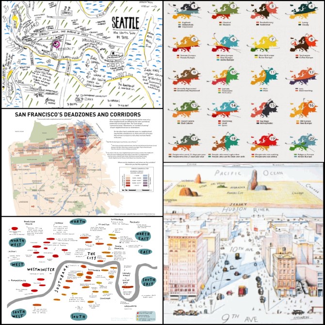
Like structural and humanist geographers, behavioral geographers are responding to the post-war/mid-century spatial analysts and their claims of objectivity within human geography. Structural, humanist and behavioral geographers approach the discipline from different perspectives, but agree that a multitude of factors influence spatial decision-making, not just economic ones. Behavioral geographers specialize in the individual level of spatial analysis rather than prioritizing aggregated data. The maps here range in physical accuracy in terms of scale and direction as well as in subject matter. Their makers are also a diverse group. They share that they have, on some level, made mapping personal.
“San Francisco’s Dead Zones and Corridors” is part of the results of a Berkeley project in 2011 and is the most physically accurate map of the group. It includes residential density (via a choropleth) and commercial zones, as well as highlighted streets of commercial activity. The two creators verified commercial activity with sources such as Google Maps and Yelp because what is zoned commercial is not necessarily a commercial destination for people. Cheng and Annechino (the creators of the project) also conducted 22 interviews with residents of the city and quotes from those interviews are included with the map. The content of those interviews defines the project as much as the map dominates the poster. In contrast the cover of The New Yorker from March 1976 (by Saul Steinberg) is probably best described as art, though it clearly presents a certain spatial perspective looking west across 9th Avenue.
Speaking of art, the mental map of Seattle, WA, by Skye McNeill, is displayed as part of a 2011 thesis turned book by Chris McCambell titled Personal Landmarking, (with which I think he earned his GDMFA at Maryland Institute College of Art). The project included asking 11 persons to map routes for the same beginning and end points in Washington DC, to which each person gave a unique path. Nowhere did I see mention of the phrase behavioral geography as I perused McCampbell’s project… which speaks to the sometimes unseen intersection of visual arts, particularly design, and geography.
Approaching the intersection from a sociopolitical direction is Yanko Tsvetkov. His Tearing Europe Apart: 20 ways to slice a continent consists of twenty identical outlines of Europe with “cut here” dashed lines (including the tiny scissor guides) which are intended to represent approximate locations for where Tea Europe and Coffee Europe, for example, can be delineated from each other. The twenty maps range from cuisine (good vs. bad, tomato vs. potato) to overarching cultural views (traditional vs. revolutionary) to what appear to be socioeconomic stereotypes (people who work 21 days per year vs. people who live 21 days per year).
The London mental map (by Mercedes Leon?) is not pointedly political, nor is it particularly artistic or scientific, but it more than loosely spatial and the human scene is set with racial, hierarchical, and cultural commentary. The simplicity of the descriptions – for example just “Rolls Royce” for one riverside area – reflects an expectation that viewers share the culture of the maker, if not the same zip code. The terms used in the commentary also mimic the demographic categories used in aggregate data collection. As long as people perceive space there will be artistic and scientific approaches to representing and documenting it, and many approaches that are blend of both.
http://www.newyorker.com/magazine/2012/12/03/life-lines-2
http://thesis2011.micadesign.org/mccampbell/
http://www.atlasofprejudice.com
http://groups.ischool.berkeley.edu/mentalmaps/
http://www.oxfordbibliographies.com
Very nicely done, great external research
Behavioral Geography focuses on the cognitive processes of individuals as they perceive, interact and respond to the environment around them. These processes are environmental perception and cognition, way finding, the development and use of cognitive maps, place attachment , attitudes developed about a particular space and place, and decisions and behaviors based on knowledge of the environment.
The images on display represent cognitive maps, which are also know as mental maps or mental models. They are mental cartographic representations that allow percipients to understand, assimilate and, when necessary, retrieve the information of their everyday surroundings in a quick and efficient manner. The also allow the individual to communication information to others that are not familiar with specify space in time. The concept of Cognitive maps was introduced in 1948 by Edward Tolman, a psychologist interested in understanding how humans depicted their environments and how they acquired the necessary information to maneuver their every day lives.
In 1948, psychologist, Tolman, began studying what became to be known as cognitive maps. He did experiments using rats and mazes. The rats were allowed to roam the maze, but weren’t rewarded. Later on, the rats could go through the mazes even faster when there was a food reward (because the rats developed cognitive maps allowing them to be familiar with the maze and know their way around.)
By no means are cognitive maps an exact physical or topographical representation of a pre-determined area. Wishing the brain they are not scaled to represent accuracies. They are just personal individual informative memories that have been store in the a specific part of the brain, sometimes unknowingly, from everyday interaction with a person’s surroundings and environment.
Humans and animals create this mental maps to remember places and to communicate information to others, whether in verbal form or visual cues.
In the Field of Behavioral Geography these maps are used to understand how individuals perceive their environment and what are considered the priorities within said parameters. Details are omitted as they fall in a lower lever in the relevant scale. Only things necessary for the specific task ahead are portrayed by the person who creating a cognitive map. Details will only apply to fulfill or complete a pre-established mental command.
“ Geographers researched the nature of “mental maps” via revealed place preference, subjective distance and configurational (layout) representation using non-metric multidimensional scaling (MDS) and layout matching (spatial congruence) techniques.
The methods used to assess spatial knowledge and examine how it is created have multiplied as researchers from anthropology, psychology, disability studies, artificial intelligence, computer science, and geography have explored assessment methods including pointing (for direction and orientation), interpoint distance examination (for spatial structure and layout and geometry), landmark learning, location/place hierarchies based on anchor point concepts, path integration (short-cutting and spatial updating), piloting (landmark navigation), chunking (route learning), “look-back strategies” (place fixing), verbalizing acquired knowledge (spatial linguistics) and other methods that use repeated behaviors to reveal and assess the spatial information contained in long-term memory (i.e. in cognitive maps).” (1)
Reference
http://richarddagan.com/cogmap.php
Very nice discussion.
According to Golledge, who ought to know, the origins of behavioral geography lie in the quantitative revolution. Like many other forms of geographic study that developed at the same time as spatial science and veered away, behavioral geography found fault with premises and limitations of purely quantitative geographic inquiry. The general assumptions at the basis of spatial science models were often simplistic—rational man driven by uniform knowledge to travel logical, economically-motivated tracks across uniform, featureless landscapes—and poorly explained the existence of outliers not conforming to the trend. Models were informative, useful, but to a bounded extent and often only within the realm of generalization.
As with other breakaway philosophies, behavioral geography was not opposed to quantitative methods, but instead emerged via the formulation of a series of related questions inadequately answered (or perhaps unexplored) by spatial science. What happens if the landscape isn’t featureless? What if man isn’t purely rational and equally knowledgeable? What if it isn’t a man but a woman or a child, and what if they are in the Midwest rather than the West Coast, or if they are poor? How might the model and its outcomes change if the subjects involved were more accurately portrayed? What can be gleaned by examining behavior? If spatial science was concerned with most, behavioral geography’s concern was each.
While spatial science drew inspiration from economics and statistics, developing behavioral geography called upon “new theories from psychology, marketing, sociology, and anthropology” (Golledge, 2008, p. 243). Areas of inquiry widely varied and “included spatial orientation and disorientation, geographic education, map design, human aspects of urban planning and landscape design, and models of spatial behavior and interaction” (Montello, 2013). These were explored by qualitative as well as quantitative methods—interviews and models, surveys and statistics.
Mental maps, such as those pictured above, are one outcome of behavioral geography. Some of these are the interpretation of place by a single individual, as can been seen in the maps of Seattle and London in the top and bottom left images, respectively, which show the subjective cities of the artists—what things are there, where they are, and what they mean. Other mental maps reflect a more cumulative mentality, humorously in the case of the right images. The top shows various perceptual divisions of Europe—by weather, money, laziness, choice alcoholic beverage, and ability to fix one’s own sink among others—while the bottom derisively shows Manhattanites’ clipped view of the world. Finally, other investigations are more quantitative, such as the San Francisco dead zones and corridors map aimed at comparing the actual residential/commercial contents of San Francisco with residents’ perceptions.
The impact of behavioral geography, however, goes beyond perception checks, art therapy, and satire. It helped challenge and refine spatial science models and added qualitative tools and methods to the geographer’s arsenal. It also “facilitated a greater engagement with philosophical and epistemological issues, forged productive interactions and relationships with cognate disciplines, and helped lay the… groundwork for human geographers to engage with contemporary social, environmental, and political issues” (Argent, 2017).
Argent, Neil. (2017, March 6). Behavioral Geography. The International Encyclopedia of Geography. http://onlinelibrary.wiley.com/doi/10.1002/9781118786352.wbieg0875/abstract
Golledge, R. G. (2008). Behavioral Geography and the Theoretical/ Quantitative Revolution. Geographical Analysis, 40, 239-257. Retrieved from http://homepages.neiu.edu/~dgrammen/2008GOLLEDGE.pdf
Montello, D. R. (2013). Behavioral geography. In B. Warf (Ed.), Oxford bibliographies in geography. New York: Oxford University Press, Added 2-26-2013. http://www.oxfordbibliographies.com/
Great external sources.
Behavioral Geography is a results as Radical Geography, Structuralism, and Humanism of the fracturing of the discipline into multiple perspectives in the 1970s.
Pickles J., Geography and Humanism (Blackboard Reading).
By 1970, there were several authors who had indicated to the requirement for a ‘’more human geography’’. Human geography is the place where decision-making and human behavior were combined into spatial patterns and economic models. Pickles talks about ‘’traditional black-box models’’ of man who either assumed to be a logical economic man of traditional economics, or man was considered as ‘’ tabula rasa’’ which on stimulus-response mechanism worked; environment (space), history (chronicle), market, and chances were built from. They needed to be rethought. Man was acted with as an unknown constant in these models. He was an output of classical economic theory, stochastic processes, behaviourist psychology, or social physics. ‘’ A more human geography was needed’’ due to the fact that the stochastic operations of spread modelling did not achieve a success to take place of biography of individuals dealing in space. As a result, to understand human spatial behaviour, behavioural revolution appears a fundamental alteration in our conceptual approach. Also, it is characterized via a more realistic vision of man.
More research in behavioural geography presumes stimulus-response mechanisms; however, environmental perception was more than stimulus-response psychology. Recently geographers put behind them the acrimonious argumentations about human freedom of action and environmental determinism, and they were improbable to knowingly take another determinism. ‘’Cognitive behaviouralism was to be distinguished from behaviourism (stimulus-response psychology), cognition from perception, and image and cognitive map from mere pictoral mental representation.’’ It is thought that human behaviour was a complicated activity that could be better comprehended if we could understand the memory, workings of mind, and experience – of knowing and cognition. In this area work had focused on one of three prime approaches: the searching of the structure of geographic space understanding and orientation, the evaluation of spatial images and environmental as a prerequisite to understanding behaviour and decision making, and the analysis of predilection for particular zones and places; that was until 1970. In Roger Downs’s seminal review essay in 1970, he cleared these ideas, and by adapting church’s views of the relationship between the phenomenal environments and behavioural gave a brief model of environmental cognition. In such model man is showed as a complex information processor, decision-maker, whose behaviour is some action of the character of the real word he or she takes.
http://groups.ischool.berkeley.edu/mentalmaps/corridors.html
One of the images is San Francisco mental map which shows how people tended to conceptualize the city in two items: main drags and mini cities. Trade corridors which catch people attention differ with “mini suburbs”. People who do not live in those locations ”neighborhoods” often see most residential centers of the city are not interesting- in another word ”boring” places because “there’s nothing really there.” In addition to that, even though there are attempts for balance between inviting and vibrant corridors in some regions of the city which are described more exciting than other cities, they seem featureless residential areas.
Very nice discussion of the SF image.
In 1969, geographer David Harvey wrote in Explanation in Geography that “locational patterns in human geography are the physical expressions of individual human actions, locational analysis must therefore incorporate some notions regarding human decision making.” This was at a time when the field of geography discussed the movements of humans in terms of rational economic thinking and stimulus-response mechanisms which did not leave much room for individual action and behavioral diversity within the spatial study. The legacy of environmental determinism on the field still lingered, however, and the geographers of the period explored other outlets to incorporate less spatial inevitabilities into the research. The implementation of cognitive behaviorism into the field of human geography shifted the parameters of study to abstract understandings of behavior and away from the classical behaviorism notion of stimulus-led responses. In John Pickles essay on “Geography and Humanism,” he writes that “Perception and image form the intervening variables between the world and the decision to act in it. Information is derived from the real world, and is received by the individual through a system of perceptual receptors. The meaning of the information is a product of the value system and the image of the real world already held by a particular individual. This meaning may change the already existing image, and thus the individual may adjust himself with respect to the real world.” In the collage of images provide, we see a handful of maps that perfectly illustrate the integration of this relationship between human behavior and spatial representation. These maps could be considered “cognitive maps” or “mental maps” that apply individual or group perception to a set a spatial data. For example, the map in the center of the left column is titled “San Francisco’s Deadzones and Corridors” and is based entirely on San Franciscans perception of what parts of the city are worth exploring and what parts are “deadzones,” or, worth skipping past. This is entirely based on the perceptions and behaviors of the people that live their own spatial data throughout the city every single day. The map in the lower right corner appears to be a map of the United States of America based entirely off the perception of a New Yorker. In the foreground, we see an illustrated but detailed visualization of Manhattan with details on the rest of the U.S. immediately becoming distorted. New Jersey is a tiny strip across the Hudson River but is still close enough to deserve specific labeling as the rest of the country sprawls into the background; encompassed outside by straight lines where the U.S. meets Mexico and Canada. The map of London in the lower left corner is a different form of cognitive mapping but still very perception-based. There is little to no concrete spatial data being used by this map other than labels and relative distances of locations. Even the city of London itself is labeled only as “The City” and every location is given a very similar ovular representation. The upper left map of Seattle was created in a style that is supposed to evoke a child’s drawing… or maybe it was created by a child. In the field of behavior geography, the perceptions and cognitive spatial data of every age can prove valid in the further study of human geography.
Source:
Pickles, John. “Geography and Humanism.” Provided in the class blackboard by Dr. Davidson.
Good integration of general theory and discussion of the images.