The Cascadia Subduction Zone…I had no idea that it existed before this class. Even though the hazard that is present in this region is interesting, I think the history behind identifying the area as a subduction zone. If I happened upon a ghost forest that was hundreds of years old, I wouldn’t have been able to connect that with a subduction zone that sets of massive earthquakes every 300-700 years, without setting of minor earthquakes every now and then like most other subduction zones. Then, being able to corroborate the orphan tsunami in Japan from 1700 with the ghost forests and stories among Native American groups is astounding to me.
Applying the results of the last Cascadia earthquake/tsunami to a potential incident today, the results would be devastating. Because the timing of the incidents is so far apart, and many of the buildings that were there are older than the discovery of the Cascadia Subduction Zone in the 1970s, I can’t even fathom the amount of destruction that would occur because of bad building, lack of planning, and human hazard. As we can see in these photos, cities in this area are densely populated, with many large buildings, most of which were not built with a massive earthquake in mind…or to withstand the force of a subsequent tsunami. Of course there are ways to prepare for it by building new buildings using sturdier materials, creating evacuation plans, and increasing education on earthquake and tsunami safety. However, there are some things that can’t be changed: buildings that are in lower areas, for instance, have a greater risk for tsunami damage. Buildings that were built without earthquake mitigation probably won’t undergo said mitigation as it is incredibly expensive. And of course, some people won’t care that there is a potential for a mega-earthquake and subsequent tsunami because the likelihood it will happen while they are in the risk area is too small for them to care (even though they should).
With the recent earthquakes in Japan and Ecuador, also in the Ring of Fire, there was definitely an increase in media coverage of the Cascadia Subduction Zone. We mentioned in class that the San Andreas fault gets more attention because it has more earthquakes, but those earthquakes are smaller and less damaging. Plus, earthquakes along the San Andreas fault last only a few seconds, maybe up to 30. The potential length of a so-called mega earthquake along the Cascadia Rift could last for minutes, as it is 9.0+ on the Richter Scale. Such coverage is good. It’s incredibly important that people who live in these areas, and those that visit there, know the risk involved, even if the likelihood that a seismic event occurs while they are there is slim-to-none.
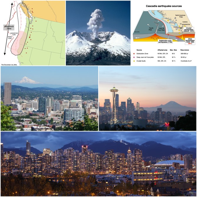
Only since the 1980s have researchers and geologists begun to finally agree that the Cascadia Subduction Zone will eventually lead to a major earthquake and subsequent tsunami for the U.S. West Coast. The zone, which runs from Vancouver Island to the top of California, runs the risk of potential earthquakes due to the meeting of the North American and Oceanic Plates. At this meeting place, the heavier oceanic plates are being forced under the North American plates in a process called subduction (top left picture). At the Cascadia Subduction Zone, however, the plates have become locked and are no longer moving to release pressure. By not releasing this stress with minor earthquakes, the zone runs the imminent risk of ‘snapping-back’ once the pressure becomes too great (top right picture). When this snap-back finally does occur, the resulting earthquake will be devastating (likely registering at around a 9.0 in magnitude) and send tsunami waves crashing into much of the Northwest Coast of the United States.As seen in many of the pictures, the Western Coast of the U.S. is heavily populated and such an earthquake would be devastating with FEMA estimating 10,000 deaths and one million without homes after such a disaster.
While the history of the zone is hard to truly know, recent research suggests that the zone has caused an earthquake of 8.0 or greater magnitude seven times in the last 3000 years. The last of these being traced to around 1700 with various native tribes depicting such a disaster in their oral histories. While such folklore were originally not accepted by researchers, corroborating histories of ‘orphan tsunamis’ in Japan at the same time as well as subsequent research into ‘ghost forests’ on the west coast have helped to provide the true history of the area.
With this newfound acceptance of the history, much effort has been exerted in trying to forecast the timing of the next major earthquake. As of 2010, it has been reported that there is around a one-in-three risk of a major earthquake (8.0 or greater) in the next 50 years. Even with the vast amount of time and money devoted to studying and forecasting the imminent threat of tsunamis, the country is still not adequately prepared for the damage that will no doubt occur from such a disaster. Citizens in the U.S. are apathetic in taking proper precaution likely because they have never experienced such a disaster on their coastline. They have not experienced the widespread damage caused by tsunami risks (unlike those in Japan) and thus are unmotivated to devote the time to precaution. With some luck, the zone will not cause a massive earthquake anytime soon and allow the country more time to organize for such a disaster. If the event does happen in the next 50 years it will likely cause considerable panic and destruction along the West Coast. It is very difficult, unfortunately, to put attention towards a risk that the public has never experienced. For this reason, it is likely that only after massive destruction occurs, will Americans began to understand the risks, but at that point it will be too late.
The North American seismic hazard that has the greatest potential risk for the continent is the Cascadia Subduction Zone. This subduction zone is located in the west coast of the continent along Vancouver Island and U.S. states, Washington, Oregon, and California. This subduction zone was formed after the Pacific Plate and Juan de Fuca Plate collided and the softer oceanic crust gave way to the continental crust and sunk into the mantel. The pressure and mantle upwelling causes the Pacific Plate and the Juan de Fuca Plate to be pushed apart. This is causing the Juan de Fuca Plate to the forced under the North American Plate thus creating the Cascadia Subduction Zone. Just because a subduction zone is formed does not mean there is automatically seismic stress created. If there is enough lubrication the plate can continue to side easy under the other plate. In the case of the Cascadia Subduction Zone, the plates have become locked about thirty to sixty kilometers underneath the surface and are building up pressure. Eventually the plate will slip in which case there is potential for an Earthquake of 9.0+ magnitude. This event would trigger a massive tsunami which would wreak havoc upon the North West coast of the United States and Vancouver and leave little time for warning. Scientists have discovered evidence for this evident occurring historically. It was first heard about from the Native population through oral story telling traditions. They told stories of a giant wave and the disappearance of cities. These stories were largely ignored at first then more evidence was discovered. Through stratigraphy, Geologist were able to find ghost forests which are areas of forest that were drowned all at the same. Also, during the same short period, the layer of sand was found within this area of inland forest. Both the native stories and the stratigraphic finding both point to this subduction zone induced earthquake and tsunami to have occurred around 1700. Evidence shows that the tsunami was 45 feet tall. Through further research, scientists found that this occurrence has a periodicity of 300 to 500 years which means the chances of these plates releasing their built up pressure is very high over the next 200 years. Some scientists say that there is 30% chance this will occur within the next fifty years. This area of the west coast usually experiences no seismic activity which means there is very little mitigation in place for this kind of disaster. Movements are forming to get the public more aware of this potential disaster and work to start minimizing risk.
Even though the West coast is part of the ring of fire, with the exception of southern California, this particular region is not usually in the mind of the public as such a volatile region for seismic activities, yet historical records, and recent studies have shown that the Cascadia zone, covering from Vancouver to Northern California, can eventually be a region of such seismic and tsunami activity that turns the whole region into chaos, without that much of a warning.
While legends of giant waves that swallowed cities and forest whole, have always existed among the Native American tribes of that region, said legends had been all but ignored by Western researchers, until the recent discoveries of Petrified Forest gave archaeological evidence of said legends, prompting researchers to dig deeper into these subjects.
After a more in depth research by scientists in the late 1980’s have shown that the Cascadia zone has the potential to experience long lasting earthquakes of 9.0 in Richter’s scale, thus creating a catastrophe of never seen proportions in the United States. While the San Andreas fault gets most of the attention, recent earthquakes in Ecuador and Japan, have shown the potential catastrophic disaster of an earthquake/tsunami hitting an unprepared zone, thus warning that is only a matter of time, before the western coast of the US and Canada, becomes one of the worst catastrophe’s in the modern times, as these cities not normally used to earthquakes, could experience some of the worst seismic activity seen in the North American continent in recorded history.
The Cascadia Subduction Zone poses extreme risk to the Pacific-Northwest. The already active volcanism in the area, along with a massive fault locked 30-60km under the surface just off the coast. The fact that the locked point is under the ocean surface increases the threat to this coastal region, as it is not only earthquakes that pose a threat, but also the risk of a massive tsunami. The cascadia subduction zone is the result of the subduction of the Juan de Fuca plate underneath the North American Plate. This kind of natural disaster was cataloged by many First Nations groups throughout the region, and also within Japanese oral tradition, to have occurred around 1700 leading to a massive megathrust earthquake in the Pacific-Northwest, and also led to a large “orphan tsunami” to impact Japan, killing large amounts of people. Dendrochronology has allowed us to explore and find evidence of the event through the discovery and analysis of ghost forests, along with sediment layers exposing peculiar layers of sand far from the coast. The unlocking of the plate jam has the potential to produce around a 9.0 earthquake which could be truly devastating to areas that have not undergone proper disaster mitigation. The most at risk areas area the coastal region of Oregon and the city of Vancouver, which are both scheduled to be directly hit by the first tsunami wave within 6 minutes of its formation, which gives very little time for a metropolis city like Vancouver to evacuate its 600,000+ citizens. The same is true for coastal Oregon, but the metropolis factor is not quite the same as in Vancouver. The city of Seattle is perhaps the best and worst place to be when the plate unlocks, as the tsunami impact time is much slower than other areas, as Seattle lies within the Puget Sound, but the earthquakes still pose a risk, as well as the idea of evacuation. If everyone floods (no pun intended) to evacuate the city all at once, a tsunami could potentially reach citizens when at their most vulnerable moment within their vehicles, rather than a place where one can take shelter from a tsunami, post-earthquake. The area of Capitol Hill may actually be one of the safest urban places within this region to be in this situation, as the wave height and impact is low, and the buildings are relatively small and stable, possibly able to endure a violent earthquake. Overall, the potential risk of the Cascadia Earthquake and Tsunami should not be taken lightly, and immense planning and mitigation should be done to ensure the safety of the communities at risk.
The Pacific Northwest is one of my favorite parts of the United States. The ferry boat rides in Seattle, the view of Canada across the Straight of Juan de Fuca from Port Angeles, the sunset on the Pacific in Ocean Shores, all these spots are directly at risk of significant damage when the seismic event created by the Cascadia Subduction Zone occurs.
I too did not know about this seismic zone before this class, and I’m sure I looked wide eyed while we discussed the ramifications this earthquake could have. Because the Pacific plate is pushing the Juan de Fuca plate under the North American Plate there is a great amount of built up stress. We have learned that the stress has been released in the form of an earthquake and subsequent tsunami in the past. Cores show that this occurs every 300-500 years, and we are due for a reoccurrence relatively soon.
There was not a lot of damage the last time this happened, but in our usual style we have built up a large amount of risk, like we learned in class, atop of this hazardous coast. While the hazard has not changed, we have increased risk with our actions. The south pacific coast of Canada, Washington, Oregon, and Northern California could all be impacted by a massive tsunami when this situation blows. Not only are there tons of buildings, roads, and people in the line of fire, but this part of the Pacific coast is not used to seismic activity. Unlike Southern California which is accustomed to Earthquakes multiple times a year, the Pacific Northwest has seismic events once in a few generations. The state of the buildings on the coast are overall unprepared for what could come. In recent years, people have been constructing the new buildings with precaution of this possibility, but there are millions of buildings that are too old and costly to be fixed. Lives will be lost when this happens. While, the probability is small right now, those who live in zones that would be quickly destroyed by a tsunami should be prepared with plans of action in the event they live through what will most likely be a historic disaster.
While the Pacific has a good system in place to alert people of impending danger, when this earthquake happens, there will be very little time to get to a safe place. Minutes stand between the initial earthquake and when the tsunami would hit, allowing virtually no time to get significantly further inland. Furthermore, cities like Seattle, for example, are not well suited for mass evacuation, not because of bad planning, but simply because of the shape of the land. The moral of the story is if you are going to move to the PNW, make sure to buy land on a very tall hill.

The Cascadia Subduction Zone…I had no idea that it existed before this class. Even though the hazard that is present in this region is interesting, I think the history behind identifying the area as a subduction zone. If I happened upon a ghost forest that was hundreds of years old, I wouldn’t have been able to connect that with a subduction zone that sets of massive earthquakes every 300-700 years, without setting of minor earthquakes every now and then like most other subduction zones. Then, being able to corroborate the orphan tsunami in Japan from 1700 with the ghost forests and stories among Native American groups is astounding to me.
Applying the results of the last Cascadia earthquake/tsunami to a potential incident today, the results would be devastating. Because the timing of the incidents is so far apart, and many of the buildings that were there are older than the discovery of the Cascadia Subduction Zone in the 1970s, I can’t even fathom the amount of destruction that would occur because of bad building, lack of planning, and human hazard. As we can see in these photos, cities in this area are densely populated, with many large buildings, most of which were not built with a massive earthquake in mind…or to withstand the force of a subsequent tsunami. Of course there are ways to prepare for it by building new buildings using sturdier materials, creating evacuation plans, and increasing education on earthquake and tsunami safety. However, there are some things that can’t be changed: buildings that are in lower areas, for instance, have a greater risk for tsunami damage. Buildings that were built without earthquake mitigation probably won’t undergo said mitigation as it is incredibly expensive. And of course, some people won’t care that there is a potential for a mega-earthquake and subsequent tsunami because the likelihood it will happen while they are in the risk area is too small for them to care (even though they should).
With the recent earthquakes in Japan and Ecuador, also in the Ring of Fire, there was definitely an increase in media coverage of the Cascadia Subduction Zone. We mentioned in class that the San Andreas fault gets more attention because it has more earthquakes, but those earthquakes are smaller and less damaging. Plus, earthquakes along the San Andreas fault last only a few seconds, maybe up to 30. The potential length of a so-called mega earthquake along the Cascadia Rift could last for minutes, as it is 9.0+ on the Richter Scale. Such coverage is good. It’s incredibly important that people who live in these areas, and those that visit there, know the risk involved, even if the likelihood that a seismic event occurs while they are there is slim-to-none.
Good discussion, I’m glad you are now aware of this risk 🙂
Only since the 1980s have researchers and geologists begun to finally agree that the Cascadia Subduction Zone will eventually lead to a major earthquake and subsequent tsunami for the U.S. West Coast. The zone, which runs from Vancouver Island to the top of California, runs the risk of potential earthquakes due to the meeting of the North American and Oceanic Plates. At this meeting place, the heavier oceanic plates are being forced under the North American plates in a process called subduction (top left picture). At the Cascadia Subduction Zone, however, the plates have become locked and are no longer moving to release pressure. By not releasing this stress with minor earthquakes, the zone runs the imminent risk of ‘snapping-back’ once the pressure becomes too great (top right picture). When this snap-back finally does occur, the resulting earthquake will be devastating (likely registering at around a 9.0 in magnitude) and send tsunami waves crashing into much of the Northwest Coast of the United States.As seen in many of the pictures, the Western Coast of the U.S. is heavily populated and such an earthquake would be devastating with FEMA estimating 10,000 deaths and one million without homes after such a disaster.
While the history of the zone is hard to truly know, recent research suggests that the zone has caused an earthquake of 8.0 or greater magnitude seven times in the last 3000 years. The last of these being traced to around 1700 with various native tribes depicting such a disaster in their oral histories. While such folklore were originally not accepted by researchers, corroborating histories of ‘orphan tsunamis’ in Japan at the same time as well as subsequent research into ‘ghost forests’ on the west coast have helped to provide the true history of the area.
With this newfound acceptance of the history, much effort has been exerted in trying to forecast the timing of the next major earthquake. As of 2010, it has been reported that there is around a one-in-three risk of a major earthquake (8.0 or greater) in the next 50 years. Even with the vast amount of time and money devoted to studying and forecasting the imminent threat of tsunamis, the country is still not adequately prepared for the damage that will no doubt occur from such a disaster. Citizens in the U.S. are apathetic in taking proper precaution likely because they have never experienced such a disaster on their coastline. They have not experienced the widespread damage caused by tsunami risks (unlike those in Japan) and thus are unmotivated to devote the time to precaution. With some luck, the zone will not cause a massive earthquake anytime soon and allow the country more time to organize for such a disaster. If the event does happen in the next 50 years it will likely cause considerable panic and destruction along the West Coast. It is very difficult, unfortunately, to put attention towards a risk that the public has never experienced. For this reason, it is likely that only after massive destruction occurs, will Americans began to understand the risks, but at that point it will be too late.
Very good, especially your discussion of the inability to deal with the risk.
The North American seismic hazard that has the greatest potential risk for the continent is the Cascadia Subduction Zone. This subduction zone is located in the west coast of the continent along Vancouver Island and U.S. states, Washington, Oregon, and California. This subduction zone was formed after the Pacific Plate and Juan de Fuca Plate collided and the softer oceanic crust gave way to the continental crust and sunk into the mantel. The pressure and mantle upwelling causes the Pacific Plate and the Juan de Fuca Plate to be pushed apart. This is causing the Juan de Fuca Plate to the forced under the North American Plate thus creating the Cascadia Subduction Zone. Just because a subduction zone is formed does not mean there is automatically seismic stress created. If there is enough lubrication the plate can continue to side easy under the other plate. In the case of the Cascadia Subduction Zone, the plates have become locked about thirty to sixty kilometers underneath the surface and are building up pressure. Eventually the plate will slip in which case there is potential for an Earthquake of 9.0+ magnitude. This event would trigger a massive tsunami which would wreak havoc upon the North West coast of the United States and Vancouver and leave little time for warning. Scientists have discovered evidence for this evident occurring historically. It was first heard about from the Native population through oral story telling traditions. They told stories of a giant wave and the disappearance of cities. These stories were largely ignored at first then more evidence was discovered. Through stratigraphy, Geologist were able to find ghost forests which are areas of forest that were drowned all at the same. Also, during the same short period, the layer of sand was found within this area of inland forest. Both the native stories and the stratigraphic finding both point to this subduction zone induced earthquake and tsunami to have occurred around 1700. Evidence shows that the tsunami was 45 feet tall. Through further research, scientists found that this occurrence has a periodicity of 300 to 500 years which means the chances of these plates releasing their built up pressure is very high over the next 200 years. Some scientists say that there is 30% chance this will occur within the next fifty years. This area of the west coast usually experiences no seismic activity which means there is very little mitigation in place for this kind of disaster. Movements are forming to get the public more aware of this potential disaster and work to start minimizing risk.
Nice discussion
Even though the West coast is part of the ring of fire, with the exception of southern California, this particular region is not usually in the mind of the public as such a volatile region for seismic activities, yet historical records, and recent studies have shown that the Cascadia zone, covering from Vancouver to Northern California, can eventually be a region of such seismic and tsunami activity that turns the whole region into chaos, without that much of a warning.
While legends of giant waves that swallowed cities and forest whole, have always existed among the Native American tribes of that region, said legends had been all but ignored by Western researchers, until the recent discoveries of Petrified Forest gave archaeological evidence of said legends, prompting researchers to dig deeper into these subjects.
After a more in depth research by scientists in the late 1980’s have shown that the Cascadia zone has the potential to experience long lasting earthquakes of 9.0 in Richter’s scale, thus creating a catastrophe of never seen proportions in the United States. While the San Andreas fault gets most of the attention, recent earthquakes in Ecuador and Japan, have shown the potential catastrophic disaster of an earthquake/tsunami hitting an unprepared zone, thus warning that is only a matter of time, before the western coast of the US and Canada, becomes one of the worst catastrophe’s in the modern times, as these cities not normally used to earthquakes, could experience some of the worst seismic activity seen in the North American continent in recorded history.
Good discussion
The Cascadia Subduction Zone poses extreme risk to the Pacific-Northwest. The already active volcanism in the area, along with a massive fault locked 30-60km under the surface just off the coast. The fact that the locked point is under the ocean surface increases the threat to this coastal region, as it is not only earthquakes that pose a threat, but also the risk of a massive tsunami. The cascadia subduction zone is the result of the subduction of the Juan de Fuca plate underneath the North American Plate. This kind of natural disaster was cataloged by many First Nations groups throughout the region, and also within Japanese oral tradition, to have occurred around 1700 leading to a massive megathrust earthquake in the Pacific-Northwest, and also led to a large “orphan tsunami” to impact Japan, killing large amounts of people. Dendrochronology has allowed us to explore and find evidence of the event through the discovery and analysis of ghost forests, along with sediment layers exposing peculiar layers of sand far from the coast. The unlocking of the plate jam has the potential to produce around a 9.0 earthquake which could be truly devastating to areas that have not undergone proper disaster mitigation. The most at risk areas area the coastal region of Oregon and the city of Vancouver, which are both scheduled to be directly hit by the first tsunami wave within 6 minutes of its formation, which gives very little time for a metropolis city like Vancouver to evacuate its 600,000+ citizens. The same is true for coastal Oregon, but the metropolis factor is not quite the same as in Vancouver. The city of Seattle is perhaps the best and worst place to be when the plate unlocks, as the tsunami impact time is much slower than other areas, as Seattle lies within the Puget Sound, but the earthquakes still pose a risk, as well as the idea of evacuation. If everyone floods (no pun intended) to evacuate the city all at once, a tsunami could potentially reach citizens when at their most vulnerable moment within their vehicles, rather than a place where one can take shelter from a tsunami, post-earthquake. The area of Capitol Hill may actually be one of the safest urban places within this region to be in this situation, as the wave height and impact is low, and the buildings are relatively small and stable, possibly able to endure a violent earthquake. Overall, the potential risk of the Cascadia Earthquake and Tsunami should not be taken lightly, and immense planning and mitigation should be done to ensure the safety of the communities at risk.
Good discussion and analysis of potential risk.
The Pacific Northwest is one of my favorite parts of the United States. The ferry boat rides in Seattle, the view of Canada across the Straight of Juan de Fuca from Port Angeles, the sunset on the Pacific in Ocean Shores, all these spots are directly at risk of significant damage when the seismic event created by the Cascadia Subduction Zone occurs.
I too did not know about this seismic zone before this class, and I’m sure I looked wide eyed while we discussed the ramifications this earthquake could have. Because the Pacific plate is pushing the Juan de Fuca plate under the North American Plate there is a great amount of built up stress. We have learned that the stress has been released in the form of an earthquake and subsequent tsunami in the past. Cores show that this occurs every 300-500 years, and we are due for a reoccurrence relatively soon.
There was not a lot of damage the last time this happened, but in our usual style we have built up a large amount of risk, like we learned in class, atop of this hazardous coast. While the hazard has not changed, we have increased risk with our actions. The south pacific coast of Canada, Washington, Oregon, and Northern California could all be impacted by a massive tsunami when this situation blows. Not only are there tons of buildings, roads, and people in the line of fire, but this part of the Pacific coast is not used to seismic activity. Unlike Southern California which is accustomed to Earthquakes multiple times a year, the Pacific Northwest has seismic events once in a few generations. The state of the buildings on the coast are overall unprepared for what could come. In recent years, people have been constructing the new buildings with precaution of this possibility, but there are millions of buildings that are too old and costly to be fixed. Lives will be lost when this happens. While, the probability is small right now, those who live in zones that would be quickly destroyed by a tsunami should be prepared with plans of action in the event they live through what will most likely be a historic disaster.
While the Pacific has a good system in place to alert people of impending danger, when this earthquake happens, there will be very little time to get to a safe place. Minutes stand between the initial earthquake and when the tsunami would hit, allowing virtually no time to get significantly further inland. Furthermore, cities like Seattle, for example, are not well suited for mass evacuation, not because of bad planning, but simply because of the shape of the land. The moral of the story is if you are going to move to the PNW, make sure to buy land on a very tall hill.
Good discussion.