This is the Hereford Mappa Mundi: use the images to discuss how the church influenced geographic thinking 9and science in general) in the Middle Ages in Europe. 500 words or more…
This is the Hereford Mappa Mundi: use the images to discuss how the church influenced geographic thinking 9and science in general) in the Middle Ages in Europe. 500 words or more…

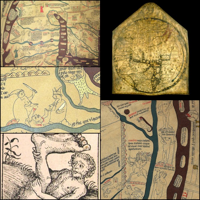
The Hereford Mappa Mundi is an impressive work. It depicts hundreds of cities, creatures, and biblical stories in very great detail. Not only is it a geographic interpretation of the world, it is also a spiritual interpretation. The map gives us a window into the cultural, religious, and mythological ideas of the time period. Looking at the various depictions like Jesus at the top and the fact that the entire map is centered around Jerusalem shows that the bible was very important. We even see that the map is oriented with east at the top. (This was believed to be the direction of Eden, the rising sun, and the direction Jesus would come back from.) However, it also is a vivid example of the close-minded thinking which retarded the advance of geography and other sciences during this era.
This map is another T and O map, which focuses on only the 3 continents mentioned in the bible, given to each of Noah’s sons. The world outside of this area was considered unknown and “supernatural.” However not all of this ignorance can be blamed on the Christian church. Also depicted are strange beasts and classical mythology: a troglodyte riding a goat beast, a headless Blemmys, a Unicorn, a Minataur, Golden Fleece, and the Pillars of Hercules near the southern end of Spain which was sort of the “bottom of the world.” These have nothing to do with the bible or Christian beliefs.
When I look at Greek maps, I see highly intellectual academic thought and a focus on understanding the world. The Greeks were interested in measuring the Earth’s size, shape, and physical characteristics. They even went as far as to understand how latitude effects climate. When I see Roman maps I see very practical regional maps made for trade, travel, and administration. When I look at this map I see a shift from logical, intellectual, and practical thought, to a map focused on myth and spirituality. Instead of rational explanations for things there must always be some sort of strange force or beast in the next land over as the cause. From what I can gather, it seems to me that the few literate people during this time favored the tall tales and wacky exaggerated stories form far away travelers. Either that, or the knowledge and literary works from the previous era were lost and simply unavailable for people to even make the attempt to educate themselves properly. These elite folks who were in charge during this time seem to be very ignorant to rational thought. Because of this we end up with a map that looks like it was combined with a Christian monks visions while he was on meth. I imagine the modern equivalent of this map to be one with aliens, UFO’s, and the Illuminati on it. Some people today see religions like Christianity as a threat to rational thinking. It appears that in this time, oppositely, the people in power saw scientific thinking as a threat to their religious beliefs. There was almost no tolerance to those people that had varying interpretations of the bible—which may have aligned more with the research of academics before the fall of Rome.
Meth monks! I like that…
The Hereford Mappa Mundi is an impressive work. It depicts hundreds of cities, creatures, and biblical stories in very great detail. Not only is it a geographic interpretation of the world, it is also a spiritual interpretation. The map gives us a window into the cultural, religious, and mythological ideas of the time period. Looking at the various depictions like Jesus at the top and the fact that the entire map is centered around Jerusalem shows that the bible was very important. We even see that the map is oriented with East at the top. (This was believed to be the direction of Eden, the rising sun, and the direction Jesus would come back from.) However, it also is a vivid example of the close-minded thinking which retarded the advance of geography and other sciences during this era.
This map is another T and O map, which focuses on only the 3 continents mentioned in the bible, given to each of Noah’s sons. The world outside of this area was considered unknown and “supernatural.” However not all of this ignorance can be blamed on the Christian church. Also depicted are strange beats and classical mythology: a troglodyte riding a goat beast, a headless Blemmys, a Unicorn, a Minataur, Golden Fleece, and the Pillars of Hercules near the southern end of Spain which was sort of the “bottom of the world.” These have nothing to do with the bible or Christian beliefs.
When I look at Greek maps, I see highly intellectual academic thought and a focus on understanding the world. Greeks were interested in measuring the Earth’s size, shape, and physical characteristics. They even went as far as to understand how latitude effects climate. When I see Roman maps I see very practical regional maps made for trade, travel, and administration. When I look at this map I see a shift from logical, intellectual, and practical thought, to a map focused on myth and spirituality. Instead of rational explanations for things there must always be some sort of strange force or beast in the next land over as the cause. From what I can gather, it seems to me that the few literate people during this time favored the tall tales and wacky exaggerated stories form far away travelers. Either that, or the knowledge and literary works from the previous era were lost and simply unavailable for people to even make the attempt to educate themselves properly. These elite folks who were in charge during this time seem to be very ignorant to rational thought. Because of this we end up with a map that looks like it was combined with a Christian monks visions while he was on meth. I imagine the modern equivalent of this map to be one with aliens, UFO’s, and the Illuminati on it.
Many people today see religions like Christianity as a threat to rational thinking. It appears that in this time, oppositely, the people in power saw scientific thinking as a threat to their religious beliefs. There was almost no tolerance to those people that had varying interpretations of the bible—which may have aligned more with the research of academics before the fall of Rome.
Christians and their adopted ideas! I really like this map for a number of reasons but it definitely is not for the high quality in the actual figures and buildings. It is large and elaborate but reminds me of the simple drawings around the edges of a Dungeons and Dragons manual in the 80s. The orientation of the drawings and the buildings is also a bit unusual but understandable when you consider how many different things are represented in this world. This is one of the most Borg images I have ever seen in a Christian document. We have a Palestinian Jew at the top, along with the Garden of Eden both of which are in their correct places in the east. Of course this is also the place where you will find the morning star (Lucifer) which is somewhat amusing since the Christ also refers to himself as the morning star in Revelations.
The reason for referring to this creation as Borg in nature is because of the many non-Christian beliefs that are wrapped up in the images. First are the strange peoples of the world: the headless akephaloi (Greek) Blemmyes (Latin) peoples of North Africa, the Skiapodes (Greek) Monopods (Latin) who shade themselves with their feet, and the Cynocephali (a Greek and Latin mishmash) who have the heads of jackals. These people are not really biblical in nature and I find it amusing that they are included. Next, we have to look at the columns of Hercules, the Golden Fleece, and the Labyrinth, why are these MENA region myths and legends included in a Christian map of the known world? Did the cartographer consider whether they were included in the bible? It seems that to even put these items on a map destined to be placed in a cathedral would be considered blasphemy. Most confusing of these three is the labyrinth which is actually coming back into fashion over the past 30 years or so as a way to be closer to Yahweh. Labyrinths are common in many world religions but not in early Christianity.
Once you get past the borrowed ideas and symbolism and really just look at the beauty of this oriental map you can see that it was a work of faith and love. The labeling is done in a beautifully straight and consistent Latin that looks like art by itself. The coloring of the features using red, blue and green would have needed both rare materials and endless hours of preparation. The ink used in the writing is still clear and relatively not faded considering that they are about 700 years old. Furthermore, the shape of the map resembles a house or cathedral as if the artist is implying that it is just as much a map of “God’s” house as it is a map of the world. One striking aspect is how Jerusalem is portrayed as an overhead view instead of the simplified front view of all other cities. This might be the work of a different artist or maybe this artist copied someone else’s work. Strangely though, the labyrinth is the only other building or structure drawn from this perspective. I do not know if this is significant but was intrigued by how different these two features are from the rest of the map.
The Mappa Mundi as interpreted by a nerd….I like this…nicely done.
Like the other two commenters above me, it would be remiss to start a discussion on the Hereford Mappa Mundi without at least mentioning a few obvious structural elements. The map is a T-O structure, centered on Jerusalem and oriented with East at the top. A percipient of this map can easily orient themselves in a general sense by using a bottom-left to top-right line, with Europe and the British Isles at the bottom left and the Red Sea (appearing in vivid blood red color) at the top right. Africa resides to the right edge of the map, although the extent to which Africa is mapped is limited. Asia is towards the top of the map, and is similarly limited in its extent.
It is abundantly clear after only a few moments observing the map that it is not geographically correct. The map’s scale and depiction of mythical and religious objects are two obvious indicators that this map would not be of any use for navigation purposes. However, it is clear that the Hereford Mappa Mundi was not intended as a navigation tool, but as a device to communicate relationships and stories that the cartographer deemed of importance. When viewed in its entirety, the map appears as a storied visualization of a ‘fictional’ world rather than a navigational product. Great detail was invested into the caricatures, text, and symbols rather than the geographic accuracy.
The students above me have noted that Jerusalem is in the center of the map and the Garden of Eden is displayed as a physical landmass at the top, or the East. Just these two features along clue the percipient into the worldview of the cartographer where a Biblical narrative is front and center. The use of vivid colors in combination with exaggerated river/water sizes contributes to natural eye movement from the center outwards, tracing biblical stories, church structures, and symbolic images alongside the riverbanks. The entire known world being surrounded by water and angel-like figures also contributes to the sense that the Earth is contained and at the mercy of the heavens. I can easily picture this map being used as an illustration tool to share biblical stories and place them in the context of the world at the time. These stories and locations wouldn’t have been geographically accurate, but they didn’t need to be geographically accurate if they were biblically accurate.
With limited space on any map, the choice of images gives insight into what objects and ideas were selected as important. The dominant features in the Hereford Mappa Mundi are buildings, with many appearing to be religious buildings or churches. The extent to which churches are depicted helps reinforce the church’s influence over physical space. The buildings also help show where Western civilization was centered, as the structures transition into mythical figures towards Africa and Asia. This may have also been an intentional statement towards Islam, which strictly prohibits the depiction of the divine symbols. It becomes clear in transitioning between the three distinct portions in the T-O structure that the three continents are portrayed as symbolically different.
Very nice discussion.
I would assume and hope that nobody ever tried to use this as a navigation tool and like the other commentators, I would argue that the Mappa Mundi Hereford is a work of art and literature more than anything. Specifically, it’s early science fiction. The map features span the categories of science, fantasy, and religion and it is hard to know by looking at it today exactly which aspects of the map were intended by the artist for which categories.
Compared with today’s standards, this map is obviously not that accurate. By 13th century standards however it did a pretty good job, especially keeping in mind that it was a work of art and not a tool. The piece depicts hydrography, major settlements, routes, and the gist of coastlines and landmasses, with those areas furthest from Europe and the Mediterranean being the least accurate. In these less known areas, Richard of Haldingham, the artist, filled in unknowns with what appear to be a combination of fantasy/mythology and religion.
The Christian religious presence is strong in the map as it was in everyday life. Jerusalem is located at the center, the orientation is east with an image of Jesus just beyond the Garden of Eden on top of the world, and there are several biblical events depicted throughout the continents. The effect of the church on the stagnation of science and education during this time was huge and the lack of improvements in the accuracy of this map compared to maps from hundreds of years earlier makes that evident. I do not think that the religious aspects of this map undermine the beauty or impressive physical detail however. In fact a lot of this is pretty arbitrary. Jerusalem may not be at the center of the Earth but neither is Greenwich, England. The top of the world may not be to the East but it’s not to the North either. And while the biblical events represented on the map were very important to people of this time period, they are often inseparable from the scenes of mythology and fantasy. Whether these fell into the science category or the fantasy category for the artist is hard to say and frankly begs to be compared with the imaginary political boundaries that overshadow the physical aspects on many maps produced today.
In a time and place where religion trumped science and education was discouraged for fear by the church that folks might become too wise, science and reason certainly suffered. However, I’m not sure that this piece of art is the best example of that. I would agree, as another comment mentions, that the map was likely used as a visual representation for the telling of bible stories and I would extend this speculation to include other stories as well. It would be hard to say that this was ever intended to be anything more than a work of science fiction and art created within a worldview where Christianity was synonymous with truth.
Early science fiction, I like that observation.
I would assume and hope that nobody ever tried to use this as a navigation tool and like the other commentators, I would argue that the Mappa Mundi Hereford is a work of art and literature more than anything. Specifically, it’s early science fiction. The map features span the categories of science, fantasy, and religion and it is hard to know by looking at it today exactly which aspects of the map were intended by the artsist for which categories.
Compared with today’s standards, this map is obviously not that accurate. By 13th century standards however it did a pretty good job, especially keeping in mind that it was a work of art and not a tool. The piece depicts hydrography, major settlements, routes, and the gist of coastlines and landmasses, with those areas furthest from Europe and the Mediterranean being the least accurate. In these less known areas, Richard of Haldingham, the artist, filled in unknowns with what appear to be a combination of fantasy/mythology and religion.
The Christian religious presence is strong in the map as it was in everyday life. Jerusalem is located at the center, the orientation is east with an image of Jesus just beyond the Garden of Eden on top of the world, and there are several biblical events depicted throughout the continents. The effect of the church on the stagnation of science and education during this time was huge and the lack of improvements in the accuracy of this map compared to maps from hundreds of years earlier makes that evident. I do not think that the religious aspects of this map undermine the beauty or impressive physical detail however. In fact a lot of this is pretty arbitrary. Jerusalem may not be at the center of the Earth but neither is Greenwich, England. The top of the world may not be to the East but it’s not to the North either. And while the biblical events represented on the map were very important to people of this time period, they are often inseparable from the scenes of mythology and fantasy. Whether these fell into the science category or the fantasy category for the artist is hard to say and frankly begs to be compared with the imaginary political boundaries that overshadow the physical aspects on many maps produced today.
In a time and place where religion trumped science and education was discouraged for fear by the church that folks might become too wise, science and reason certainly suffered. However, I’m not sure that this piece of art is the best example of that. I would agree, as another comment mentions, that the map was likely used as a visual representation for the telling of bible stories and I would extend this speculation to include other stories as well. It would be hard to say that this was ever intended to be anything more than a work of science fiction and art created within a worldview where Christianity was synonymous with truth.
The Hereford Mappa Mundi is a map that attempts to provide a basic geographical understanding of the world while also showing the, mostly Christian but not always, mythology of the time through a wide range of symbols, scriptures, and images. For instance, we see a crucifix above Jerusalem, Noah’s Ark, and other illustrations all over the map representing various events from the Bible. At the very top of the map is Jesus, with the angels and saints beneath him, and heaven on his right and hell on his left. While focused on Christianity, there’s also mythology from other cultures, such as a representation of Jason and the Argonauts and the Columns of Hercules.
One interesting aspect of this map is its orientation. At the time, there was no standard direction for maps to face, so it changed depending on who made it. For instance, the Chinese made a lot of their maps with the south on top. On the Hereford Mappa Mundi, the map has east on top because that is the direction of both the rising Sun and Christ’s return. This is as valid as any other direction of the time, but what is interesting is that the map is not centered on the western world it originates from, nor the center of the known world, but rather on Jerusalem due to its importance in Christian history.
Geographically, everything on the Hereford Mappa Mundi is so distorted to fit the orientation and layout desired by its creator that the map is almost unrecognizable at first, even compared to maps from previous centuries. Though it does show basic relationships, such as the relative location of various parts of the world, it is certainly not fit for navigation or in-depth spatial studies. Landmasses are, at best, representative only relative to their neighbors and bodies of water have drastically different shapes and connections from what was known at the time. In general, the cartographer seems to have let their artistic ambitions, or perhaps just their laziness, control the design of this map to the point of it being almost useless as a world reference, though there is no denying the artistic effort put into it.
Rather than focus on accuracy, the focus of this map is on culture, which is also largely representative of the Church’s focus, and therefore influence, on the world at the time. The Church was largely focused on the mythos and stories of the world during the Middle Ages instead of the sciences. For instance, though Christian focused, we do see images that don’t represent Christian mythology on the Hereford Mappa Mundi, but are important to some cultures, or least have historical significance. Because the Church controlled most of western education, the works from that time period are highly representative of this focus on culture and mythos. This is an example of the dangers of a single entity of any culture, religion, or belief, controlling something as vital as the educational system, especially for half the world. There’s nothing wrong with some educational institutions focusing on culture and art, but with no entity to put empirical studies first, there was a considerable amount of time and potential discovery that was lost.
Good observation about the focus on culture rather than accuracy.
It is important to emphasize that education during the Middle Ages was largely dominated by the Church. Any person who made a relevant discovery through the use of science was considered to be a heretic – a person whose beliefs and doings did not go in accordance with what the church dictated. The majority of the elements contained in the Hereford Mappa Mundi are of a spiritual and religious nature. These features were inspired in the use of biblical tales and the location of religious places. Among some of these religious features can be mentioned: the location Jerusalem in the middle of the map and Christ on the day of the final judgement. However, it also contains some other elements of geographical importance for the development of the places represented in this map. Historically and geographically speaking the development of civilizations occurs in areas close to rivers and other water reservoirs. These cities are called hydraulic cities. The Hereford Mappa Mundi does a great job representing these bodies of water. Cartographically speaking this map does not contain basic elements such as a north arrow and the placement of its orientation was not made in a way that leads to think that north is at the top, south is located at the bottom, the west on the left and the east to the right. The misplacement of north, south, east and west makes the use of this map complicated for navigational purposes.
The obstacles imposed by the church might have had a lot to do on the quality of the Hereford Mappa Mundi and the development of science in general. This is proven, when we observe the good quality and the approximation with regard to existence and correct placement of continental masses that is portrayed in the Reconstruction of Hecataeus’ map. Even though Hecataeus’ Map does not show the American continent, it has a clear idea of the proper location of Asia, Europe and Africa. The elaboration of this map was eight hundred years prior to the creation of Hereford Mappa Mundi. It is evident by 600 BCE (when Hecataeus’ Map was created), there were less advances in terms of science for the creation of Map. I am not referring to the Hereford Mappa Mundi as map of bad quality. On the contrary, the work made by Hereford is more meaningful since he had to deal with the obstacles imposed by the church, which had control over almost everything. However, I consider that there were more available tools during the Middle Ages to have created a map that represented the world in a more precise way than the Hecataeus’ Map. A tool that would have allowed for the creation of a more accurate Hereford map and that existed at that time was use of better and improved ships. The Middle Ages is a time in which many explorations were made by Europeans. These trips would’ve allowed Hereford to establish better coastlines and the more precise of placement of continental masses in his Mappa Mundi. As I mentioned at the beginning of my post, I think that the Hereford Mappa Mundi is a clear representation of what might have been the obstacles imposed by the church during the Middle Ages. I based my answer comparing the quality of the Hereford Mappa Mundi and the Reconstruction of Hecataeus’ map. I am not certain for which purpose each of the maps was built. Maybe, the purpose of the Hereford Mappa Mundi was indeed created as a representation of biblical tales and the church.
If we take a closer look at Hereford Mappa Mundi we can notice that it contains a lot of writings. According to Ben Johnson (Historic UK), these writings on the map could only be read by people who were able to speak Norman French. This tells us that the Mappa Mundi might have been created for a certain group of people with the intend of communicating religious and/or spiritual information and not geographical or scientific content.
Good historical perspective on the Hereford map…nice work .
The Hereford Cathedral mappa mundi is one the oldest maps on record. It was created in the medieval age roughly around 1280 to 1290. The cartographer responsible for this was named Richard de Bello of Haldingham and Lafford. The map is also oriented to the east, with paradise located to the top of the map; the earth is represented as a flat plane.
This map shows the influences of church doctrine and dogma. To start, the antipodes were a theoretical continent due the lack of exploration beyond the equatorial region. Furthermore Augustine argued that any person or thing living in the antipodal region could not have stemmed from Adam and Eve, which would make them non-human and monsters. This can be seen depicted in images on the map of the Blemmyes and Sciapods. Sciapods had one foot and use it to shield themselves from the sun. One is located far north and in India. This reflects the ideology of monsters and unhuman things not descended from Adam. This is due in large part to ignorance and lack of exploration. Furthermore Jerusalem lies in the center of the map; this is due to the Christian ideology of Jerusalem being placed in the middle of the world by God. The crucifix also plays a crucial role in the visual hierarchy of the map. This is also due to the churches influence and is seen at the very top of the map.
This map helps to explain further causes of racism and ethnic ideologies which would come to pass when Europe starts to colonize. These church doctrines prop up a Euro-centric viewpoint. Granted, Jerusalem is placed in the center and the map features northern Africa. However, this reinforces the view of Europeans that these parts of the world were considered a part of Europe proper. Anything beyond these boundaries was considered foreign or monstrous. During colonialization when people started going beyond the equatorial regions and the ignorance of the regions began to go away. Monsters were not discovered but rather native Africans. The church view point of monsters then began to shift and they argued that the Africans were actually a descendants of Ham; the son of Noah that sinned against him and was cursed. This allowed for the massive enslavement of peoples from Africa with religious justification.
Overall the mappa mundi is an excellent resource to evaluate the perceptions of medieval Europeans and religious ideology at the time. The monsters and biblical depictions show how people thought the world was organized and designed. Granted, these ideas were completely wrong but they shed light on the historical perceptions. These religious ideas then morph into racism during the colonization period as Europeans explore the antipodes and realize that there are no headless monsters or giant footed people. This religious ideology helped to allow the enslavement of Africans and European justification of claiming native lands. The maps are an excellent historical view of the world as the European’s knew it. It’s unfortunate, however, that these viewpoints ended up being spread across the globe.
References
Mappa Mundi. (2014). Explore hereford’s famous mappa mundi & unique medieval treasures. Retrieved April 5th, 2016, from http://www.themappamundi.co.uk/index.php
Wogan-Browne, J. (1991). Reading the world: The hereford mappa mundi. Parergon, 9
Good discussion of the future consequences of these maps…
When considering the Hereford Mappa Mundi is essential to first consider the structure of the map. As previously stated the Heareford Mappa Mundi is a T and O map, meaning it is a circular map that represents one half of a spherical earth depicting all known lands at the time. The influence of the church is evident within the map, Jerusalem is drawn in the center and east is at the top of the map instead of north as we are used to seeing today in time. Other features that indicate a strong influence by the church is the representations of Noah’s Ark, The garden of Eden, amongst other references to Christian thoughts and biblical events.
The amount of detail within the map is simply astounding. It would take hours of studying the map to fully understand all depictions that are included. I find it fascinating the amount of work that was put into the map, it is obviously meant to be a representation of all known locations and events at this point in time. Navigation by this map however would not be an easy task, distortions and exaggerations are present throughout the map. Unlike most maps of our time (concerned with accuracy of locations and distances) the Hereford Mappa Mundi was obviously meant to be an artistic rendition of intellectual knowledge at this point in time.
There are several aspects and details within the map that catch my attention. Some of the scenes depicted are graphic and very detailed. Many deal with animals that seem to exhibit distortions, many depictions of battles, and even murder. These scenes are obviously depicting stories of the time, either believe to have actually occurred or perhaps mythological. Depictions such as dragons, and horned bests support the notion that some of the scenes are based on mythological though processes. It is also interesting the amount of detail that was put into the water bodies in the map, for instance the red sea is painted in red while other water bodies such as the Tigris and Indus rivers along with the Nile are depicted as blue. The center most body of water within the map however, possibly the Aegean Sea is a brown color. This is significant as it is a way to differentiate bodies of water from each other, the red sea particular stands out from other bodies of water in my opinion.
Considering the importance of the Hereford Mappa Mundi I automatically begin to consider the strides human civilization had made to begin depicting the world in map form. The Hereford Mappa Mundi may not be a useful tool for navigation or accurate depiction of locations included, but it is a step toward understanding the world in a geographical sense. It is also important because it gives us a sense of thought regarding geography and how it was perceived at the time. It is obvious that the church is at the forefront of intellectual thought but civilization was taking strides forward by depicting and thinking of the world in a geographical sense, even under the close eye of the church.
Good observation on using this map as a tool to understand medieval geographic thought.
The Hereford Mappa Mundi is quite impressive for its time. Thought to be dating back the 13th century and considered to be the oldest existing medieval map, it depicts the world in a time when discovery was just beginning to take place, with the majority of the world yet to be discovered. The map is a T and O map which only shows the three known continents (now Asia, Europe, and Africa) as described in the bible. The map is very much drawn in a religious context, with Jerusalem in the center, and The Garden of Eden pointing to the top (East). During the time, academics and teachings in general were very much religiously focused, with very little intellectual thought outside the realm of current knowledge and religion.
The map is a great example of the limited knowledge of the unknown, and the importance of religion at the time. Looking at the identified locations of the map, one can easily see great distortion, with one example being the exaggerated size of the Nile River. The map itself is dominated with known locations and religious context, from Ireland to the Caspian Sea, and from Greece to the Persian Gulf. Babylon and Noah’s Ark are also depicted. Surrounding the map are depictions of 420 towns, 15 Biblical events, 33 animals and plants, 32 people, and five scenes from classical mythology.
As many of my classmates have discussed, this map is definitely not great when it comes to any navigational purposes. It is simply a work of art of the teachings and understanding of the world during a time when Christianity was powerful and very much in control. The map can be used to tell a story, showing known areas of importance and mythical creatures that may exist in the unknown.
The Hereford Mappa Mundi gives us a look back in time of medieval thought, and the true extensiveness of the unknown. Religion was dominant and the age of discovery was yet to come. Significant change was soon going to take hold and scientific thought was drastically going to change the religious dominated way of life.
Overall, I find this map very interesting, especially considering its medieval age. It amazes me how drastically things changed shortly after the creation of this map. The map is purely spiritual, and shows us that Christianity was the basis of thought at the time. It wouldn’t be much longer before the age of discovery (14th and 15th centuries) would change the world and in many aspects, the face of Christianity as a whole. As mentioned by a fellow classmate, Europe would soon colonize Africa, bringing back its inhabitants to become slaves throughout Europe. Explorers would soon take part in trade with Asia and search for India, but instead would discover the western hemisphere, from South America, the Caribbean Islands, and eventually North America. Maps would change significantly and would become extremely important for navigational purposes soon after the creation of the largely spiritually based Hereford Mappa Mundi.
Good discussion of the way the map displays medieval thought.
The Hereford Mappa Mundi was created around 1300 AD in England. This map uses a T-O structure that depicts the three known continents with a fourth unseen, but believed to be in the area between the continents. The Hereford map is more or less a work of art rather than an accurate portrayal of the world. During this period, the medieval era, the European world revolved around the Catholic Church and its ideas and beliefs of how the world worked, the monarchies of Europe stayed close to the Church and their ideas and beliefs. The Hereford map was created in England, at the time still apart of the Catholic Church, and one can see the influence of the church in the design and placement of places and pictures within the map.
The placement of places on the map is a significant factor of the church’s influence. Jerusalem is placed in the center of the map, a major religious site. During the last century the Catholic Church accepted the idea/belief of a geocentric model, the idea that the Earth is the center of the universe. So, it would be reasonable that they would want to believe or place a holy site in the center, to place it in a prominent place and to have the map ‘revolving’ around it. This map like other maps of its time places east at the top, and here is where the Garden of Eden is depicted. East was considered the main direction, for Jesus would return from the east, so it should be at the top of the map. Though the map places more than just religious significance, but also places that were significant to other religions, Greek and Roman mythology, and place of significance to past powerful empires, such as Mt. Olympus.
The Hereford map depicts a varied of pictures and stories, that are not all biblical. The map depicts scenes from other religions that had their day in past empires. Roman and Greek mythology seems to be ever present, with depictions of the Golden Fleece, the Minotaur’s labyrinth, other creatures/beasts that were common in myths. The map uses images of people, animals, things that are associated to that region/area, though most are inaccurate and fantastical in nature. But this allows for further understanding of how the church saw the world through its spiritual eyes. Though there are multiple depictions of biblical events and symbols, such as Noah’s Ark and a crucifix
Overall, the Hereford Mappa Mundi was not ever meant to be used for any form of a geographic reference, but as a depiction of the Catholic Church’s spiritual ideas and beliefs of the world. The map does have some accuracy with the relation and placement of places within the map, but not enough for it to be used for navigation. Through depicting both religious events and places and monster/beasts and people from around the world, or the three continents they know information about, the creator shows further insight into the spiritual beliefs and ideas of Catholic Church. The Hereford Mappa Mundi will remain a key insight into the medieval period and the ideas of the time period.
Good discussion.
The most interesting thing, to me, in the Hereford Mappa Mundi, is the juxtaposition of biblical events with scenes from classical mythology. I wonder at the reason for this occurring; it seems that the creator of the Mappa Mundi, one Richard de Bello, was involved in or with the church, and had a creative relationship with the “Lafford Cathedral”. Given this association and the somewhat intolerant nature of the church in regard to other religions, even, I imagine, defunct ones such as worship of the Greek pantheon, around 1300, in the wake of the crusades; I cannot imagine why he would have added scenes from Greek Mythology, such as Mount Olympus or the Golden Fleece. Perhaps it was included as homage to what were even then considered classical works of literature? Perhaps it was to stimulate the imaginations of readers, so that the world was perceived not only as an arrangement of relatively mundane places, but as a place of mystery, adventure, and magic, and whatnot? Perhaps this Richard de Bello was interested more in stimulating readers’ interest in the world and learning more about the world, than other mapmakers of the period. At the same time, given the markedly anti-intellectual positions the church was known for by this time, I again find it remarkable that any of these posited attitudes were allowed to be encouraged in any way through the mythological references in the map.
Another interesting part of the map, for me, is his apparent disinterest in marking the true extent of the oceans and seas that would ordinarily dominate the map to some extent, along with the circular arrangement of the map. I would posit that the map was intended by its creator to denote an almost flat-earth character to the world-a circular disk, so to speak, bordered by the Garden of Eden; which is noted on the map. Perhaps it was his belief that in their exile from the Garden of Eden, Adam and Eve were not expelled out of the Garden of Eden but in, so to speak, to this circular world. At the very least, the Garden ringing the Mappa Mundi seems to indicate a distinct border to the world that goes beyond the fact that this is just the known world. Going back to the weirdly shaped seas; perhaps that is his attempt to fit the world within his pre-decided upon arrangement of a circular flat-earth arrangement.
Given these somewhat contradicting elements in the map, I cannot help but wonder if the true nature of the map illuminates in a certain extent of conflict between the aims of the map maker and the aims of the religious body that seems to have commissioned the artwork. I feel in the end that this work is best appreciated not as a precursor to more cartographically accurate works of later periods, but rather as a display of the various elements at the forefront of cartographic work at the time; while the world was slowly coming into form, as seen with the relatively impressive level of inclusion of regions, cities, places, etc., certain elements of fantasy, religion, and superstition still held a great deal of sway over this slowly evolving discipline.
Good discussion.
The Hereford Mappa Mundi is an elaborate example of a T and O map, circa 1300. That is, it is a map of Christian antiquity in which the world’s land mass is divided into three parts (with the formation of a T shape) within an O shape, representing the boundary of concern for the ecclesiastic intelligentsia of the time. This type of map was first described and drawn by Isidore of Seville within his opus, the twenty volume Etymologiae.
While some have presumed from Isidore’s initial description that he believed that the world was flat and was attempting to represent it that way, later writings within his volumes reveal that he understood that the world was round. Isidore was a very well educated man from the highest classes of his society and was inevitably aware of the teachings of Plato who believed that the earth was a globe, and especially Aristotle who, through the use of astronomy, had given evidence that the earth was a sphere more than 900 years earlier. No, Isidore chose to represent the landmasses he portrayed in the manner he did for the sake of simplicity and clarity in the teaching of religious allegory.
Unfortunately, it is telling of the stranglehold that religious power and indoctrination had on both the literate and illiterate of the Middle Ages that more than six hundred years after his death, and despite geographical discoveries to the contrary, the Hereford Mappa Mundi continued to show Roman Catholic devotees (most of the Western world) a map distorted by fantasy, biblical mythology and parable. While evidence suggests that the creator of the map, and of the earlier maps upon which is it based, understood that the world was not flat, hundreds of years of illiterate followers interpreted religious scholarly works literally, much as some people still interpret religious writings today. The fact that the issue of whether of not Isidore himself believed the world to be round is still even an issue today is shocking and telling about our reluctance in the West to shake off religious mythology in favor of fact.
Contrast this to the Chinese, who had fully topographical maps such as the The Great Ming Amalgamated Map or Da Ming Hun Yi Tu (Wikipedia) in roughly the same era. This map was not only made to scale but incorporated a representation of the curvature of the earth in its scale. The Chinese, for that nearly 1000 year part of their history on either side of that time, valued knowledge and pursued accuracy in acquiring information about the world around them. Even hundreds of years before the time of the Da Ming Hun Yi Tu, Chinese cartographers had begun utilizing mathematics in their map making, all the while striving for realism and utility.
As a point of note, this quest for knowledge might be seen to be reflected in Chinese and other Asian cultures today where education is highly valued and aspired to. The European map/ myth makers who crushed the spirit of inquiry in the name of religion for hundreds of years, kept their populace fearful and deluded with stories of monsters and an unwillingness to teach anything other than religious derived deceits, have bred descendants –the pinnacle of which is purportedly the US, most powerful nation in the world today– who disdain education, mock the enlightened and ridicule the well-read. The Mappa Mundi, while seen today as a visually significant representation of our history, was, in fact, a big part of the stagnation of European intellectual pursuit for hundreds of years.
Good discussion of other cultural comparisons.
The first thought I had when viewing the Hereford Mappa Mundi was how visually impressive it is. The vast amount of detail that this map displays is astonishing. Especially so, considering the materials that were used to make it during the time period. Dated at around the year 1300, this map is consistent with all of the other maps during the medieval period in that they are in T in O form. When I started to examine the content of the map, the images and their placement, I believe it is pretty apparent that this map wasn’t meant to be used as more than a general resource in regards to navigation. This assumption is consistent with the medieval period of geography, as most maps from this region in the world at the time were intertwined with the church, therefore cartographic and navigational accuracy were more than likely secondary in the hierarchy of importance. There was a reason this time period is often referred to as the dark ages, as after the fall of the Roman Empire and the decline of Alexandria, there was a drastic decline intellectually. This occurred primarily due to the loss of much of the Greek influence and education, which was replaced by religious orthodoxy. The church became the educational and cultural center of society. Often the priests were one of the few literate individuals within a community.
This information becomes relevant because the religious influence is very apparent in the work, as Jerusalem rests directly in the center of the map. This is one of many examples of religious influence seen on the map. Other biblical elements include the city of Babylon and the tower of Babel, The Red Sea with a pathway passing through it showing the path of the Israelites out of Egypt, a representation of Eden, and most importantly, a depiction of Jesus rests at the very top center of the map. The position of Christ on the map represents his relationship to mankind.
Various examples of Greek Mythology, both real and mythological creatures such as unicorns and peoples can be seen on the map as well. One element that can be deemed perplexing is to why the church would allow what they had previously condemned to appear on the map in a continuous manner. I would accredit this to what others have said previously. This map is nothing more than a work of art depicting the history and thinking of a region at the time.
I am inclined to think that most of the mythological depictions are just familiar tales during a time period where much was unknown about the outside world. However, a portion of the mythology had imperial connotations about the people in other parts of the world. The depictions and descriptions of the Troglodites, Cynocephali, Sciapods and Blemmyes are illogical representations of the people living elsewhere in the world at best, and seeping with imperialism at worst. The realities of the outside world were mostly unknown to many during this time period, therefore mythical entities were imagined. Making up stories is easier than teaching the illiterate, and the depictions contained on the map were prime examples to showcase to mostly uneducated people the mysteries and dangers of the outside world.
Nonetheless, the Hereford Mappa Mundi is an astonishing example of cartography during the time period, giving insight into the knowledge and thinking of the majority at the time.
The Hereford Mappa Mundi (meaning map of the world) is a “T and O” type/style of map (sometimes known as a Beatine map or a Beatus map) which focuses on the 3 biblically referenced continents (in a T-Shape) surrounded by a circular boundary of the map. This map was made around 1300AD and is currently on display at the Hereford Cathedral in Hereford, England. During this time period, the Catholic Church played a significant role in the lives of people from around the world, most importantly in the lives of monarchs and their subjects in places such as in Hereford England where this map was created. This Church influence is fairly obvious when looking at this map. Firstly, the map is centered on Jerusalem. Secondly, the map has east at the top. This orientation was used because the east was believe to be the direction of Eden, the rising sun, and the direction in which Jesus would come back from. Thirdly, the map depicts multiple different biblical events, places, and symbology (such as Noah’s Ark, Jerusalem, The Garden of Eden, and the crucifix). In total, the map depicts more than 400 towns, 15 Biblical events, over 30 animals and plants, 32 people, and five scenes from classical mythology.
I find it strange that there are scenes from classical mythology on this map. This map was created after the crusades, and during a time in which the church is pretty intolerant of other religions. It’s also very strange because the map was created by Richard De Bello, who was involved in the church and had a relationship with the Lafford Cathedral.
Besides the obvious influence of the Church, this map is also a strong example of the limited knowledge of the people of the time. There are significant misplacements of locations and distortions of the size of the places being mapped. For example, the size of the oceans, seas, and rivers is completely off. As others have mentioned in their blog posts, this map was obviously not going to be used for navigation.
Personally, I believe the Hereford Mappa Mundi was never meant to be used for geographical reference or navigation. Instead, it was more of a world view through The Church’s eyes. The map does have some basic correctness in locations (one place is west, east, north, or south of another), but not anything close to what would be required to be used for navigation. Instead, it focuses almost entirely on biblical events, places, people and objects.
The Hereford Mappa Mundi is a very impressive piece of work from the 14th century. It is basically a piece of art, rather than a useable map, and it will continue to be an insightful view into the world as people perceived it (though the Catholic Church’s teachings) during the 14th century. Also interesting to note, is that unlike in our second blog post about flat earthers, the “T and O” shape does not imply that its creators believed in a flat Earth. The spherical shape of the Earth was already known to the ancient Greeks and Romans and thus the circular representation may well be considered a conventional attempt at a projection.
Good observation about De Bello and his relationship with the church.
The first thought I had when viewing the Hereford Mappa Mundi was how visually impressive it is. The vast amount of detail that this map displays is astonishing. Especially so, considering the materials that were used to make it during the time period. Dated at around the year 1300, this map is consistent with all of the other maps during the medieval period in that they are in T in O form.
When I started to examine the content of the map, the images and their placement, I believe it is pretty apparent that this map wasn’t meant to be used as more than a general resource in regards to navigation. This assumption is consistent with the medieval period of geography, as most maps from this region in the world at the time were intertwined with the church, therefore cartographic and navigational accuracy were more than likely secondary in the hierarchy of importance. There was a reason this time period is often referred to as the dark ages, as after the fall of the Roman Empire and the decline of Alexandria, there was a drastic decline intellectually. This occurred primarily due to the loss of much of the Greek influence and education, which was replaced by religious orthodoxy. The church became the educational and cultural center of society. Often the priests were one of the few literate individuals within a community.
This information becomes relevant because the religious influence is very apparent in the work, as Jerusalem rests directly in the center of the map. This is one of many examples of religious influence seen on the map. Other biblical elements include the city of Babylon and the tower of Babel, The Red Sea with a pathway passing through it showing the path of the Israelite’s out of Egypt, a representation of Eden, and most importantly, a depiction of Jesus rests at the very top center of the map. The position of Christ on the map represents his relationship to mankind.
Various examples of Greek Mythology, both real and mythological creatures such as unicorns and peoples can be seen on the map as well. One element that can be deemed perplexing is to why the church would allow what they had previously condemned to appear on the map in a continuous manner. I would accredit this to what others have said previously. This map is nothing more than a work of art depicting the history and thinking of a region at the time. I am inclined to think that most of the mythological depictions are just familiar tales during a time period where much was unknown about the outside world. However, a portion of the mythology had imperial connotations about the people in other parts of the world. The depictions and descriptions of the Troglodytes, Cynocephali, Sciapods and Blemmyes are illogical representations of the people living elsewhere in the world at best, and seeping with imperialism at worst. The realities of the outside world were mostly unknown to many during this time period, therefore mythical entities were imagined. Making up stories is easier than teaching the illiterate, and the depictions contained on the map were prime examples to showcase to mostly uneducated people the mysteries and dangers of the outside world.
Excellent, great observations.
Hereford Mappa Mundi was created in 1285 and is the largest medieval map in existence. It was created following the T and O pattern, depicting the three known at the time continents with Asia at the top, Europe at the bottom-left, and Africa at the bottom-right of the circle, with Jerusalem (the center of Christianity and thus the world) at the center. The map abounds with Christian elements such as the crucifix just above Jerusalem, and other numerous biblical events and their locations. The mapmaker did not stop though only to earthly locations and placed the garden of Eden, a place not of this plane, at the very top of the map, closest to where the sun is rising. Those religious elements were included since one of the main purposes of the map was to accompany the Bible and to provide a general idea of all the lands and locations that were described in The Holy Book. It is clear that the main driving force and inspiration behind the map was theology and not geography, and the Mappa Mundi was not the only endeavor where theology acted as the authority instead of science. This substitution is the main reason why the Middle Ages have also been known as the Dark Ages.
Science has been built on the foundations of reason and empiricism. Every scientific claim has to be observed, justified, evaluated, and proven before it becomes part of its particular scientific field. On the contrary, every religious based claim has only to draw from faith. Faith is an amazing thing, it can motivate people to survive and sustain unimaginable things, and to go through immense painful situations, but it cannot be argued or reasoned with. Faith cannot be proven or debunked, because of its unique nature, it is just faith. That is the reason why the results of the Middle Ages were so catastrophic for the scientific evolution of mankind.
After the fall of the Roman empire, the Christian church found a fantastic occasion to take the reins of the known world and rule it. In order to achieve this goal, almost everything from the past was declared pagan, devilish and had to be purged or eliminated. No one really knows the extent of ancient Greek and Roman manuscripts that were destroyed or hidden (hopefully not forever) underneath the Vatican simply because they were deemed unchristian. At the same time, while the bridges to the past knowledge were burned down, almost every contemporary scientific effort was persecuted for the same reasons. To solidify the reign of faith all over Europe, church even created the Holy Inquisition, an organization devoted to investigate crimes and heresies against the faith. Numerous scientists and artists were apprehended by the Inquisition and were tried as heretics and agents of the devil acting against the church. During their trials, their calls for reason usually remained unanswered, every argument based on logic or science was immediately dismissed because it could not stand up to faith. Thankfully for all mankind, enlightenment and renaissance came along and changed the course of history allowing us to discuss this matter as members of the Academia without fearing the pyre.
Good discussion….please paragraphs!
The physical breadth of the Hereford Mappa Mundi is quite impressive in the sheer amount of space it contained, known to the artist(s) at the time. It is clear that religious perspective influence the design with odd creatures and peoples populated around. Depictions of savagery illustrate the attitude at the time towards ‘others’ and perhaps this is a good, old example of the ‘othering’ of varying cultures differing in belief and existence to that of the church, Christian lifestyle. To me, it reminds me of the symbolic maps that players of the game EVE Online use. They use graphic representations of the relationships between solar systems rather than a map depicting real locations. In the same way, the Hereford Mappa Mundi illustrates rivers, seas, and cities, but more in the way of relative placement rather than actual distance from each other. No doubt at such a time anything such proportions and triangulation was difficult and time between things would by necessity be measured by travel time. Mountain ranges and depicted, in particular as the sources for the sources of the rivers on the map which also seem to have (in one case) bridges or riverine cities depicted. Perhaps this is one of the earliest illustrations in which elevation is crudely depicted in relevance to the flow of water? (i.e. the rivers). The cities depicted in more detail are of interest as well since at the time not many were literate. Their distinctiveness and differing appearance make me wonder whether these places were indeed known for their visage or features as illustrated on the Hereford Mappa Mundi, particularly in the case of the castles with distinctive, adjoining towers which I presume was where the cities elite resided. Upon the map, it is interesting to note that both farming and mythic animals are depicted. This in addition to the depiction of cultural knowledge (whether that knowledge was accurate or religiously distorted or not) points towards a crude type of human geography, or at least geography in excess of simple physical places. By showing cultural activities ‘known’ in a place (e.g. cannibalistic wizards feasting on shins and forearms) the map illustrates descriptions of a place, likely warnings of dangerous places (those ‘here be dragons’ kind of places?) as well as ‘safe’ areas within the Christian, god-fearing world. To the adventurer, this map would likely be a trove of information. Likewise to the brave monk wishing to go out into the world and educate the barbarian hordes (at the risk of being eaten by evil wizards). The ‘leopard’ and ‘leo’ creatures indicate just how vast the mapmakers knowledge of the world was, reaching quite far at least in terms of their knowledge of its existence (though that may not say much considering the belief in other mythic, dangerous ‘beasts’). At such a time though, the amount of effort and time expended to illustrate this far away location on such a large map may serve to exemplify something more than the physical place; perhaps it illustrates just how proud the mapmaker was of how much he knew?
Nice discussion, gapped work