Discuss the Greek Empire and its cities. This is a relatively easy first assignment, all you need to do is use the information from class to talk about ancient Greek cites and the Greek trade empire, you may contrast with the Roman Empire if you need to make up the word count to 500.

The geographic location of Greece at the crossroads between Europe, Asia, and Africa, had a significant role in the history of Greek civilization and the development of their cities. In Europe, Greek cities were extended southward from the end of the Balkan Peninsula to towards the Mediterranean with thousands of large and small islands. This location of the surrounding sea allowed Greece to developing and sustaining an enduring culture and to be able to communicate and exchange large quantities of goods through the sea lanes. Ancient Greek civilization expanded throughout the Mediterranean. In addition to the traditional mainland, the coast of Asia Minor, and the islands, its colonies existed in Spain, France, Sicily, Italy, Libya, and all around the Black Sea. After the conquests of Alexander, Greek civilization achieved its widest reach. Greek culture expanded to include the Middle East, Egypt, Asia Minor, the land east to the western parts of India, and as far north to Afghanistan.
By looking to the timeline of Greek civilization, during Neolithic Period, the earliest evidence of burials discovered in Franchthi Cave in the Argolid, Greece (7250 BCE). There is evidence of economy and food producing, hut construction, and seafaring in mainland the Aegean and Greece (7000 BCE). In central of Greece the first “Megaron House” was found at Sesclo (5700 BCE), and the earliest fortifications located at Dimini, Greece (3400 BCE). In Early Bronze Age, houses of Messara Tholoi, Vasiliki and Myrtos, and house of Tiles at Lerna were built (3000 BCE). Then, Minoan Prepalatial (3000-2600 BCE), Early Cycladic Culture (3200-2000) Early Helladic Period (3000-2000) which expanded their power over the Greek lands.
It is considered that the Minoans are the first advanced European civilization. Minoans are the inhabitants of ancient Crete. They developed an important influence for several centuries being in contact with the other civilizations (Ancient-Greece, 2002- 2017). In the middle Bronze Age, the Minoan civilization boomed on the Mediterranean island of Crete (2000 BCE – 1500 BCE). Throughout the Aegean, they were in contact with foreign peoples by export trade and the exchange of foodstuffs – oil and wine –and pottery in return for precious goods and materials such as ivory from Egypt and copper from Cyprus. The Minoans made a crucial contribution to the development of Western European civilization (as it is known today) with their unique art and architecture.
Minoan settlements, tombs and cemeteries have been found all over Crete; however, the four principal palace sites were found at Knossos, Phaistos, Malia and Zakros. At each of these locations, large palace had complex design structures of two or three floors which covered several thousand square metres. Such seems to have used as local religious, administrative, trade, and possibly political centers. From the archaeological and literary evidence. It is clear that the palaces exerted some kind of local control, such as gathering and storage of materials like oil, wine, grain, ceramics and precious metals. The settlements were not surrounded by fortifications, and that might be related to peaceful life in communities even though some kinds of weapons such as daggers, swords, and arrow – defensive equipment such as helmets and armour existed which explains the probability of wars and the importance of protect the land (Mark Cartwright, 2009).
History of Greece (2002 – 2017) Ancient-Greece. http://ancient-greece.org/history/classical.html
Mark Cartwright (2009) Minoan Civilization. Ancient history encyclopedia limited. http://www.ancient.eu/Minoan_Civilization/
Nice discussion
I know I know…it is a long one.
In Michale Laharas’ “Town or Urban Planning in Ancient Greece” the Greek civilization is called “Hellas” or “Ellada”. Considered the birth of Western Philosophy, Mathematics, History, Drama, Democracy and the Olympic Games throughout the ages the Greek civilization inspired artistic and architectural movements across the world derived from their empire’s expansion which influenced many cultures across parts of the Mediterranean and South East Asia.
The topography of Greece is mostly mountainous and rocky terrain with very small rivers and for the ancient Greeks that presented a problem. Rocky and mountainous terrains are difficult to prepare for agriculture and the lack of larger rivers that could provide water for large scale farming created the need to obtain sustenance by taking to the sea for their livelihood. This is how the greeks came to be a Thalassocracy and established great port cities such as Athens (Greece), Marseille and Nice (France), Naples (Western Italy,) Alexandria (Egypt) and Tripoli (Libya) in North Africa, Beirut in the Levant, the islands in the Mediterranean, Istanbul and Miletus (Turkey), Odessa (Ukraine). Later on, with the conquests of Alexander the Great, the empire reached what is know India.
It is good to mention the early Greek civilization known as “Minoans” (2700 to 1500 BCE) that inhabited the island of Crete and Thira (Santorini) and which extended into the islands on the Aegean Sea. They were considered a formidable sea power in the region and built the largest palatial complex of the time, Knossos. The palace of Knossos is considered the location of the labyrinth built to house the mythical Minotaur. Their demise of the Minoan civilization is attributed to the eruption of Thira and the subsequent tsunami that followed, which wiped out most coastal towns in the vicinity of the volcano.
The Greeks were great seafarers because they were good ship builders. They understood the Mediterranean and what kind of ship they needed to traverse between established ports. Small ships were built to navigate close to shore and utilized wind and sails as mode o propulsion. Medium size ships were built to cross the Mediterranean as trading ships that transported wine, horses, olive oil, fruits, etc. These ships had both sails and oars. The largest of the ships were built with a military object in mind: Triremes. These particular ships required up to 170 men to use the oars.
The introductions of greek gridded cities is attributed to Hipodamus of Miletus. He is considered the inventor of formal city planning. In his plan, these cities had a population no larger than 10,000 people which were classified into 3 groups (artisans, husbandries, and 1/3 of armed defenders of the state. Also, he divided the land into sacred, public and private which were used for trade (Ports and Agora), worship (Acropolis), governance, entertainment (Theatre) and living quarters.
Another Greek urban planner was Vitruvius. He proposed that during the early stages of city planning, the direction of the wind should be considered so houses could use this strategy in their favor to allow the wind to cool the houses.
Greeks are also known to have introduced solar architecture. Houses were oriented in ways that allowed the residents to make use of the sun rays during the winter and shelter them from the same rays during the summer.
Just for fun I want to add Vitruvius’ vision of urban planning to substantiate what I have already described. The rest of this commentary could be found at:
http://www.hellenicaworld.com/Greece/Technology/en/CityPlan.html
VITRUVIUS
THE SITE OF A CITY
1. For fortified towns the following general principles are to be observed. First comes the choice of a very healthy site. Such a site will be high, neither misty nor frosty, and in a climate neither hot nor cold, but temperate; further, without marshes in the neighbourhood. For when the morning breezes blow toward the town at sunrise, if they bring with them mists from marshes and, mingled with the mist, the poisonous breath of the creatures of the marshes to be wafted into the bodies of the inhabitants, they will make the site unhealthy. Again, if the town is on the coast with a southern or western exposure, it will not be healthy, because in summer the southern sky grows hot at sunrise and is fiery at noon, while a western exposure grows warm after sunrise, is hot at noon, and at evening all aglow.
2. These variations in heat and the subsequent cooling off are harmful to the people living on such sites. The same conclusion may be reached in the case of inanimate things. For instance, nobody draws the light for covered wine rooms from the south or west, but rather from the north, since that quarter is never subject to change but is always constant and unshifting. So it is with granaries: grain exposed to the sun’s course soon loses its good quality, and provisions and fruit, unless stored in a place unexposed to the sun’s course, do not keep long.
3. For heat is a universal solvent, melting out of things their power of resistance, and sucking away and removing their natural strength with its fiery exhalations so that they grow soft, and hence weak, under its glow. We see this in the case of iron which, however hard it may naturally be, yet when heated thoroughly in a furnace fire can be easily worked into any kind of shape, and still, if cooled while it is soft and white hot, it hardens again with a mere dip into cold water and takes on its former quality.
4. We may also recognize the truth of this from the fact that in summer the heat makes everybody weak, not only in unhealthy but even in healthy places, and that in winter even the most unhealthy districts are much healthier because they are given a solidity by the cooling off. Similarly, persons removed from cold countries to hot cannot endure it but waste away; whereas those who pass from hot places to the cold regions of the north, not only do not suffer in health from the change of residence but even gain by it.
5. It appears, then, that in founding towns we must beware of districts from which hot winds can spread abroad over the inhabitants. For while all bodies are composed of the four elements, that is, of heat, moisture, the earthy, and air, yet there are mixtures according to natural temperament which make up the natures of all the different animals of the world, each after its kind.
6. Therefore, if one of these elements, heat, becomes predominant in any body whatsoever, it destroys and dissolves all the others with its violence. This defect may be due to violent heat from certain quarters of the sky, pouring into the open pores in too great proportion to admit of a mixture suited to the natural temperament of the body in question. Again, if too much moisture enters the channels of a body, and thus introduces disproportion, the other elements, adulterated by the liquid, are impaired, and the virtues of the mixture dissolved. This defect, in turn, may arise from the cooling properties of moist winds and breezes blowing upon the body. In the same way, increase or diminution of the proportion of air or of the earthy which is natural to the body may enfeeble the other elements; the predominance of the earthy being due to overmuch food, that of air to a heavy atmosphere.
7. If one wishes a more accurate understanding of all this, he need only consider and observe the natures of birds, fishes, and land animals, and be will thus come to reflect upon distinctions of temperament. One form of mixture is proper to birds, another to fishes, and a far different form to land animals. Winged creatures have less of the earthy, less moisture, heat in moderation, air in large amount. Being made up, therefore, of the lighter elements, they can more readily soar away into the air. Fish, with their aquatic nature, being moderately supplied with heat and made up in great part of air and the earthy, with as little of moisture as possible, can more easily exist in moisture for the very reason that they have less of it than of the other elements in their bodies; and so, when they are drawn to land, they leave life and water at the same moment. Similarly, the land animals, being moderately supplied with the elements of air and beat, and having less of the earthy and a great deal of moisture, cannot long continue alive in the water, because their portion of moisture is already abundant.
8. Therefore, if all this is as we have explained, our reason showing us that the bodies of animals are made up of the elements, and these bodies, as we believe, giving way and breaking up as a result of excess or deficiency in this or that element, we cannot but believe that we must take great care to select a very temperate climate for the site of our city, since healthfulness is, as we have said, the first requisite.
9. I cannot too strongly insist upon the need of a return to the method of old times. Our ancestors, when about to build a town or an army post, sacrificed some of the cattle that were wont to feed on the site proposed and examined their livers. If the livers of the first victims were dark-coloured or abnormal, they sacrificed others, to see whether the fault was due to disease or their food. They never began to build defensive works in a place until after they had made many such trials and satisfied themselves that good water and food had made the liver sound and firm. If they continued to find it abnormal, they argued from this that the food and water supply found in such a place would be just as unhealthy for man, and so they moved away and changed to another neighbourhood, healthfulness being their chief object.
10. That pasturage and food may indicate the healthful qualities of a site is a fact which can be observed and investigated in the case of certain pastures in Crete, on each side of the river Pothereus, which separates the two Cretan states of Gnosus and Gortyna. There are cattle at pasture on the right and left banks of that river, but while the cattle that feed near Gnosus have the usual spleen, those on the other side near Gortyna have no perceptible spleen. On investigating the subject, physicians discovered on this side a kind of herb which the cattle chew and thus make their spleen small. The herb is therefore gathered and used as a medicine for the cure of splenetic people. From food and water, then, we may learn whether sites are naturally unhealthy or healthy.
11. If the walled town is built among the marshes themselves, provided they are by the sea, with a northern or north-eastern exposure, and are above the level of the seashore, the site will be reasonable enough. For ditches can be dug to let out the water to the shore, and also in times of storms the sea swells and comes backing up into the marshes, where its bitter blend prevents the reproductions of the usual marsh creatures, while any that swim down from the higher levels to the shore are killed at once by the saltness to which they are unused. An instance of this may be found in the Gallic marshes surrounding Altino, Ravenna, Aquileia, and other towns in places of the kind, close by marshes. They are marvellously healthy, for the reasons which I have given.
12. But marshes that are stagnant and have no outlets either by rivers or ditches, like the Pomptine marshes, merely putrefy as they stand, emitting heavy, unhealthy vapours. A case of a town built in such a spot was Old Salpia in Apulia, founded by Diomede on his way back from Troy, or, according to some writers, by Elpias of Rhodes. Year after year there was sickness, until finally the suffering inhabitants came with a public petition to Marcus Hostilius and got him to agree to seek and find them a proper place to which to remove their city. Without delay he made the most skilful investigations, and at once purchased an estate near the sea in a healthy place, and asked the Senate and Roman people for permission to remove the town. He constructed the walls and laid out the house lots, granting one to each citizen for a mere trifle. This done, he cut an opening from a lake into the sea, and thus made of the lake a harbour for the town. The result is that now the people of Salpia live on a healthy site and at a distance of only four miles from the old town.
THE CITY WALLS
1. After insuring on these principles the healthfulness of the future city, and selecting a neighbourhood that can supply plenty of food stuffs to maintain the community, with good roads or else convenient rivers or seaports affording easy means of transport to the city, the next thing to do is to lay the foundations for the towers and walls. Dig down to solid bottom, if it can be found, and lay them therein, going as deep as the magnitude of the proposed work seems to require. They should be much thicker than the part of the walls that will appear above ground, and their structure should be as solid as it can possibly be laid.
2. The towers must be projected beyond the line of wall, so that an enemy wishing to approach the wall to carry it by assault may be exposed to the fire of missiles on his open flank from the towers on his right and left. Special pains should be taken that there be no easy avenue by which to storm the wall. The roads should be encompassed at steep points, and planned so as to approach the gates, not in a straight line, but from the right to the left; for as a result of this, the right hand side of the assailants, unprotected by their shields, will be next the wall. Towns should be laid out not as an exact square nor with salient angles, but in circular form, to give a view of the enemy from many points. Defense is difficult where there are salient angles, because the angle protects the enemy rather than the inhabitants.
8. The thickness of the wall should, in my opinion, be such that armed men meeting on top of it may pass one another without interference. In the thickness there should be set a very close succession of ties made of charred olive wood, binding the two faces of the wall together like pins, to give it lasting endurance. For that is a material which neither decay, nor the weather, nor time can harm, but even though buried in the earth or set in the water it keeps sound and useful forever. And so not only city walls but substructures in general and all walls that require a thickness like that of a city wall, will be long in falling to decay if tied in this manner.
4. The towers should be set at intervals of not more than a bowshot apart, so that in case of an assault upon any one of them, the enemy may be repulsed with scorpiones and other means of hurling missiles from the towers to the right and left. Opposite the inner side of every tower the wall should be interrupted for a space the width of the tower, and have only a wooden flooring across, leading to the interior of the tower but not firmly nailed. This is to be cut away by the defenders in case the enemy gets possession of any portion of the wall; and if the work is quickly done, the enemy will not be able to make his way to the other towers and the rest of the wall unless he is ready to face a fall.
5. The towers themselves must be either round or polygonal. Square towers are sooner shattered by military engines, for the battering rams pound their angles to pieces; but in the case of round towers they can do no harm, being engaged, as it were, in driving wedges to their centre. The system of fortification by wall and towers may be made safest by the addition of earthen ramparts, for neither rams, nor mining, nor other engineering devices can do them any harm.
6. The rampart form of defense, however, is not required in all places, but only where outside the wall there is high ground from which an assault on the fortifications may be made over a level space lying between. En places of this kind we must first make very wide, deep ditches; next sink foundations for a wall in the bed of the ditch and build them thick enough to support an earthwork with ease.
7. Then within this substructure lay a second foundation, far enough inside the first to leave ample room for cohorts in line of battle to take position on the broad top of the rampart for its defense. Having laid these two foundations at this distance from one another, build cross walls between them, uniting the outer and inner foundation, in a comb-like arrangement, set like the teeth of a saw. With this form of construction, the enormous burden of earth will be distributed into small bodies, and will not lie with all its weight in one crushing mass so as to thrust out the substructures.
8. With regard to the material of which the actual wall should be constructed or finished, there can be no definite prescription, because we cannot obtain in all places the supplies that we desire. Dimension stone, flint, rubble, burnt or unburnt brick, – use them as you find them. For it is not every neighbourhood or particular locality that can have a wall built of burnt brick like that at Babylon, where there was plenty of asphalt to take the place of lime and sand, and yet possibly each may be provided with materials of equal usefulness so that out of them a faultless wall may be built to last forever.
THE DIRECTIONS OF THE STREETS; WITH REMARKS ON THE WINDS
1. The town being fortified, the next step is the apportionment of house lots within the wall and the laying out of streets and alleys with regard to climatic conditions. They will be properly laid out if foresight is employed to exclude the winds from the alleys. Cold winds are disagreeable, hot winds enervating, moist winds unhealthy. We must, therefore, avoid mistakes in this matter and beware of the common experience of many communities. For example, Mytilene in the island of Lesbos is a town built with magnificence and good taste, but its position shows a lack of foresight. In that community when the wind is south, the people fall ill; when it is northwest, it sets them coughing; with a north wind they do indeed recover but cannot stand about in the alleys and streets, owing to the severe cold.
2. Wind is a flowing wave of air, moving hither and thither indefinitely. It is produced when heat meets moisture, the rush of heat generating a mighty current of air. That this is the fact we may learn from bronze eolipiles, and thus by means of a scientific invention discover a divine truth lurking in the laws of the heavens. Eolipiles are hollow bronze balls, with a very small opening through which water is poured into them. Set before a fire, not a breath issues from them before they get warm; but as soon as they begin to boil, out comes a strong blast due to the fire. Thus from this slight and very short experiment we may understand and judge of the mighty and wonderful laws of the heavens and the nature of winds.
3. By shutting out the winds from our dwellings, therefore, we shall not only make the place healthful for people who are well, but also in the case of diseases due perhaps to unfavourable situations elsewhere, the patients, who in other healthy places might be cured by a different form of treatment, will here be more quickly cured by the mildness that comes from the shutting out of the winds. The diseases which are hard to cure in neighbourhoods such as those to which I have referred above are catarrh, hoarseness, coughs, pleurisy, consumption, spitting of blood, and all others that are cured not by lowering the system but by building it up. They are hard to cure, first, because they are originally due to chills; secondly, because the patient’s system being already exhausted by disease, the air there, which is in constant agitation owing to winds and therefore deteriorated, takes all the sap of life out of their diseased bodies and leaves them more meagre every day. On the other hand, a mild, thick air, without draughts and not constantly blowing back and forth, builds up their frames by its unwavering steadiness, and so strengthens and restores people who are afflicted with these diseases.
4. Some have held that there are only four winds: Solanus from due east; Auster from the south; Favonius from due west; Septentrio from the north. But more careful investigators tell us that there are eight. Chief among such was Andronicus of Cyrrhus who in proof built the marble octagonal tower in Athens. On the several sides of the octagon he executed reliefs representing the several winds, each facing the point from which it blows; and on top of the tower he set a conical shaped piece of marble and on this a bronze Triton with a rod outstretched in its right band. It was so contrived as to go round with the wind, always stopping to face the breeze and holding its rod as a pointer directly over the representation of the wind that was blowing.
5. Thus Eurus is placed to the southeast between Solanus and Auster: Africus to the southwest between Auster and Favonius; Caurus, or, as many call it, Corus, between Favonius and Septentrio; and Aquilo between Septentrio and Solanus. Such, then, appears to have been his device, including the numbers and names of the wind and indicating the directions from which particular winds blow. These facts being thus determined, to find the directions and quarters of the winds your method of procedure should be as follows.
6. In the middle of the city place a marble amussium, laying it true by the level, or else let the spot be made so true by means of rule and level that no amussium is necessary. In the very centre of that spot set up a bronze gnomon or “shadow tracker”. At about the fifth hour in the morning, take the end of the shadow cast by this gnomon, and mark it with a point. Then, opening your compasses to this point which marks the length of the gnomon’s shadow, describe a circle from the centre. In the afternoon watch the shadow of your gnomon as it lengthens, and when it once more touches the circumference of this circle and the shadow in the afternoon is equal in length to that of the morning, mark it with a point.
7. From these two points describe with your compasses intersecting arcs, and through their intersection and the centre let a line be drawn to the circumference of the circle to give us the quarters of south and north. Then, using a sixteenth part of the entire circumference of the circle as a diameter, describe a circle with its centre on the line to the south, at the point where it crosses the circumference, and put points to the right and left on the circumference on the south side, repeating the process on the north side. From the four points thus obtained draw lines intersecting the centre from one side of the circumference to the other. Thus we shall have an eighth part of the circumference set out for Auster and another for Septentrio. The rest of the entire circumference is then to be divided into three equal parts on each side, and thus we have designed a figure equally apportioned among the eight winds. Then let the directions of your streets and alleys be laid down on the lines of division between the quarters of two winds.
8. On this principle of arrangement the disagreeable force of the winds will be shut out from dwellings and lines of houses. For if the streets run full in the face of the winds, their constant blasts rushing in from the open country, and then confined by narrow alleys, will sweep through them with great violence. The lines of houses must therefore be directed away from the quarters from which the winds blow, so that as they come in they may strike against the angles of the blocks and their force thus be broken and dispersed.
9. Those who know names for very many winds will perhaps be surprised at our setting forth that there are only eight. Remembering, however, that Eratosthenes of Cyrene, employing mathematical theories and geometrical methods, discovered from the course of the sun, the shadows cast by an equinoctial gnomon, and the inclination of the heaven that the circumference of the earth is two hundred and fifty-two thousand stadia, that is, thirty-one million five hundred thousand paces, and observing that an eighth part of this, occupied by a wind, is three million nine hundred and thirty-seven thousand five hundred paces, they should not be surprised to find that a single wind, ranging over so wide a field, is subject to shifts this way and that, leading to a variety of breezes.
10. So we often have Leuconotus and Altanus blowing respectively to the right and left of Auster; Libonotus and Subvesperus to the right and left of Africus; Argestes, and at certain periods the Etesiae, on either side of Favonius; Circias and Corus on the sides of Caurus; Thracias and Gallicus on either side of Septentrio; Supernas and Caecias to the right and left of Aquilo; Carbas, and at a certain period the Ornithiae, on either side of Solanus; while Eurocircias and Volturnus blow on the flanks of Eurus which is between them. There are also many other names for winds derived from localities or from the squalls which sweep from rivers or down mountains.
11. Then, too, there are the breezes of early morning; for the sun on emerging from beneath the earth strikes humid air as he returns, and as he goes climbing up the sky he spreads it out before him, extracting breezes from the vapour that was there before the dawn. Those that still blow on after sunrise are classed with Eurus, and hence appears to come the Greek name for the child of the breezes, and the word for “to-morrow,” named from the early morning breezes. Some people do indeed I say that Eratosthenes could not have inferred the true measure of the earth. Whether true or untrue, it cannot affect the truth of what I have written on the fixing of the quarters from which the different winds blow.
12. If he was wrong, the only result will be that the individual winds may blow, not with the scope expected from his measurement, but with powers either more or less widely extended. For the readier understanding of these topics, since I have treated them with brevity, it has seemed best to me to give two figures, at the end of this book: one designed to show the precise quarters from which the winds arise; the other, how by turning the directions of the rows of houses and the streets away from their full force, we may avoid unhealthy blasts. Let A be the centre of a plane surface, and B the point to which the shadow of the gnomon reaches in the morning. Taking A as the centre, open the compasses to the point B, which marks the shadow, and describe a circle. Put the gnomon back where it was before and wait for the shadow to lessen and grow again until in the afternoon it is equal to its length in the morning, touching the circumference at the point C. Then from the points B and C describe with the compasses two arcs intersecting at D. Next draw a line from the point of intersection D through the centre of the circle to the circumference and call it E F. This line will show where the south and north lie.
18. Then find with the compasses a sixteenth part of the entire circumference; then centre the compasses on the point E where the line to the south touches the circumference, and set off the points G and H to the right and left of E. Likewise on the north side, centre the compasses on the circumference at the point F on the line to the north, and set off the points I and K to the right and left; then draw lines through the centre from G to K and from H to I. Thus the space from G to H will belong to Auster and the south, and the space from I to K will be that of Septentrio. The rest of the circumference is to be divided equally into three parts on the right and three on the left, those to the east at the points L and M, those to the west at the points N and 0.
Finally, intersecting lines are to be drawn from M to 0 and from L to N. Thus we shall have the circumference divided into eight equal spaces for the winds. The figure being finished, we shall have at the eight different divisions, beginning at the south, the letter G between Eurus and Auster, H between Auster and Africus, N between Africus and Favonius, 0 between Favonius and Caurus, K between Caurus and Septentrio, I between Septentrio and Aquilo, L between Aquilo and Solanus, and M between Solanus and Eurus. This done, apply a gnomon to these eight divisions and thus fix the directions of the different alleys.
THE SITES FOR PUBLIC BUILDINGS
1. Having laid out the alleys and determined the streets, we have next to treat of the choice of building sites for temples, the forum, and all other public places, with a view to general convenience and utility. If the city is on the sea, we should choose ground close to the harbor as the place where the forum is to be built; but if inland, in the middle of the town. For the temples, the sites for those of the gods under whose particular protection the state is thought to rest and for Jupiter, Juno, and Minerva, should be on the very highest point commanding a view of the greater part of the city. Mercury should be in the forum, or, like Isis and Serapis, in the emporium: Apollo and Father Bacchus near the theatre: Hercules at the circus in communities which have no gymnasia nor amphitheatres; Mars outside the city but at the training ground, and so Venus, but at the harbor. It is moreover shown by the Etruscan diviners in treatises on their science that the fanes of Venus, Vulcan, and Mars should be situated outside the walls, in order that the young men and married women may not become habituated in the city to the temptations incident to the worship of Venus, and that buildings may be free from the terror of fires through the religious rites and sacrifices which call the power of Vulcan beyond the walls. As for Mars, when that divinity is enshrined outside the walls, the citizens will never take up arms against each other, and he will defend the city from its enemies and save it from danger in war.
2. Ceres also should be outside the city in a place to which people need never go except for the purpose of sacrifice. That place should be under the protection of religion, purity, and good morals. Proper sites should be set apart for the precincts of the other gods according to the nature of the sacrifices offered to them.
The principle governing the actual construction of temples and their symmetry I shall explain in my third and fourth books. In the second I have thought it best to give an account of the materials used in buildings with their good qualities and advantages, and then in the succeeding books to describe and explain the proportions of buildings, their arrangements, and the different forms of symmetry.
COLONNADES AND WALKS
5. The space in the middle, between the colonnades and open to the sky, ought to be embellished with green things; for walking in the open air is very healthy, particularly for the eyes, since the refined and rarefied air that comes from green things, finding its way in because of the physical exercise, gives a clean-cut image, and, by clearing away the gross humours from the eyes, leaves the sight keen and the image distinct. Besides, as the body gets warm with exercise in walking, this air, by sucking out the bumours from the frame, diminishes their superabundance, and disperses and thus reduces that superfluity which is more than the body can bear.
6. That this is so may be seen from the fact that misty vapours never arise from springs of water which are under cover, nor even from watery marshes which are underground; but in uncovered places which are open to the sky, when the rising sun begins to act upon the world with its heat, it brings out the vapour from damp and watery spots, and rolls it in masses upwards. Therefore, if it appears that in places open to the sky the more noxious humours are sucked out of the body by the air, as they obviously are from the earth in the form of mists, I think there is no doubt that cities should be provided with the roomiest and most ornamented walks, laid out under the free and open sky.
7. That they may be always dry and not muddy, the following is to be done. Let them be dug down and cleared out to the lowest possible depth. At the right and left construct covered drains, and in their walls, which are directed towards the walks, lay earthen pipes with their lower ends inclined into the drains. Having finished these, fill up the place with charcoal, and then strew sand over the walks and level them off. Hence, on account of the porous nature of the charcoal and the insertion of the pipes into the drains, quantities of water will be conducted away, and the walks will thus be rendered perfectly dry and without moisture.
8. Furthermore, our ancestors in establishing these works provided cities with storehouses for an indispensable material. The fact is that in sieges everything else is easier to procure than is wood. Salt can easily be brought in beforehand; corn can be got together quickly by the State or by individuals, and if it gives out, the defence may be maintained on cabbage, meat, or beans; water can be had by digging wells, or when there are sudden falls of rain, by collecting it from the tiles. But a stock of wood, which is absolutely necessary for cooking food, is a difficult and troublesome thing to provide; for it is slow to gather and a good deal is consumed.
9. On such occasions, therefore, these walks are thrown open, and a definite allowance granted to each inhabitant according to tribes. Thus these uncovered walks insure two excellent things: first, health in time of peace; secondly, safety in time of war. Hence, walks that are developed on these principles, and built not only behind the “scaena” of theatres, but also at the temples of all the gods, will be capable of being of great use to cities.
THE PALAESTRA
4. This kind of colonnade is called among the Greeks xystus because athletes during the winter season exercise in covered running tracks. Next to this xystus and to the double colonnade should be laid out the uncovered walks into which, in fair weather during the winter, the athletes come out from the xystus for exercise. The xysta ought to be so constructed that there may be plantations between the two colonnades, or groves of plane trees, with walks laid out in them among the trees and resting places there, made of “opus signinum.” Behind the xystus a stadium, so designed that great numbers of people may have plenty of room to look on at the contests between the athletes.
I have now described all that seemed necessary for the proper arrangement of things within the city walls.
References:
1. Mark, Josh J., Ancient Greece. Ancient History Encyclopedia. 2013
http://www.ancient.eu/greece/
2. Laharas, M., Town or City Planning in Ancient Greece. http://www.hellenicaworld.com/Greece/Technology/en/CityPlan.html
Long, but excellent
The “Hellas” or “Ellada” civilization is considered the birth of Western Philosophy, Mathematics, History, Drama, Democracy and the Olympic Games. Throughout the ages the Greek civilization inspired artistic and architectural movements across the world derived from their empire’s expansion which influenced many cultures across parts of the Mediterranean and South East Asia.
The topography of Greece is mostly mountainous and rocky terrain with very small rivers and for the ancient Greeks that presented a problem. Rocky and mountainous terrains are difficult to prepare for agriculture and the lack of larger rivers that could provide water for large scale farming created the need to obtain sustenance by taking to the sea for their livelihood. This is how the greeks came to be a Thalassocracy and established great port cities such as Athens (Greece), Marseille and Nice (France), Naples (Western Italy,) Alexandria (Egypt) and Tripoli (Libya) in North Africa, Beirut in the Levant, the islands in the Mediterranean, Istanbul and Miletus (Turkey), Odessa (Ukraine). Later on, with the conquests of Alexander the Great, the empire reached what is know India.
It is good to mention the early Greek civilization known as “Minoans” (2700 to 1500 BCE) that inhabited the island of Crete and Thira (Santorini) and which extended into the islands on the Aegean Sea. They were considered a formidable sea power in the region and built the largest palatial complex of the time, Knossos. The palace of Knossos is considered the location of the labyrinth built to house the mythical Minotaur. Their demise of the Minoan civilization is attributed to the eruption of Thira and the subsequent tsunami that followed, which wiped out most coastal towns in the vicinity of the volcano.
The Greeks were great seafarers because they were good ship builders. They understood the Mediterranean and what kind of ship they needed to traverse between established ports. Small ships were built to navigate close to shore and utilized wind and sails as mode o propulsion. Medium size ships were built to cross the Mediterranean as trading ships that transported wine, horses, olive oil, fruits, etc. These ships had both sails and oars. The largest of the ships were built with a military object in mind: Triremes. These particular ships required up to 170 men to use the oars.
The introductions of greek gridded cities is attributed to Hipodamus of Miletus. He is considered the inventor of formal city planning. In his plan, these cities had a population no larger than 10,000 people which were classified into 3 groups (artisans, husbandries, and 1/3 of armed defenders of the state. Also, he divided the land into sacred, public and private which were used for trade (Ports and Agora), worship (Acropolis), governance, entertainment (Theatre) and living quarters.
Another Greek urban planner was Vitruvius. He proposed that during the early stages of city planning, the direction of the wind should be considered so houses could use this strategy in their favor to allow the wind to cool the houses.
Greeks are also known to have introduced solar architecture. Houses were oriented in ways that allowed the residents to make use of the sun rays during the winter and shelter them from the same rays during the summer.
Sources:
1. Cartwright, M., “Trireme”. Ancient History Encyclopedia. 2012
http://www.ancient.eu/trireme/
2. Lahanas, M., “Town or City Planning in Ancient Greece”.
http://www.hellenicaworld.com/Greece/Technology/en/CityPlan.html
3. Mark, J.J., “Ancient Greece”. Ancient History Encyclopedia. 2013
http://www.ancient.eu/greece/
The Greek never had a cohesive system of “federal” government. But each region or
city state had their own way of running their territory. Sparta and Athens gathered allies and fought on and off for decades because no single city-state was strong enough to conquer the others. It took outside forces for the country to really unite, and that was done begrudgingly.
Each city state went through many different forms of government throughout its history. Aristotle even defined them for us, and gave us a good trajectory of the change in a system of government. Which originated with Kingships; probably for this reason, in olden times, when cities were small, men of eminent virtues were few. They were made kings because they were made benefactors and hence benefits could only be bestowed by virtuous men. But when many persons equal in merit arose, against the pre-eminence of one, they formed a Commonwealth and set up a constitution. The ruling class soon deteriorated and enriched themselves out of the public treasury. Riches became the path to honor and hence oligarchies grew up., and they passed into tyrannies, and tyrannies into democracies. These were Aristotle’s words. Seems pretty relevant even in today’s world.
These city states formed due to the terrain of Greece, which is mostly rocky, mountainous terrain and it total land area consists of about 20% islands. With a deluge of streams, creeks, rivers, bays, and coves there was a great amount of difficult terrain to cross to visit another city state. The terrain is one of the reasons there were never any roads or highways constructed in ancient Greece. This difficulty in the possibility of the terrain lead to an isolationist view and an environmental segregation. Which had each city-state evolve its own form of government, however it wasn’t a complete vacuum. There was bound to be some idea sharing between each city-state, but the way they were managed and their focuses were different.
The city-states had no buffers and most shared resources with several other city states. This of course led to conflict among each other. This too was a debilitating factor on the formation of a central government for ancient Greece. However their proximity to the shore and the limiting accessibility of the terrain of the Greek hinterlands and surrounding region provided them with the means and reason to explore and establish trading outposts throughout the Mediterranean. Which in turn helped Greece to expand and cultivate its culture. They became very efficient at taking resources from an area and bringing it back to the homeland, and consuming it at an exuberant rate. With their lack of skill with road construction and reluctance or just lack of desire they never developed into the mainland’s which in turn led to them being over powered by the Romans.
Their forms of government have been emulated and expressed throughout history. Aristotle’s cycle of governship can be clearly seen through history as well. Their legacy will continue to live on and the pattern of governments and empires rising and falling will as well. It’s been ingrained into us through thousands of years of conditioning. I just hope the earth can withstand another couple hundred years of abuse.
Sources:
http://www.ancient.eu/Greek_Government/
http://www.politicalsciencenotes.com/articles/classification-government-sccording-aristotle/308
http://www.ushistory.org/civ/5.asp
Good discussion of the Greek colonial system
The cave sites at Petralona and Franchti represent the earliest settlements in Greece, dating back to the Paleolithic. During the Mesolithic, the dwellers of Franchthi began to depend more on the ocean as sea-level rise brought them closer to the coast. This shift in resource utilization serves to foreshadow the thalassocracy to come. The terrain of Greece contributed to its dependency on the sea. The mountainous topography deterred agriculture and sent the Greeks outward to attain resources for their growing empire. This expansion into the Mediterranean perpetuated their growth. The ability of the Greeks to rapidly move resources and manpower around the Mediterranean allowed them to colonize much of the coastal areas, but unlike the Romans, they were unable to expand into the continents of Africa and Asia due to lack of road building prowess.
Hundreds of resources specific settlements were built along the coast of most of the Mediterranean. These cities were not self-sustaining and depended on imports for their resources. One of these cities only exported flowers. Due to the high demand of flowers for aromatics, this export allowed them to import any other resources they could need. A network of trade across the Mediterranean allowed these cities to grow and become wealthy. Unlike the Romans, most of the resources were evenly distributed and not sent to a centralized government. This is most likely due to the lack of unification in Greece and the presence of many independent but interconnected city-states.
Greek cities are characterized by their close proximity to the coast. The Greeks were unable to build roads as rapidly and efficiently as the Romans, therefore they lacked access to the surrounding hinterlands. While the Romans would later use their roads to dominate regions and populations for maximum extraction, the Greeks were dependent on the ocean to move their resources to other parts of the trade network. The lack of a hinterland also meant that most of these colonies could not produce all the needed resources, further tying them into ocean based trade. Attaining resources allowed the accumulation of wealth, but kept these cities relatively small compared to those to come. Most Greek cities had a population around 5,000 to 300,000, while Rome at its height was home to roughly a million Romans. The Greeks, like the Romans, planned their cities before construction began. A rigid grid system was used with rectangular blocks and long, continuous streets. The grid was monolithic and did not adjust for topography. This would have created a skyline unique to this style of planning.
The continuous movement of resources and people played a role in the develop of philosophy, art, and the sciences. The interconnected colonies were constantly exchanging ideas and information along with food and flower pedals. Cities like Athens were able to focus on new schools of thoughts due to the accumulation of wealth and free time generated by acting as a central hub for trade. The Greek trade network set the stage for future empires such as Alexander’s and the Roman empire as well as the rest of Western civilization.
References:
1. Mark, Josh J., Ancient Greece. Ancient History Encyclopedia. 2013
http://www.ancient.eu/greece/
Good discussion.
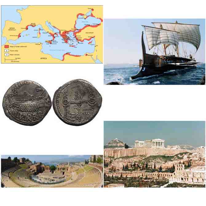
The Greek Empire was one characterized by many cities, trading, and great expansion. The map of this empire proves that Greece expanded over vast amounts of land on multiple continents, and making transportation connections was the only way the empire could succeed. An empire as successful as the Greek or Roman were comprised of multiple cities and city-states and one dominant center. Each city seemed to take care of itself but also specialize in something, often a food commodity. It would then be transported back to the empire’s center.
Shipbuilding was a large part of the Greek Empire. Because the empire developed on multiple continents, cities on opposite sides of the Mediterranean Sea connected through water transportation. Greeks became expert ship builders, and port cities were created. Accessibility to these coastal cities revolved primarily around those who were capable of shipbuilding and traveling at sea, meaning trade revolved around water transportation, and cities like Byzantium and Troy developed.
This is a contrast to the Roman Empire. Romans were ship builders as well, but they became experts in building roads. Thousands of miles of road connected cities across the empire, which allowed it to develop into one of the largest in world history. Within both empires, trade between the Mediterranean and Middle East was high. Items like cloth, spices and food were traded between these two different worlds, which is proof of the globalization that has been occurring and has affected development today.
In Greece, Athens was the center of the empire. It was also seen as a democratic center. The basis of democracy started in ancient Greece, with voting, public forums and public participation in government affairs. The ideas of this empire have carried on thousands of years to the US we know today. Entertainment was also a large part of the Greek empire, which is obvious by the picture of the amphitheater. These designs prove that architecture, planning, and public involvement were high in this empire. Because entertainment and democratic involvement were seen as important in this empire, cities were drawn so locations for these events could be properly created.
This empire is also known for its city planning and architecture. The many cities of this empire were designed intentionally to make the most of the land, which is obvious through their grid system, and Miletus is an example. City maps and grid lines were drawn, and within grids were set population counts. Often those drawing the grids did not take terrain into account into drawing, so objects like hills were ignored, which created oddly-shaped transportation routes. Within city centers there were plans as to where walk ways, monuments, theaters and markets would be located, markets that relied on trade and coinage such as what is pictured. Without these grids, cities would have developed in a disorganized fashion, with homes and public meeting places too close to one another.
Architecture in Greece has influenced infrastructure design for thousands of years. The Acropolis of Athens proves that designs of this empire were created so perfectly that they still exist today. There is hardly any infrastructure in the US today that could grow as old as pieces of architecture from the Greek empire. The Greek Empire was one of great design and influence. It impacted the Roman Empire, the US today, and others in world history.
Good discussion of the images
The positioning of the Greek Empire as the central intersection of trade and travel between Africa, Asia, and Europe played a large roll in the development and history of the Empire. The Greek Empire thrived around 3000 BCE and consisted of the Minoan, Cycladic, Mycenaean, and Hellenic civilizations and colonies.
The Minoan civilization was also the first documented advanced civilization and were home to the city of Crete. They were considered to be the first advanced peoples due to their vast export trade system of food, dry goods, and pottery, allowing them to have contact and trade with many foreign nations to advance themselves, this was most evident through looking at their art and architecture which developed its own unique style through these different contacts.
These colonies were all Mediterranean based and centralized around ports for both trade and production of food. The major Greek cities were gridded and planned in the fascist of governance, defense, and entertainment. Greek cities extended from the Balkans to the Mediterranean sea including multiple islands in the Mediterranean sea, allowing a vast and strong network of trade via the sea as well as through their system of roads. Some of these major cities include; Athens, Istanbul Byzantium, Marseilles, Alexandria, Beirut, Naples, Nice, Syracuse, Odessa, Tripoli, and Hear. The Greek Empire reached its largest size after the reign of Alexander the Great, extending the reach of the Empire to Egypt, parts of the Middle East, India, and Afghanistan.
The Greek and Roman cities were similar in their gridded and planned designs, but mainly different with the intricate and sophisticated design of the Roman road network. Also in the fact that the Roman empire expanded well beyond the Mediterranean coast where as the the Greek Empire was mainly centered around the coast solely. The most notable difference however was the sheer size of the different cities of the two empires. The Greek Empire had roughly 600 cities with populations ranging from three thousand to five hundred thousand at the largest, but the Roman Empire had the city of Rome with a population of one million plus its self alone. All cities within the Roman Empire were also developed for the sole purpose of supporting and growing the city of Rome and its one million inhabitants. The most notable fact about Greek cities and settlements however is the fact that none were surrounded by walls or defenses, indicating their peaceful and open-trade inclined environment of the Empire.
Straightforward discussion of the images.
The greek poleis were independent from each other, which meant that the political, judicial, legal, religious and social institutions had no influence from outside their city-states. Each polis had their own currency. However, the design of these urban centers had little variance from place to place. To understand the image of a polis, one must first know the definition of a city-state. It is a centralized, political region with an urban center and rural/suburban fringes. Ancient Greeks were among the first civilizations to introduce basic urban planning principles, which gave their poleis’ an orderly, gridded layout. Such is design of Miletus, the first example of greek planning, in which other city-states would follow suit. The population of a greek city was consciously limited in it’s size, with the exception of Athens. The greeks looked to Athens as an example of the consequences of excessive urban growth, which led to the loss of soil productivity for agriculture in the surrounding area, as well as transportation logistics problems from the city center to the fringes of the region. Because of this, populations of urban centers were limited to around 30,000. Some greek poleis were founded as a result of a other poleis exceeding their population limit. But for the most part, around 5th century BCE, greek poleis were planned around the needs of its citizens, with emphasis on trade, governance, defense, and entertainment. The plans of these cities included early principles of what would become the practice of comprehensive planning and zoning in contemporary city planning, as well as the distribution of public services. Certain districts were marked specifically for a certain purpose, such as one functioning as an administrative district, the other for the markets and others being either residential or military installations. Trade centered around naval transportation. Most poleis were built by the sea to facilitate ports for maritime trade. One exception was Athens, the largest of the poleis, which relied on the nearby port of Piraeus for its naval hub. Historians and Urbanists argue that the ancient greek civilizations owe their economic success to their city-state oriented development, stating that the cities themselves served as economic engines and the practice of urban planning led the efficiency of the poleis’ economies. The later Roman Empire would eventually borrow the concepts of city planning and utilize them in their own fashion. The gridded street was adopted by the Romans and innovated with the introduction of the cardo and decumanus. These were wider main avenues leading to the commercial centers of the city, also called forums. In contrast of the Roman design of cities compared to the Greek poleis, the Romans Forums differed from the Greek Agoras where the agora was an open space for markets while the forum was a more enclosed space with dedicated shops and offices. The populations of these cities were not restrained and the largest of the Roman cities, Rome, grew to reach over 1 million inhabitants during the Augustan era. This was one of the purposes of the cardo and the decumanus, which was to the accommodate the traffic of traders and military personnel.
“Ancient GreeceMichael LahanasGeography, Cities and Places.” Ancient Greece, Geography, Cities and Places. N.p., n.d. Web. Mar. 2017. .
Boone, Christopher G., and Ali Modarres. City and Environment. Philadelphia, Pa: Temple UP, 2006. Web. Mar. 2017. .
Polopolus, Leonidas. “ATHENS, GREECE: A CITY-STATE THAT GREW FROM OPTIMA1LITY IN THE GOLDEN ERA TO EXCESSIVE URBANIZATION BY THE 21ST CENTURY*.” ATHENS, GREECE: A CITY-STATE THAT GREW FROM OPTIMA1LITY IN THE GOLDEN ERA TO EXCESSIVE URBANIZATION BY THE 21ST CENTURY*. N.p., n.d. Web. Mar. 2017. .
“Roman Cities.” Roman Cities. N.p., n.d. Web. Mar. 2017. .
Good discussion of the images, good use of external sources.
Greece was made up of multiple independent states called city states. Each varying in size Athens alone covered close to 2500 square kilometers. Greek society consisted of mostly free people and slaves. These slaves served as servants and didn’t have any legal rights. Often being a slave meant you were a prisoner of war or just a part of the slave trade. Some slaves not many were paid and or had true skills in crafting or other special skills. As far as Athens goes they even began to create classes among the free people and call them citizens and metics. Which basically means you were either born from parents from Athens or you migrated into Athens and were born somewhere else. Citizens where given the opportunity to work in government and after working for the army often where expected to join the government. Citizens also had full rights. While metics weren’t allowed to hold positions in government but were sometimes forced to join the army to fight and protect a country that didn’t really value them as much. Greece was also the birth place of the democracy we see in today’s us government. Most of the city states of Greece were governed by the rich land owners in the city state. This form of governing is called an oligarchy. But Athens was governed by policies delivered by archons made by Aeropagus. Men in Ancient Greek men either trained in the military, worked for the government, or watched or performed the theatre. Women weren’t not allowed to go to the theatre and were reduced to more domestic life styles like washing and making clothes and food and house hold cleaning. One of their only public duties were acting as priestess at temples. Kids didn’t have many duties at all other than being kids and playing. Most Greeks had land outside the city and used it to make a living for their families. Grapes and olives where really important to Greek life as grapes were used for eating and making wine and olives were used for a great verity of things like olive oil, eating, cooking, and athletic purposes. Olives where so important that pulling a tree out from the ground was a criminal offence. which is shows just how important they were to them. The ancient Greeks main food source was breads and porridge and they ate that with fish, veggies, cheese and fruit. Meat was only a source of food when it was available. Because of Greece’s geological feature it made farming very difficult so the Greeks just used what they had and only had honey as a sweetener. Greece and Athens specifically were symbols of freedom, art, and democracy(university press inc). You could even say Greece was the farther/ other of western civilization we see today.
university press inc. –
http://www.ancientgreece.com/s/Culture/
http://www.ancientgreece.com/s/Geography/
Good points, although not very attached tot eh images.
Urban Geography Blog #1
The Greek Empire was a classical type city. Like the Phoenicians, they thrived on Mediterranean-based port colonies. They consisted of smaller clans and tribes; the Minoan, Cycladic, Mycenaean, and Hellenic civilizations. The Greeks had very planned, gridded cites. They led the world in trade and defense, using their advanced naval technology to quickly move goods and defend throughout their territory. They are known as a Thalossocracy, which means they were a sea-going nation. Most of their power came from their ability to traverse and defend the seas. Greece also led in government. They had elected officials in a democracy. Entertainment was greatly important to this society. Thespis, a Greek man, became the first actor in a play. Plays, musicals, battles, etc. were all apart of Greek Culture. Some of the major colonies of the Greek Empire were Istanbul, Alexandria, Beirut, and Tripoli. These cities where subservient to the capitol: Athens.
The Roman Empire rose after the Greek Empire ended. Much like the Greeks, they were powerful on the seas, but the Romans went beyond the Mediterranean, inland. Like Greece, they had very planned, gridded cities. One thing that the Romans mastered that Greece did not was architecture. Yes, Greece has many significant structures, but the Romans took the science of building farther with engineering. Rome build fantastic, lasting roads to connect their colonies. Many of these roads are still usable today. They also created the aqueducts with precision. This provided water to the one million people in Rome in a way no city had seen before. Their technology also translated to the battle field. They created the javelin, a spear that could not be thrown back in attack after it was used. Their intense training led t excellent military strategies such as the phalanx in which soldiers would make a nearly impenetrable force by interlocking their shields.
The Roman system was hierarchical. Each colony had a size-related function that served Rome. Rome, as the center of the Empire showed its power by offering citizens bread and circuses. This was a way of keeping people happy. The bread was only about 75% of what was needed to survive, but it was much better than having to work for 100% of the food needed. The circuses brought entertainment to a whole new level. Gladiator games were Rome’s version of NASCAR. Everything in Rome was a show of its power throughout the known world.
Both the Greeks and the Romans made incredible advancements in politics, military, trade, art, science, and entertainment. Most of all they set the framework for civilization, especially in Europe. Rome’s roads and Greece’s grids created many of today’s European, North African, and Middle Eastern cities. Without these nations, our view of Urban Geography would look much different. I think about how Asia, North and South America, and Sub-Saharan Africa look as compared to the areas that these two powers conquered. Could it be that much of the headache and heartbreak that happens in those places are almost unheard of in Europe and MENA because of the Greeks and the Romans?
Very nice.
The ancient Greeks were not great mariners by happenstance. The climate and topography of their lands shaped their urban forms, culture, and eventual empire. Rugged mountains, cliffs, and rivers made up most of the land and very little farmland was available, thus leading to a heavy reliance on the sea for the easiest transportation and available food. The Phoenicians first controlled much of the Mediterranean through sea trade and piracy. The Greeks settled for these reasons in more defensible and mountainous locations more inland. It’s believed that their settlements began atop areas such as Athens’ acropolis then grew outward and throughout the lower grounds as populations grew and the abilities to better protect themselves grew.
The geographic barriers of their land also influenced their governance- more often than not conflicting, independent, seafaring city states. A unified Greece would be no easy task so smaller but powerful states such as Athens and Sparta were the norm. Even after Phillip II of Macedonia conquered the Greek cities, they continued to rule themselves independently while being forced to join the Corinthian League.
Their peak size and power was not technically Greek, but Macedonian, as Alexander the Great (the ruler at its peak) was the son of the Macedonian king Phillip II that had forced most of the Greek city states to join his empire. The pattern of expansion was island based, establishing colonies along the coasts and conquering coastal cities. Their thalassocracy was both highly profitable from the Mediterranean trading networks, and ideal for the rough terrain encompassing almost all the coasts.
The largest city of the “Greeks’ was founded by Alexander the Great in northern Egypt- the port city of Alexandria (one of many Alexandrias he established, but also the largest). It was second to Rome in size for comparison. As Alexander’s empire stretched eastward, establishing ports from India to the Persian Gulf, Alexandria became the center for shipping from the east to the rest of the Mediterranean. It became a rapidly growing cosmopolitan city that attracted intellectuals from all over and boasted the title of largest city of the known world for a time. Eratosthenes, Euclid, and Archimedes are just a few of the great minds who lived there. The great Library of Alexandria was made possible by the continuous flow of thought and cargo of the port. It’s said that all ships that entered the harbor were searched for books (scrolls) and valuable works, either confiscated or copied to be housed in library. The port also was home to the first lighthouse built for shipping, Pharos, one of the seven wonders of the ancient world. It was built in 280 BCE and used mirrors to reflect and increase the intensity of light that could supposedly be seen from 40 miles. The city’s form was adopted by the principles of Hippodamus of Miletus- a grid of streets that radiate from from the central Agora.
Sea trade was of utmost importance for the maintenance and survival of the empire, for the growing urban populations that did not farm needed to be fed, and hinterland travel was practically nonexistent because while the Greeks were great mariners, they could not build proper roads. Thus most colonies established were limited to the coast and did not provide as much food as hinterlands could. They did become powerful enough with their sea trade empire to establish colonies of specialized labor that only produced a single product, such as Paestrum’s rose petals for rosewater perfume.
http://www.greece.org/poseidon/work/articles/polemis_one.html
http://www.ancient.eu/alexandria/
Very nice discussion.
The Greek Empire has a long history that spans many defining eras and has continued to influence the organization of following empires and regions as well as architecture for years to come. Ancient Greece began with established civilizations such as the Minoans and Mycenaean, went through a Dark Age, followed by the Archaic period, the Classical period, and the Hellenistic era.1 As Ancient Greece evolved through these periods of time, it also expanded its empire over many different regions along the coastline of the Mediterranean Sea. The satellite cities of the “capital” of the Greek empire, Athens, were mainly port cities that operated by using sea routes for trade and export of goods to Athens. Eventually, some of these cities came under control of other empires that rose to power over the Greeks, but the Greek influence remained.
Each of the Greek cities was unique in their own way – they had different contributions to the empire and their own character defining identities. Several Ancient Greek cities that have changed but in some form still exist today are Poseidonia (now Paestum and part of Italy), Smyrna (now Izmir and part of Turkey), Heliopolis (now Baalbek in Lebanon), and Massalia (now Marseille in France). Poseidonia (Paestum) was founded in the 7th century BCE and thrived as a Greek city – it even had its own currency which was rare for that time – until it was taken over by the Lucanians and later the Romans. It is located in southern Italy near present day Salerno south of Naples and Pompeii. Today, it is known for the well preserved sacred temples built by the Greeks in dedication to Hera, Poseidon, and Athena.2 Massalia (Marseille) was founded by Ionian Greeks from the eastern side of the Greek empire in the 6th century BCE and opened a critical connection for the Greeks to the known western world in their expansion.3 This exemplifies the dominance that the Greeks had over creating new maritime trade. This only describes two cities, but each of them provided groundwork for future development and adaptations. A commonality found between them is a planned grid system for development that later continued to be implemented even when other empires came to rule. The Greek temples that were constructed were also adapted by following empires. They were used for the worship of similar deities, some later used as basilicas, or converted for governmental purposes. References to Greek planning and architecture were frequent among the empires to follow.
A lot of the ancient Greek cities that were founded on the expansive edges of the empire did not sustain the bolstering economy they once had while under Greek rule. For many of them that were later ruled by the Romans, it seems that one reason they declined was because of the major shift from maritime trade to a trade system based on land crossing roads. Some Roman built roads bypassed the cities oriented towards the port, similar to some situations today where a new major highway bypasses a small rural town and the town loses traffic and business.
1 Kuiper, Kathleen. Ancient Greece: from the archaic period to the death of Alexander the Great. New York: Britannica Educational Pub., 2011
2 Cartwright, Mark. “Paestum”. Ancient History Encyclopedia. 2016 (http://www.ancient.eu/Paestum/)
3 Wasson, Donald L. “Massilia”. Ancient History Encyclopedia. 2013 (http://www.ancient.eu/massilia/)
Good use of outside sources.
The history of Greece can be traced back to the Minoan and Mycenaean kings. Their civilization began in 2700 BC. Greek Empire was one of the first empires settled on the Mediterranean Sea. Its cities also known as states were based on the sea and they colonized countries that settled the Mediterranean Sea. They had different functions and produced different goods, but they were mostly known for fishing and trade. Their system of governance was organized in such way that these states would exchange their goods with other states of the empire, that helped manage the surplus each state would produce.
A characteristic of cities of Greek Empire is their settlement system. Greece itself has a mountainous terrain, this made it possible for their cities to settle in the shores of the Ionian and Aegean Sea. They did not settle far into the hinterlands because Greeks unlike Romans did not have a developed ground transportation system. These cities had various functions. They were planned and had a grid system which was first introduced in Greece. They were known for their system of governance and defense, but they also provided entertainment areas for their citizens. Most known Greek cities were: Athens, Istanbul, Marseilles, Alexandria, Beirut, Naples, Nice, Syracuse, Odessa, Tripoli, Herat etc. In the cities of ancient Greece fields such as mathematics, literature, philosophy, history, drama, Olympic Games, and democracy were born and we benefit from these values still. The work of Greek philosophers and their writings offer a basis of knowledge that still today cannot be surpassed.
Greek cities had a system of city planning that was invented from Hippodamus. Its streets were straight and the city was designed with the wind movement so it would provide a cooling system during the summer. He introduced the grid system and city blocks. They build the houses directed toward the sun for better heating. He also developed the concept of owning land. An interesting setting in the city planning in Greece is that they had different guidelines regarding the different models of the city and where they will build it. For example, the wind movement, the heat, the sun, positioning of the city, wine, grain, fruit placement, etc. are just some of the guidelines they worked on to plan a city. Such detailed planning offers a perspective that even in the Greek empire they put a great emphasis on how to plan a city. Its most important factors and details were laid out in a grid system making sure that in the center are the areas for governance, temple, forum, etc. However, the Greek cities had also planning for security projecting walls around their city center to protect inhabitants from the enemies, specified planning for higher protection. All these specifics characterize Greek Empire and its cities. They persuaded a form of planning and governance that created a foundation to other empires that came after. No better we see this than in Roman Empire which got the grid system of the streets and the forum and implemented that in their buildings. Greek empire has created the foundation to many areas of life which we benefit still today.
http://www.hellenicaworld.com/Greece/Technology/en/CityPlan.html
Good discussion, not very closely related to the images
Good discussion.
The Greek Empire was largely based on port cities lining the Mediterranean Sea. The location of these cities created an extensive trade empire. Unlike the Roman empire, Greek Empire did not extend into the hinterland, the cities remained exclusively coastal. Trade across the Mediterranean was essential to the expansion and growth of the Greek Empire. City-states within the Greek Empire would often trade wines, figs, cheese, meat, pottery, tools, and perfumes. Greece was a thalassocracy meaning it was a seaborne empire. This explains the Greece’s power over Mediterranean trade and colonization.
The Roman Empires trade was vastly different from the Greek’s because their trade did not solely depend on the Mediterranean Sea. The Romans build an extensive road system connecting trade among Roman Empire cities. This road system allowed the empire to trade internally and also allowed the Roman Army to move easily from city to city. Another difference would be that the majority of Roman cities would send their goods to Rome to supply the large population with adequate resources. Many Roman cities were created to export a specific resource and they also had size-related functions. Rome was emphasized as the center of the Roman Empire to signify Roman power.
The Greek Empire extended its horizons “from the Mediterranean to Asia Minor, from North African to the coast of the Black Sea” (“Ancient Greece”). The empire had hundreds of colonizations around the coast of the Mediterranean and these settlements were independent city-states. These were self-sufficient cities but every city-state under the Greek Empire was unified with the same language and religious beliefs. The Greek Empire worshiped the twelve major Olympian gods and every city-state worshiped these gods in the same way. Despite these similarities, city-states operated in very different ways. For example, each city-state had a unique government, army, and laws.
Greek cities were arranged in a particular manner. The highest point of the city was referred to as the acropolis which was considered a sacred land where the gods dwelled. This area was home to the most popular art and architecture of the city and could often be viewed from other parts of the city due to its height. The agora is another aspect that is specific to a Greek city. The agora is placed low on the ground and is an open place of assembly. A variety of activities took place in this gathering area such as religious activities, political meetings, social gatherings, and cultural rituals. The outskirts of this gathering center were marked by public and government buildings. There were also shaded walkways around the agora to provide people with another area to socialize. Before the creation of the Greek theater the agora was also home to singing, dancing, and even plays. The Greek theater was the first opportunity giving actors a stage to perform on, thus the birth of Greek theater. The theater was often built on the hillside to give natural sloped seating and picturesque views. On these stages actors would produce tragedies, comedies, and satyr plays and would perform in different festivals. (Word Count 509).
“Ancient Greece.” History.com. A&E Television Networks, 2010. Web. 27 Mar. 2017.
Nice discussion of city form.
The Mediterranean coastal-based cities of the Greek Empire continue to serve as important markers on the development of sophisticated urban planning and geography. The ancient Greek Empire was composed of a series of city-states given regional autonomy but connected through a common Greek through-line of trade and culture. Most Greek cities retained familiar forms of gridded urban centers as well as defensive fortifications and entertainment structures such as amphitheaters and colosseums. Physical geography of this Mediterranean region had a massive impact on the development of the Greek city. Because the Greeks lived in and around clustered island chains and coastal chains, maritime travel and navigation developed out of necessity in the region. However, because of poor communication between these cites due to inland geography preventing more expansive travel networks, these Greek cities then began to develop distinct and personal cultures and systems. Therefore, the Greek Empire itself became a heterogeneous combination of various city-state cultures scattered along the Mediterranean and connected by extensive seafaring technology. One of these city-states that developed its own unique voice and identity, for example, was Athens, which can be seen in the lower right image of the collage. Athens became a powerful player in the creation of early theories concerning science, philosophy, art, and many other fields as they exercised focus on scholarship. They also worked under a democratic form of government which was not widespread throughout the Greek Empire. Compare the Athenian city-state to a place like Sparta, for example, and we start to understand how uniquely these Greek cities could diverge from one another. Sparta was ruled by military powers that concentrated all political control of the region and the culture of the city-state emphasized military strength. The devotion of the Spartan to flexing military strength left for little development of art and architecture which we know Athens famously developed into what we consider classical style today. Coincidentally, these two city-states that established such different voices and cultures from one another would come to blows in the Peloponnesian War. Ancient Greek city-states also had intricate trade systems and networks that mostly operated independently from the state governments themselves. As we discussed in class, the trade system for the Greeks was widely based on the specialization of goods and services in certain areas and the exchange within the Empire for the rest of the necessary goods needed for the region. The rocky geography of much of Greece made it difficult to consistently farm or access certain goods across the empire so systems of maritime trade helped alleviate the stress of the Greek governments to provide for their inhabitants. While the Greeks had a sophisticated system of city-states and maritime trade, their inability to expand beyond the coastal regions would eventually lead to decline. The subsequent Roman Empire would move beyond this hindrance and develop a powerful system of roads and trade routes that let them expand even further beyond the Mediterranean and extend their political influence. The Romans still allowed regional autonomy to most areas they controlled but the Greek city-state stands out as a distinct testament to why ancient Greek cities and cultures are so diverse.
Good discussion
Urban Geog blog post #1
Greek cities are often hailed as the first early cities of the classical era and the predecessor of the early modern city. This is due to the high concentration of culture and the significance we put on it today as well as the distinguishable gridded design that is still being used today.
The geography of Greek cities was crucial to the economic base of the Greek empire: trading. Many of these cities, located on the coast of the Mediterranean and Black Sea, were ports for specific exports or industry. Cities with specialized and specific industries existed within the Greek Empire, but were most effective in the Roman Empire, which had the economic capacity to support such cities. These ports cities were planned around their industry and even used the topography of the land to dictate some of their architecture. The Greek Empire was effectively as “Thalassocracy”, drawing power from its dominion of the sea.
The Greek port cities were gridded and planned around the trade the area provided. There were small, local governments set up in each city, and a regulated defense, usually a wall around the outer inland side. The grid of the city provided direct access to the trade port. The grid was an easily replicated design that catered to the need for public access to certain spaces, like the temple, theater and government building. A good example is the city of Miletus, one of the earliest gridded port cities. Other famous cities built as part of the Greek Empire include: Athens, Istanbul, Marseilles, Alexandria and Beruit. The roads did not go far beyond the small port cities. Most Grecian cities had small hinter lands because of this. The dysconnectivity of these cities (apart from sea trade routes) would aid in the decline of the Greek empire because once their sea-faring ships and trade network were over thrown, there were no other systems to hold the small city-states together.
The most iconic of the Grecian architecture is the Greek theater. Built in nearly every substantial Greek city, the theater was a central part in Grecian culture. The theater was a place of entertainment, the location of theatrical culture and some religious festivals. Theaters were built on hillsides, using the slopes to amplify the sound. This design was easier to accommodate in the sloping topography of modern day Greece, Turkey and parts of Northern Africa. The large Greek theaters and temples, were architecture of power, much of the materials used were imported, and showcased the vast abilities of the Greeks.
Nice discussion.